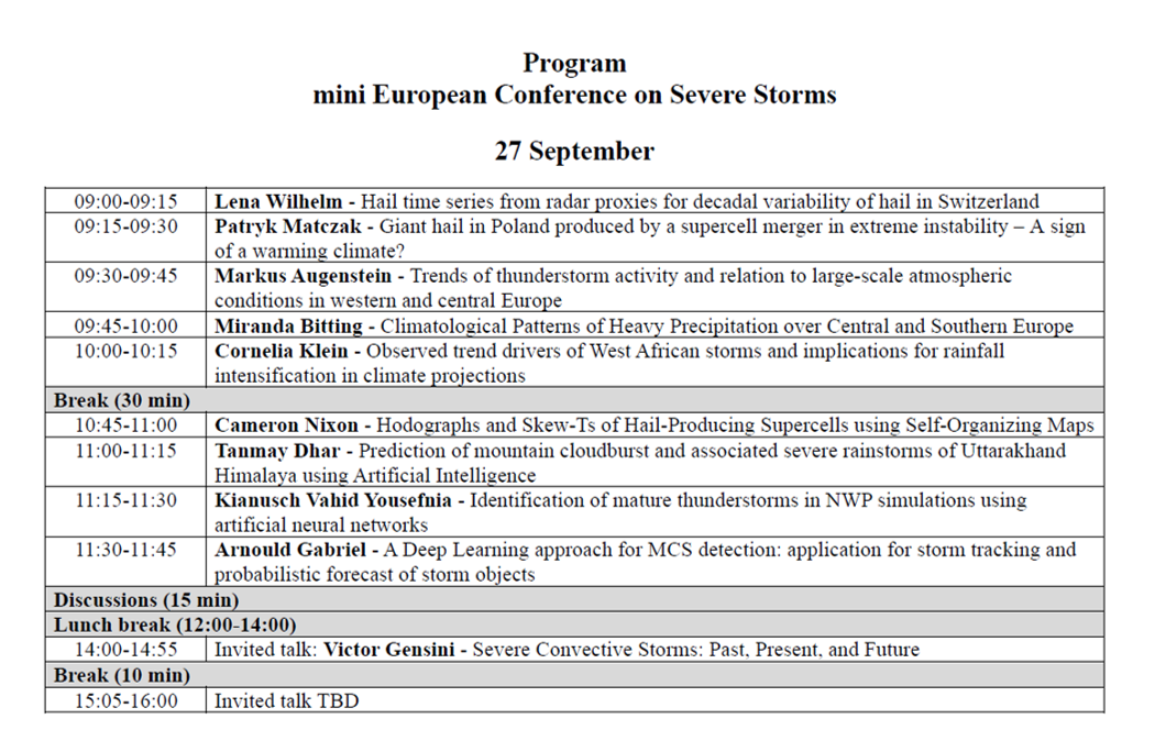
Mini ECSS is around the corner and you can find the latest information about it here! The conference is held online on 27 and 28September. On both days the program will start with student presentations at 9 AM CEST (7 UTC) and there will be two invited talks each day starting at 2 PM CEST (12 UTC). In case you forgot, there is still a chance today (i.e. 26 September) to register to attend the conference!
All registered participants will be sent a link to the Bluejeans that we will use for the conference. The program can be found below or downloaded.
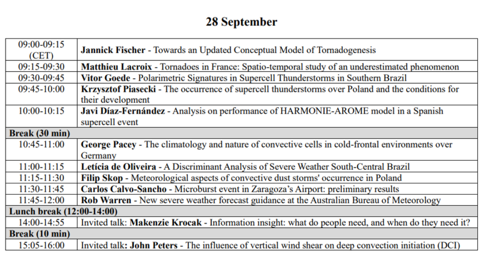
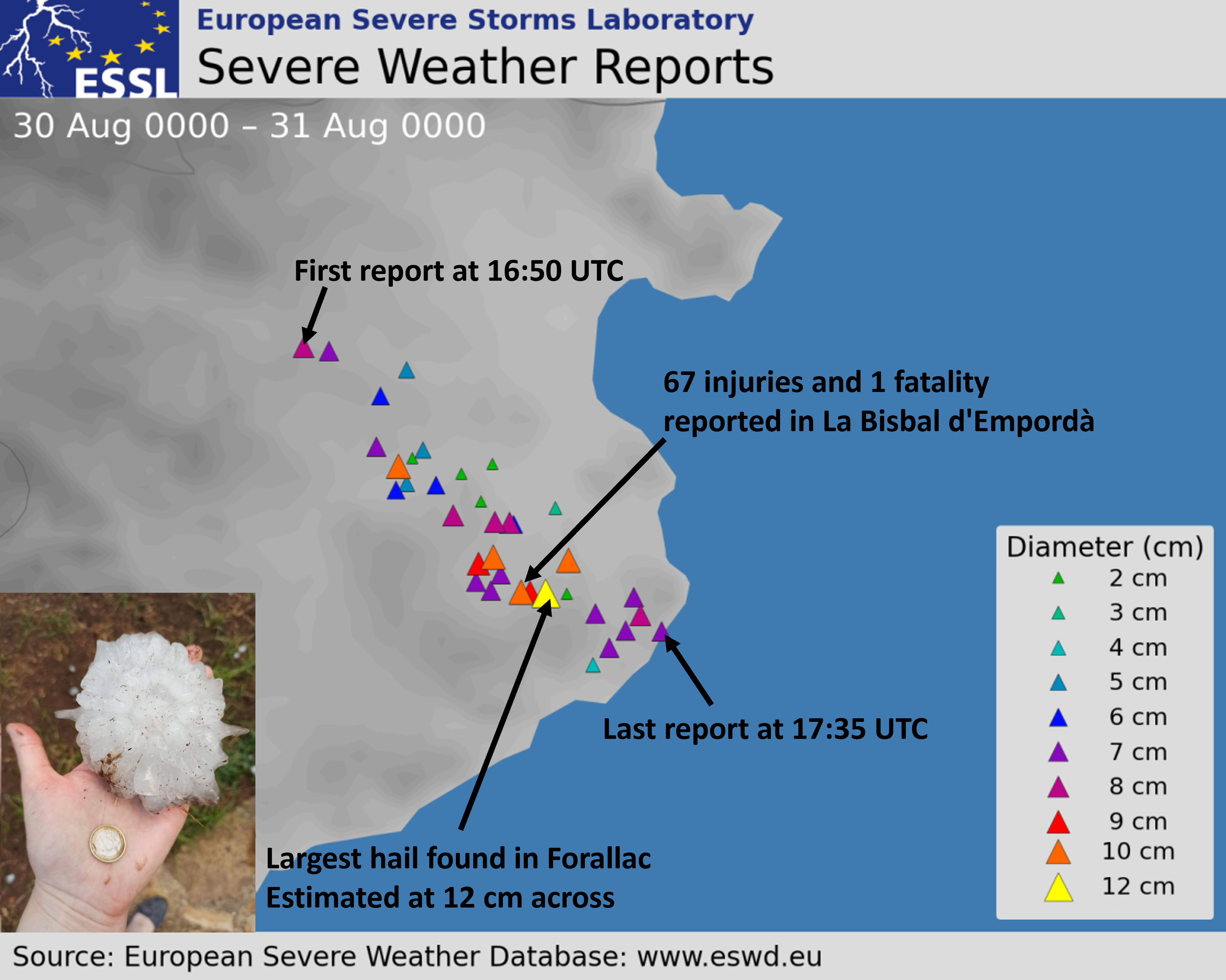
In the late afternoon of 30 August 2022, an extraordinary supercell storm formed over the eastern Pyrenees. The storm quickly started to move to the right of the mean wind as it entered the district of Girona in Catalonia, producing a swath of very large hail (≥ 5 cm) between Esponnellá at 16:50 UTC and Tamariu at 17:34 UTC, after which it moved over the sea.
Sandwich satellite image of the hailstorm over Northeast Catalonia on 30 August 2022 at 17:30 UTC, and surface station measurements of the wind, temperature (red), and dew point (green).
Multiple reports of hailstones larger than 10 cm in diameter were collected with the largest stones estimated to be 12 cm. Based on some videos, the hail fall was relatively dense for stones of that size. The impacts of the storm were high: Besides serious damage to roofs and cars, 67 injuries and even one fatality resulted in the town of La Bisbal d’Empordà. 28 people had to be taken to the hospital, including one serious head injury. Based on our study on hail impacts across Europe, this was the first direct hail fatality in Europe since 1997. Furthermore, the number of injuries ranks as the third highest recorded in the ESWD for large hail events.
Given the societal and economic impact of this hailstorm and the fact that the giant hail has already been reported 18 times in Europe this year, we look at the predictability of this particular event from the perspective of the large-scale, pre-convective environment addressing these two questions:
How likely was the convective initiation?
How likely were the initiated storms to produce giant hail?
Limiting ourselves to the large-scale environment we do not address two important sources of data: high-resolution convection-allowing models and nowcasting data, such as products based on radar
How likely was the convective initiation?
With an abundance of low-level moisture along the coastline and steep mid-tropospheric lapse rates advected from the interior of Iberia, high convective available potential energy (CAPE) was present to support the development of severe thunderstorms.
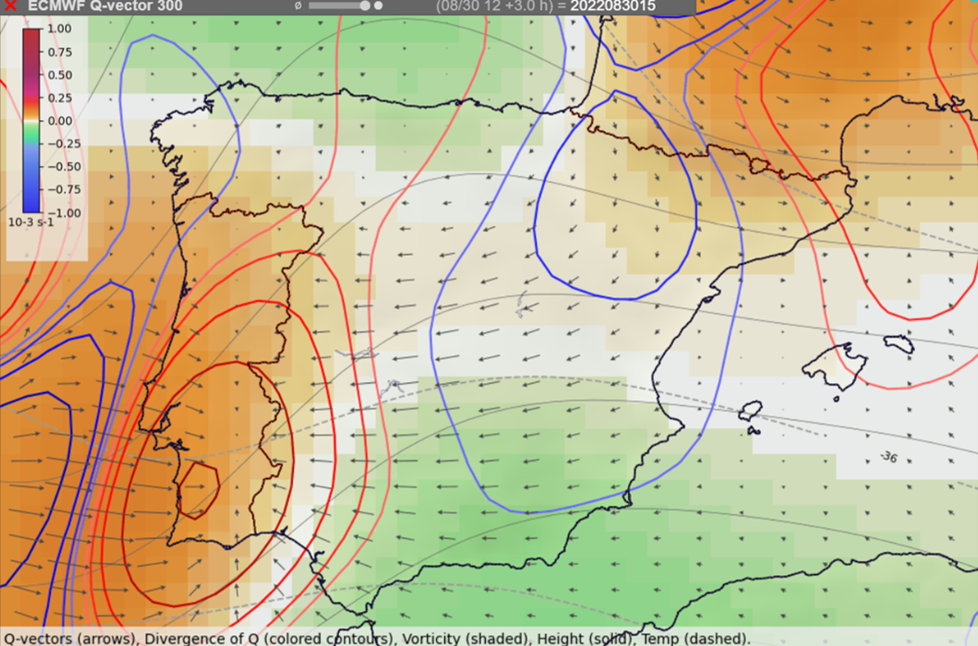
With this potential being present, the most important question was if a trigger strong enough to set this energy free would be available in this environment. The synoptic-scale lift was forecast only over extreme northeastern Spain and in the upper troposphere near 300 hPa, but not at lower levels. With the absence of fronts or other large-scale air-mass boundaries, the mesoscale lift had to come from an upslope flow of maritime air against the high terrain.
Locations of where large-scale upward (red contours) and downward (blue contours) vertical motion is to be expected based on Q-vectors at the 300 hPa pressure level.
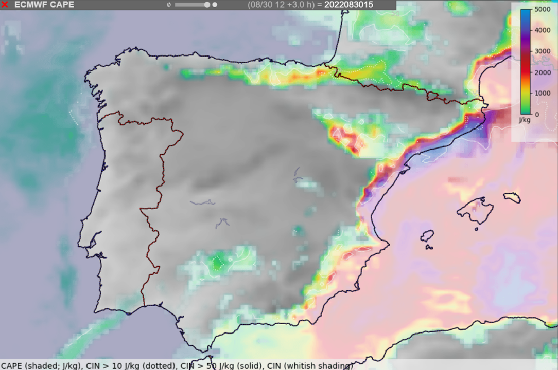
Convective initiation across Spain was complicated by a substantial amount of convective inhibition (CIN), negative energy to be overcome before a storm can form, especially over the southern part of Iberia. Near the eastern coastline, CIN rapidly increased from the mountains towards the coastline, restricting the ability of the storms to tap into the moisture- and CAPE-rich air mass. The largest area of relatively low CIN (< 50 J/kg) existed over far northeast Iberia, where the supercell formed.
Combining the lowest CIN and the presence of at least some synoptic-scale lift over far northeast Spain, with hindsight it is possible to pinpoint this area as one with the highest probability of storm formation. Severe hailstorms are often isolated cells, rather than storms which are embedded in a larger convective system. On the 30 of August, the absence of widespread mesoscale lift and the presence of some CIN in the environment probably helped to limit the number of storms that formed to the one storm that produced the giant hail.
While it is easy to retrospectively explain the isolated nature of the storms on this day, beforehand it was not possible to state with certainty what will be the exact track of the storms or whether there will be three or no storms at all.
Forecast of the ECMWF IFS model of CAPE (colors) and areas of convective inhibition (whitish shading) at 15:00 UTC.
How likely were the storms to produce giant hail?
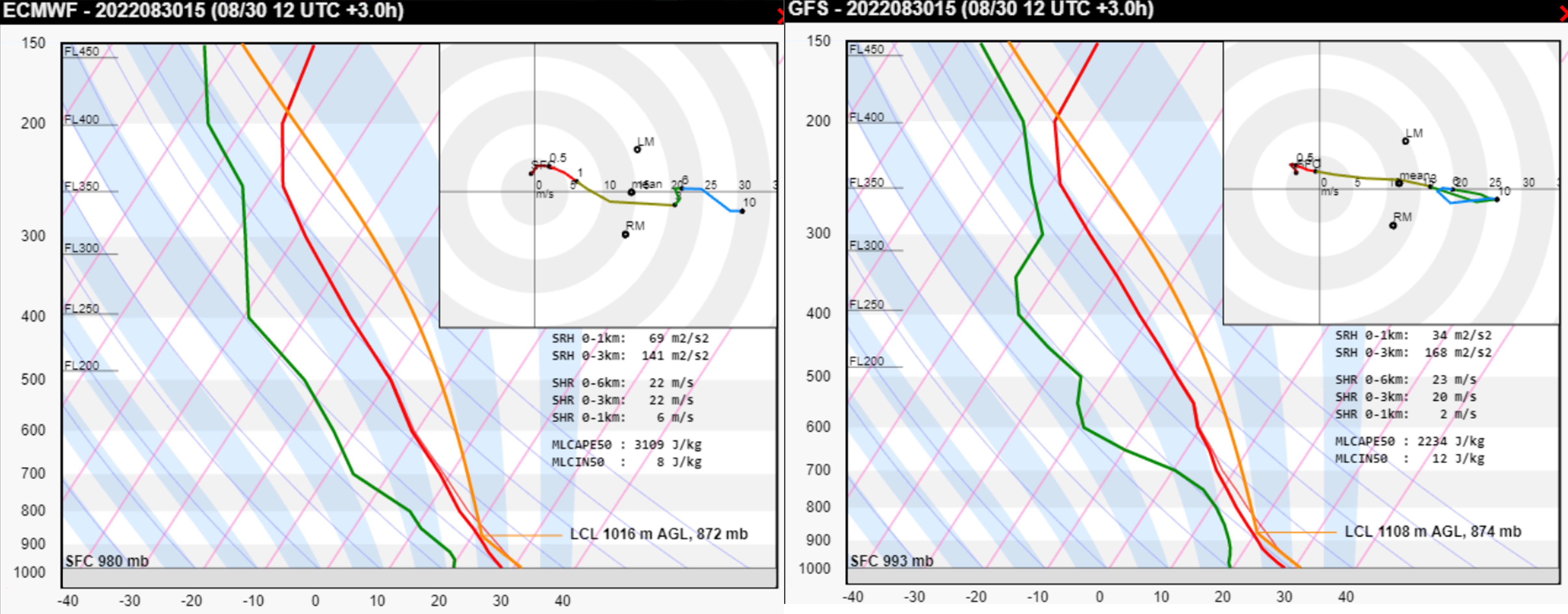
The supercell moved into the environment that has been found to be very conducive to severe weather, featuring high CAPE and strong vertical wind shear. Considering the model-simulated Skew-T and the surface observations from the area (temperature of 29, dewpoint of 23°C, and 5 m/s SSE wind), very large hail production was supported by:
High values of CAPE (MLCAPE ≈ 4000 J/kg) with large amounts of CAPE found in the temperature zone < -10°C
Vertical wind shear supportive of supercells. Very large hail occurs almost exclusively with this type of convection. Furthermore, strong shear resulted in a strong inflow into the storm. Based on the simulated hodograph, observed surface wind and observed storm motion, the surface inflow into the storm was almost 20 m/s. Strong inflow supports wide updrafts and wide updrafts lead to long hail embryo residence times in the favorable growth zone.
Unidirectional vertical wind shear (i.e. straight hodograph). Straight hodographs have been found to be more conducive to large hail growth than curved hodographs.
Both low-level shear and storm-relative helicity were quite weak in this case. Unlike for tornadoes, high values of these parameters are not necessary for very large or even giant hail.
ICON-EU forecast of CAPE, 0-6 km bulk shear at 15 UTC with the model Skew-T and hodograph for the location represented by the red cross. The red star within the hodograph marks the observed surface wind and the blue star the observed storm motion. The black arrow is the surface storm-relative wind (i.e. inflow at that level).ECMWF and GFS forecast soundings for 15 UTC. Note the underestimation of surface dewpoint.
Supercell also profited from being the only storm around with no disruption to its inflow and updraft. Its deviant motion to the right was also more pronounced than anticipated by the Bunker’s ID method, suggesting the presence of a strong mesocyclone.
Was it possible to make a confident forecast of the storm producing hail reaching 10 cm? Such a forecast would be useful, as 10+ cm hailstones have a higher probability of causing both damage and injuries compared to 5+ cm hailstones. However, hail diameter doesn’t linearly increase with increasing CAPE and shear. For example, increasing CAPE may even limit the large hail production beyond some point. There are likely other factors that influence the trajectory of hail embryos through the updraft and their residence time in a zone of abundant super-cooled water droplets. Some of these are covered in a lecture by Matthew Kumjian. Testing these factors against a large sample of very large or giant hail cases will perhaps bring us even closer to confident forecasts of such devastating hailstorms.
In conclusion, the combination of very favorable large-scale conditions for hail with isolated convective initiation resulted in a perfect scenario for a damaging hailstorm. Such knowledge provided a good chance to correctly nowcast the event once the storm entered a supercell stage.
On 18 August, severe storms occurred in a swath from Menorca through Corsica, northern Italy, Slovenia, Austria, and southern Czechia. The event featured giant hail up to 11 cm in diameter and extremely severe wind gusts up to 62.2 m/s. In total, 12 people died and 106 people were injured by wind and hail. All fatalities, and most of the injuries, were caused by a long-lived convective system that produced a swath of severe to extremely severe wind gusts. The windstorm event can easily be classified as a derecho, a particularly long-lived and severe convective windstorm as the official criteria for a derecho were clearly met: its damage path exceeded 1000 km in length and wind gusts > 32 m/s were measured in Corsica, Italy, and Austria along the path of the storm.
Temporal evolution of ESWD reports for the event between 00 and 24 UTC.
This article describes in more detail the evolution of the event and its relation to the environment.
Temporal evolution of the derecho The first severe wind gust report was observed at 06:15 UTC in western Corsica. The last severe wind gust report was reported at 17:45 UTC from Czechia. Severe weather reports indicate that the derecho lasted at least 11 hours and 30 minutes. However, it is almost certain that the severe wind gusts occurred already sooner than 06:15 UTC. The severe wind gusts probably occurred as soon as 05:30 UTC, when the bow echo began to form. This means that the severe wind production in the storm lasted likely for more than 12 hours.
17 August
21:00 – 00:00 UTC: Storms initiated over the Balearic Sea. One of the storms became a right-moving supercell and intensified.
18 August
00:00 – 03:00 UTC: The right-moving severe storm grew in size and impacted Menorca. Heavy rainfall and severe wind gusts were reported. Further storms formed to the north.
Airmass RGB showing a severe storm over Menorca and a pronounced trough over western Spain and the Balearic Sea. Courtesy: EUMETSAT.
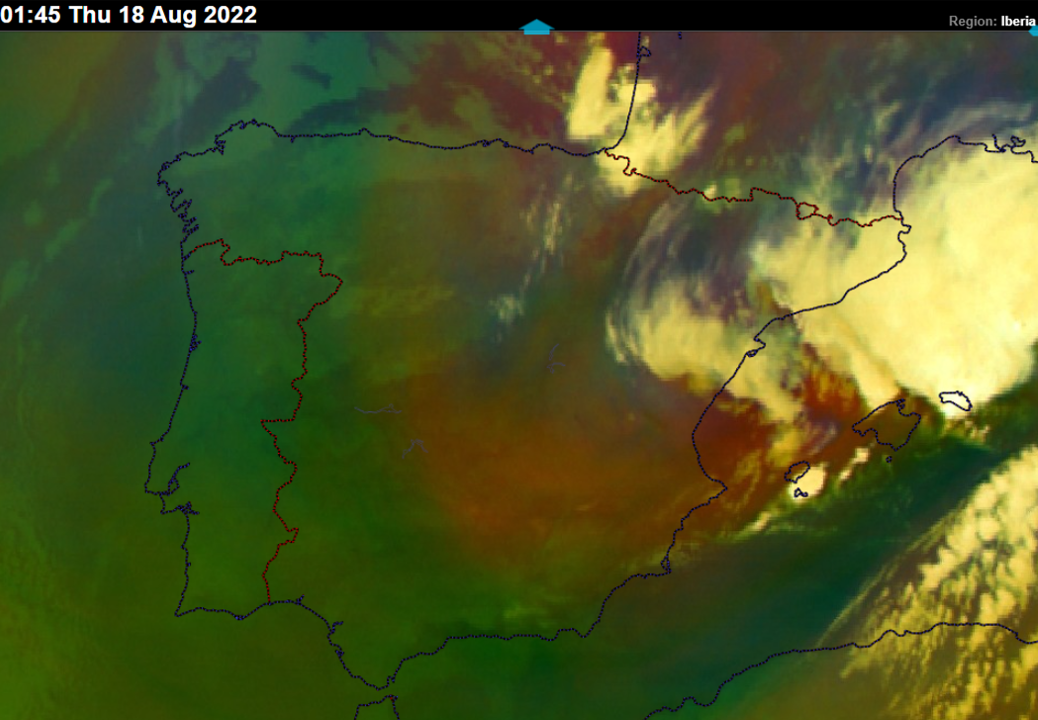
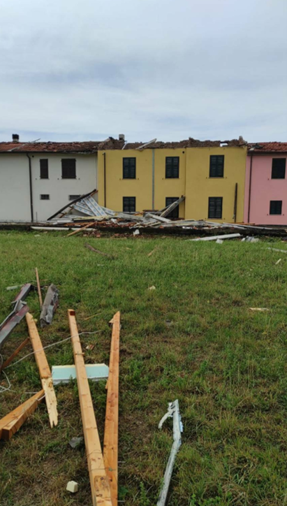
03:00 – 05:00 UTC: The storms continued to grow upscale and became a squall line. In the same period, a supercell ahead of the main storm system impacted Lavagna and Sestri Levante in Liguria, Italy with wind-driven hail up to 5 cm in diameter. 22 people were injured in this event. Cars, roofs, and facades of houses were badly damaged by hail.
Wind-driven hail damage to the house facade in Sestri Levante, Italy. Photo by Gherardo Ghotti.
05:00 – 06:00 UTC: The squall line transitioned into a bow shape just ahead of reaching Corsica with an increase in lightning activity and rapid acceleration towards the island’s western coastline.
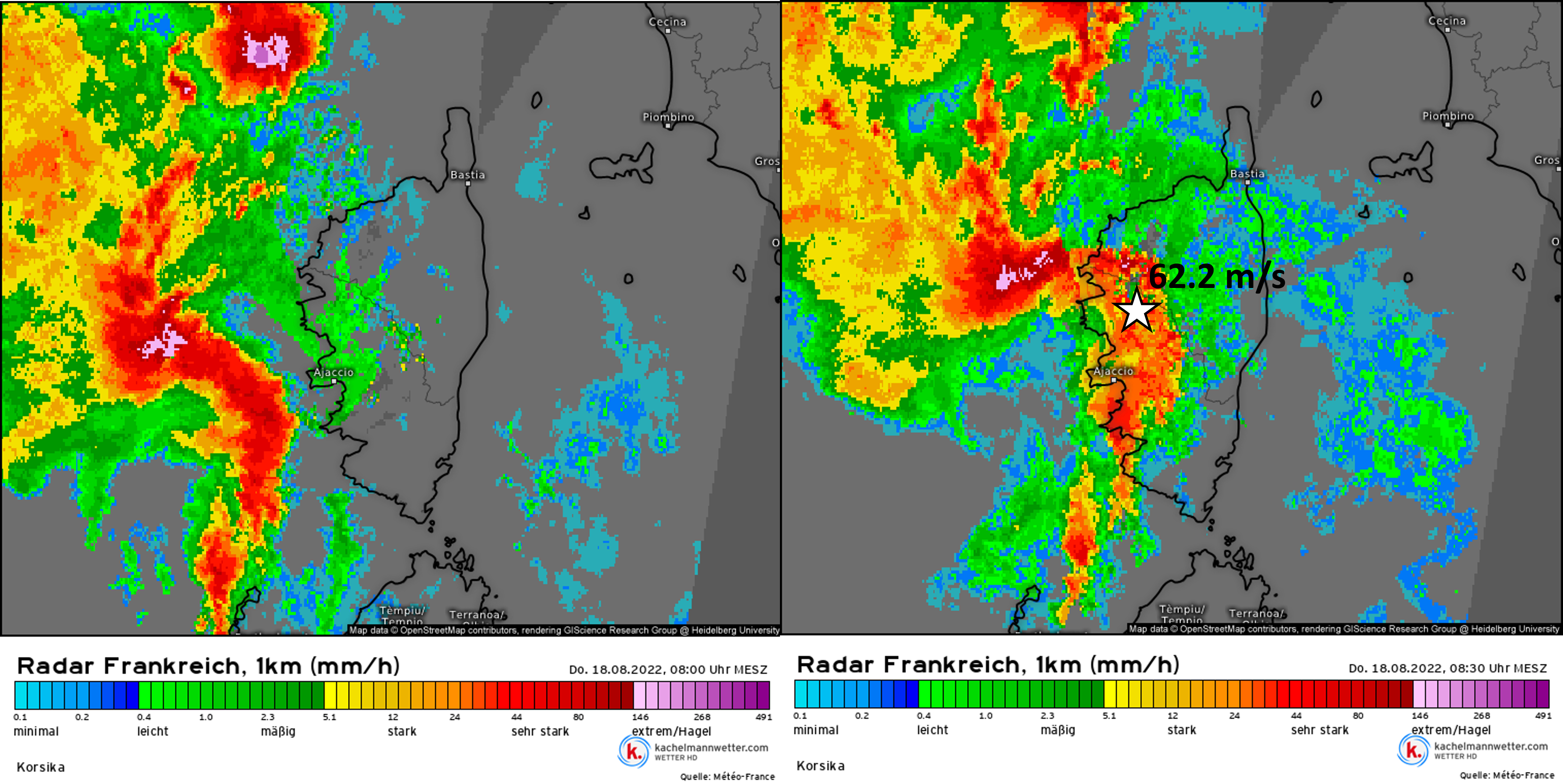
06:00 – 07:00 UTC: The bow echo passed Corsica with extremely severe wind gusts up to 62.2 m/s in Marignana, a station located on a hill. Two other stations in Northwest Corsica measured wind gusts above 50 m/s. 4 people died and 10 were injured in this time frame. Severe winds capsized boats or blew the boats against the rocks and beaches. Damage to the roofs and power lines was reported. The updrafts of the storm, as well as lightning activity, weakened as the bow crossed the island.
07:00 – 08:00 UTC: The bow echo passed the northwestern part of Corsica and continued over the sea. 1 person died in this part of Corsica and wind gusts reached up to 34.4 m/s. Updrafts increased in intensity again as the bow entered the warm sea, as indicated by an uptick in lightning activity.
08:00 – 09:00 UTC: The bow echo impacted the western Italian coastline of southern Liguria and Tuscany with extremely severe wind gusts up to 38 m/s, causing widespread wind damage to trees and roofs. Some roofs were completely destroyed or blown away. 2 people died and 45 were injured. Lightning activity weakened and also the wind damage became more isolated as the storm passed the Apennines.
Roof damage in Ortonovo, Liguria, Italy. Photo byCittà Della Spezia.
09:00 – 10:00 UTC: Lightning activity of the storm increased and new updrafts developed over the lowlands behind the Apennines.
10:00 – 11:00 UTC: The storm system moved over the Veneto and Emilia-Romagna regions of Italy. Severe wind gusts reached up to 38 m/s and 9 people were injured.
11:00 – 12:00 UTC: The lightning activity decreased again as the storms reached the border between Italy and Slovenia. 2 injuries were reported in this period.
12:00 – 13:00 UTC: The system produced severe wind gusts over Slovenia and moved over southern Austria, where the storms intensified again. At the same time, a severe storm over Menorca produced very large hail up to 7 cm in diameter.
13:00 – 14:00 UTC: The system produced wind gusts up to 38.6 m/s in south-central Austria, mainly in Styria and Carinthia. 2 people died and 13 were injured in Mettersdorf. High voltage power lines were brought down by the winds. Storms were now traveling north.
14:00 – 15:00 UTC: The convective system continued producing severe winds over Austria with a maximum gust of 34.4 m/s as it traveled north. 3 further fatalities occurred in Styria as trees fell on hikers trying to protect themselves from the storm.
15:00 – 17:00 UTC: The system started decaying shortly after 16 UTC over northern Austria. Still, it managed to produce severe wind gusts over south-central Czechia.
Further storm activity in the evening yielded very large to giant hail in Toscany and Marche regions, Italy. The largest hail fell in Macerata Feltria, measuring 11 cm across and injuring 1 person. Giant hail damaged cars, roofs, and solar panels.
Giant hail with size estimated at 11 cm across. Photo by Irene Gaggia.
The environment of the storms and its relation to their evolution.
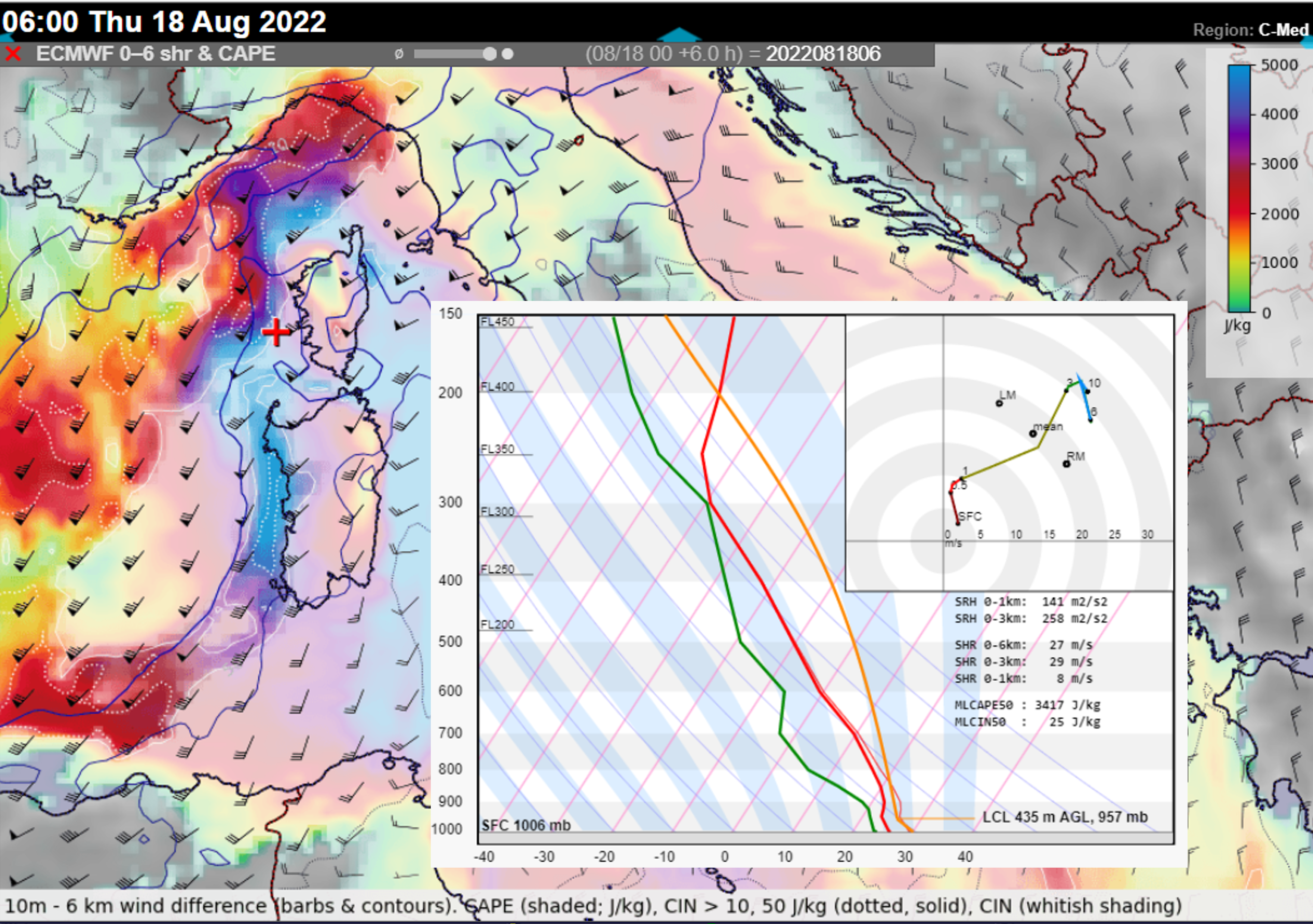
The first storms over the Balearic Sea developed in the forward flank of the trough, in the exit region of a cyclonically curved jet stream. These storms were already forming in an environment of 0-6 km bulk shear > 20 m/s and plentiful CAPE. The transformation into the bow echo occurred in an environment featuring MLCAPE > 3000 J/kg, which is extraordinarily high, and 0-3 km bulk shear > 25 m/s, conditions very favorable for intense convective windstorms.
The very high CAPE values developed due to the presence of abundant low-level moisture and steep mid-tropospheric lapse rates that had been advected from Sahara. Such pronounced overlap of CAPE and shear was present west of Corsica and between Corsica and the coastline of Tuscany. Further north and northeast, CAPE was lower, but bulk shear remained favorable for well-organised squall lines (> 15 m/s in 0-3 km layer) as far as central Austria.
ECMWF forecast of MLCAPE and 0-6 km bulk shear combined with a forecast Skew-T and hodograph for a gridpoint west of Corsica.
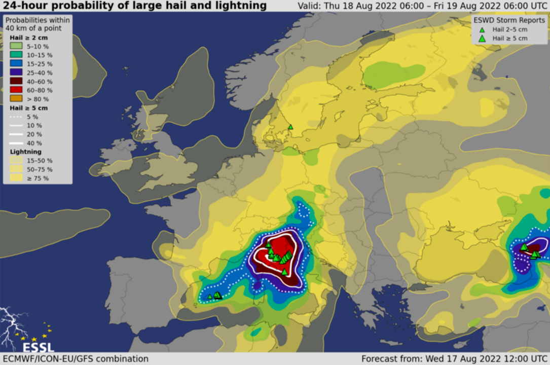
Besides the extremely severe wind gusts, the environment was very conducive for (very) large hail. ESSL’s experimental model-based forecasts AR-CHaMo predicted a large hail probability (within 40 km of a point) of over 60% in an area between Corsica, central and northeastern Italy in the 24-hour period between Thursday and Friday 06:00 UTC.
24-hour probability of large hail and lightning based on AR-CHaMo and the combination of 3 models.
While the presence of high CAPE and very strong shear helped the intense bow echo to develop, the crucial point was the upscale growth from the isolated storm to the squall line between Menorca and Corsica. We speculate that the development of the cold pool within the storm helped with the upscale growth. While the maritime boundary layer remained very moist, the presence of drier air and steep lapse rates above 900 hPa could have created strong downdrafts. Another factor may have been the mesoscale lift ahead of the progressing cold front that removed the CIN from the environment west of Corsica. The storm then tracked along the warm front towards Italy, where the further lift was provided by a warm air advection regime and a convergence zone. This lift also helped to remove the CIN from the environment. South of the warm front, CIN values were again very high, preventing convective initiation at this stage. Note that along the coast of Tuscany, vertical wind profiles would support intense tornadic supercells, but the organization of convection into a large-scale bow-echo lowered the threat of tornadoes compared to the severe wind gusts.
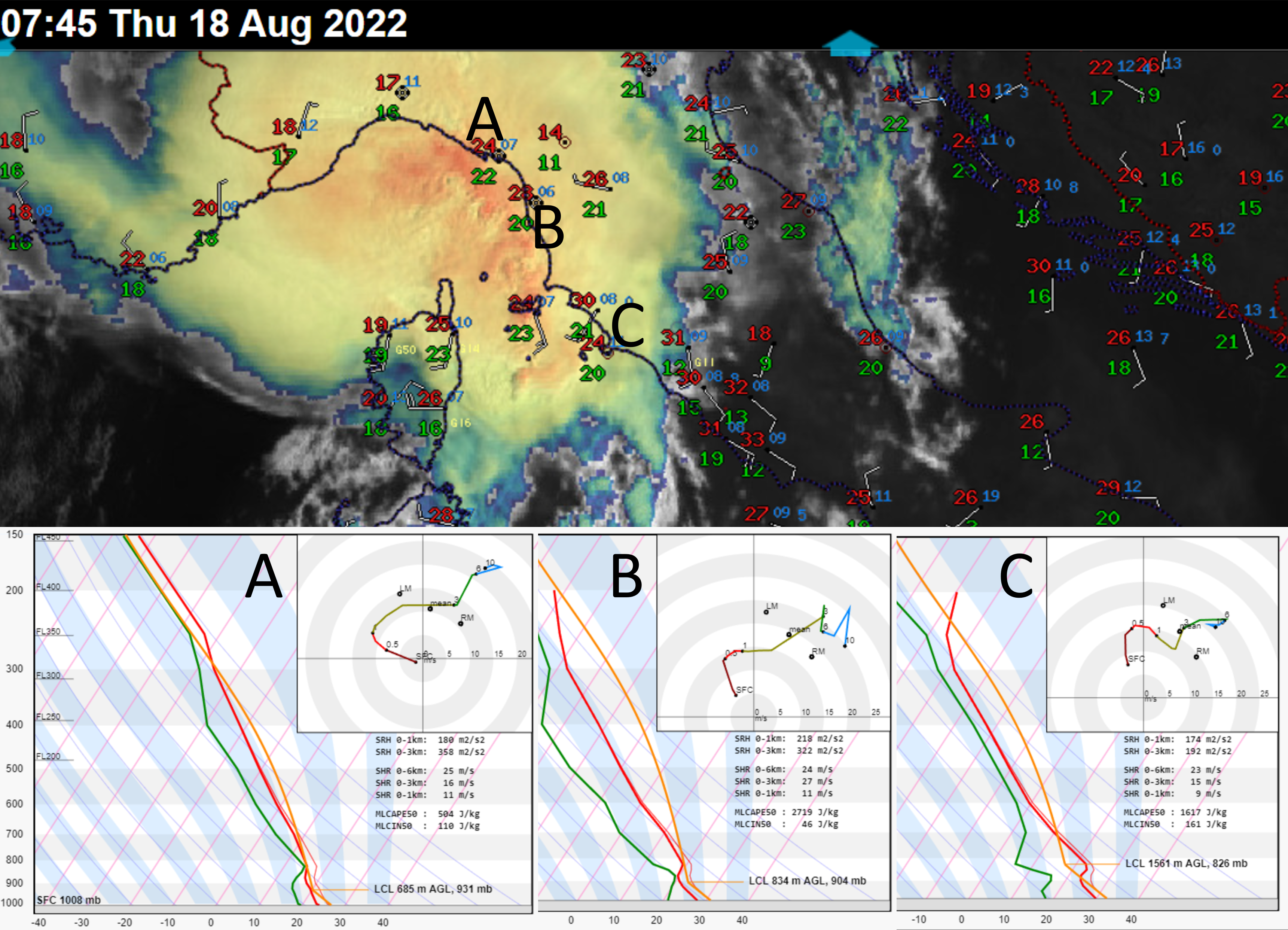
Sandwich imagery of the storm about to impact Italy at 07:45 UTC, combined with surface observations at 07:00 UTC. Positions of the three ICON-EU derived Skew-Ts are shown using the letters A, B and C. Note the temperature gradient along the warm front and the increase in CIN south of the front.
Looking at the surface observations, a cold pool was present during all stages of the derecho. The temperature of the cold pool of the storm remained constant throughout its evolution, between 20 and 21 degrees. The temperature difference between the cold pool and the surrounding environment increased as the system moved from the maritime areas further inland. Over western Corsica, the temperature decreased by 6 – 7 degrees when the gust front passed. Near the coastline of Tuscany, the temperature dropped only by 4 degrees. The temperature difference increased towards Austria and Slovenia with a drop of 9 to 13 degrees. This case shows that a strong cold pool is not necessary for a powerful convective windstorm.
The derecho went through several cycles of strengthening and weakening. By far the most impressive phase of strengthening occurred just west of Corsica as the squall line developed into a bow echo. The squall line was originally traveling towards the east. As the bow began to develop, the storm accelerated forward and its direction of movement turned more towards the north. The central part apex of the bow echo accelerated to an incredible speed of 40 – 50 m/s, compared to a mean wind of 17 m/s, which suggests the presence of a very strong rear inflow jet. The storm moved in the direction of the 0-3 km shear vector, i.e. in the direction of the strongest lift along the cold pool.
Bow-echo evolution over Corsica as shown by radar between 06:00 and 06:30 UTC. The location of the most severe wind gust is shown by the star. Source: kachelmannwetter.com, meteologix.com
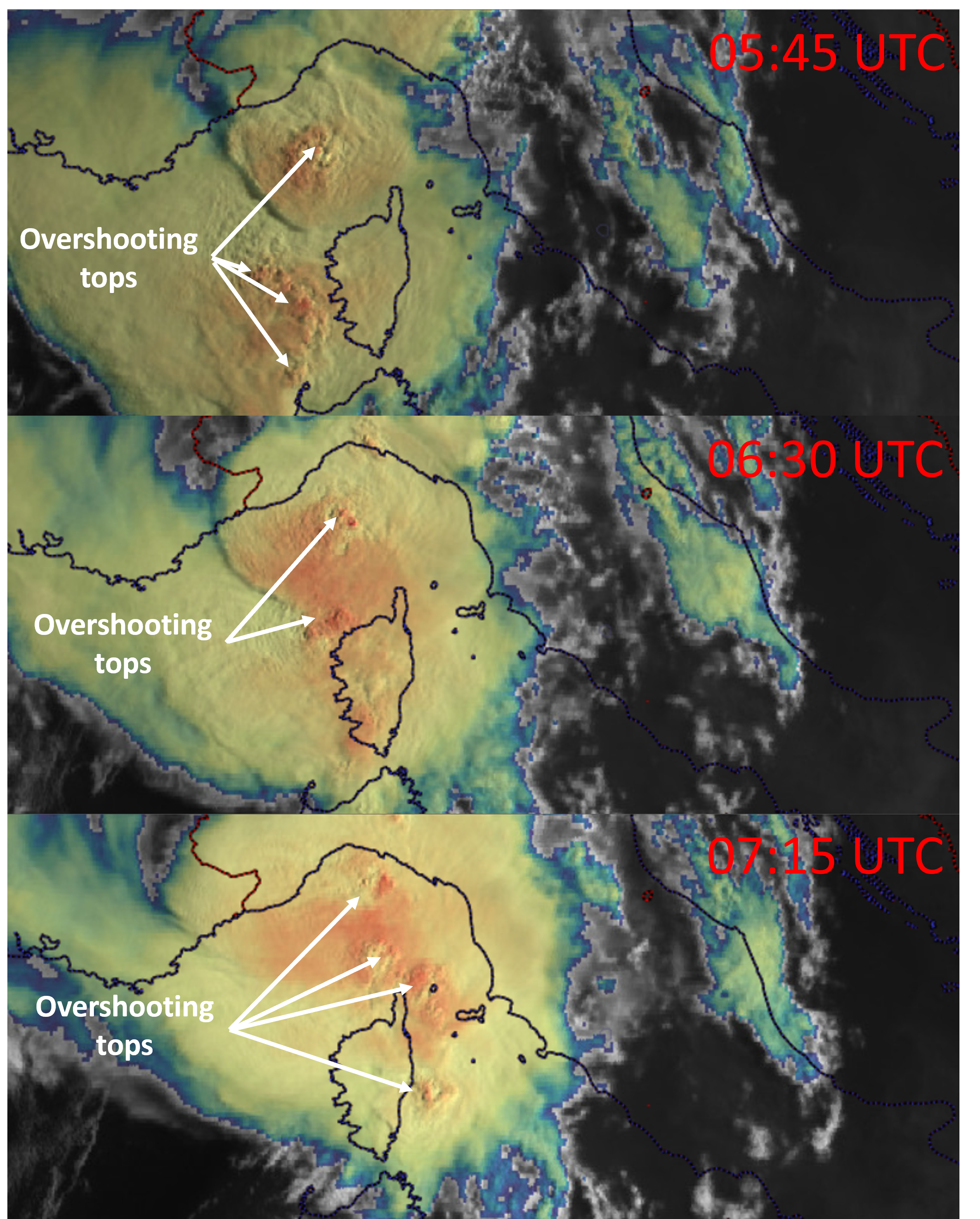
During the course of its path, the storm weakened twice as it passed the high terrain of Corsica and the Apennines. Downslope winds and perhaps lower CAPE disrupted the generation of new updrafts, which can be seen in the satellite imagery and lightning detection data.
A sequence of sandwich satellite images showing a lack of overshooting top development as the system crossed Corsica.
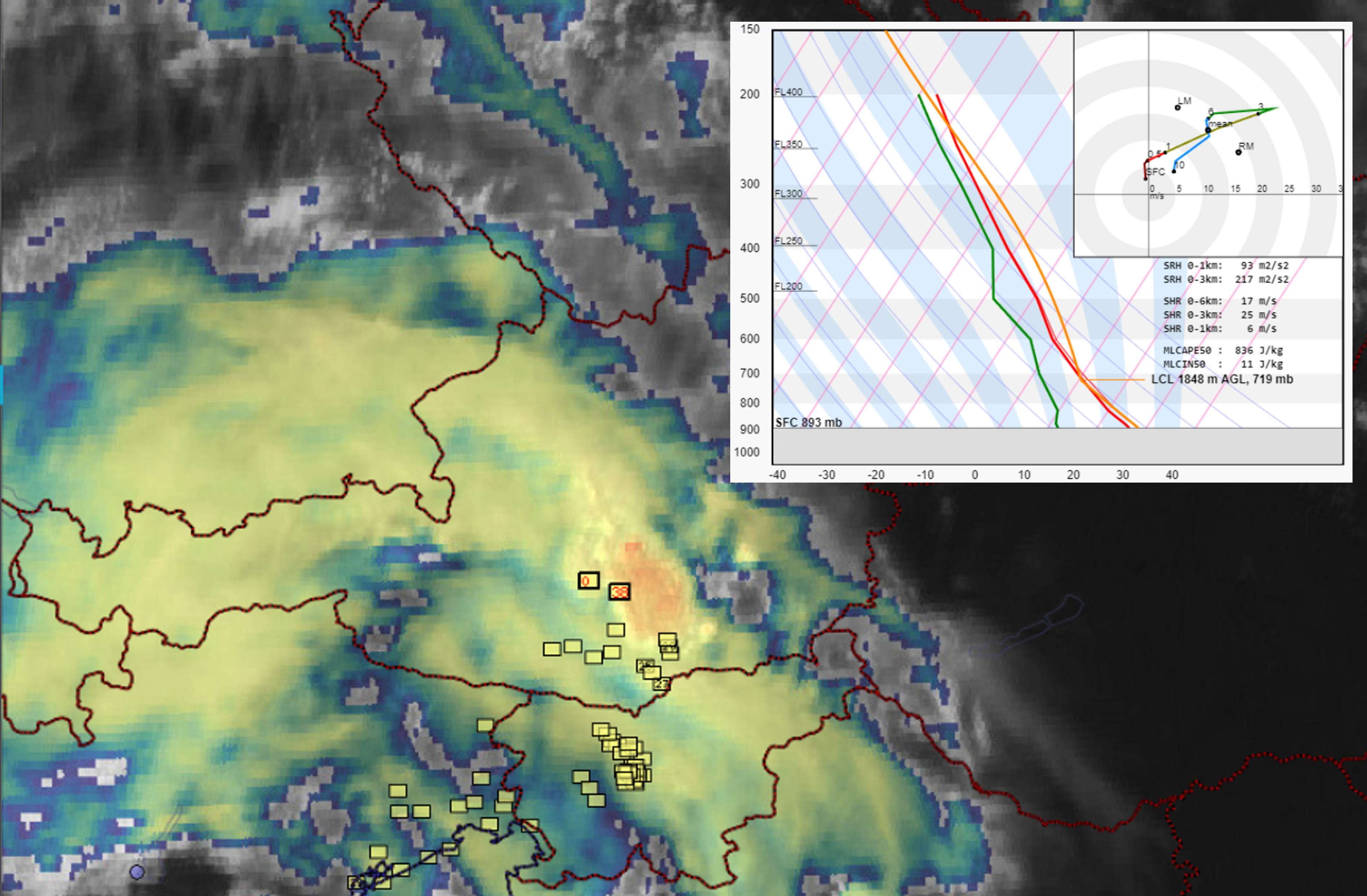
The updrafts also weakened as the system moved through northeastern Italy. Over Slovenia, numerous severe wind gusts were observed well away from the heavy precipitation cores, suggesting a persistence of the outflow. Further intensification occurred as the outflow encountered the main Alpine ridge, over which new strong cells erupted. This was followed by an intensification of severe wind gusts, reaching over 32 m/s at several stations. At this time, the environment was still characterized by 0-3 km bulk shear exceeding 20 m/s.
Sandwich imagery from 13:30 UTC shows intensifying updrafts over the Alps. Yellow squares represent severe wind gust reports based on the ESWD.
The system finally died after moving over the area of weaker 0-3 km vertical wind shear, higher LFC, and marginal CAPE over northern Austria and southern Czechia.
24 June 2022 is the first anniversary of the devastating tornado that impacted southeastern Czechia in 2021. Together with the Czech Hydrometeorological Institute and partners from other weather services and universities we have worked over the past months to process data from ground and aerial surveys that we carried out in the days after the tornado.
A 30-page report has now been published that summarizes the findings and contains information about the tornado, a detailed look at individual segments of the tornado path, and a discussion of challenges associated with the survey.
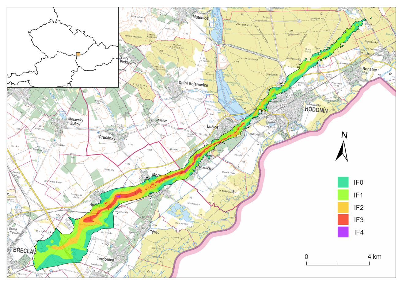
Key facts about the tornado and its damage path
Tornado formation: ~17:14 UTC, 1 km east of Břeclav Tornado decay: 17:53 UTC, 1 km south of Ratíškovice Maximum intensity: IF4 Path length: 27.1 km Maximum continuous path of IF2- or stronger winds: 15.3 km Maximum path width: ~ 2800 m, east of Břeclav* Maximum width of IF2- or stronger winds: 590 m, in Hrušky Minimum path width: ~ 250 m, in Hodonín The area impacted by the tornado: 21.9 km² The area impacted by IF2- or stronger winds: 6.1 km²
*It can not be ruled out that part of the beginning of the damage swath was caused by straight-line winds in a rear flank downdraft surge.
The European Severe Storms Laboratory calls for contributions to the mini-European Conference on Severe Storms (mini ECSS) to be held on 27 and 28 September 2022 via the online conferencing tool BlueJeans.
The pandemic situation over the past years has led to the postponement of the European Severe Storms Conference for spring 2023.
The mini ECSS, a prequel to the ECSS 2023 (Bucharest, Romania), offers an opportunity for PhD students and early-career scientists to present their latest research. This event is structured such that, for each day, there will be 10 presentations (each 15 min long) in the morning followed by 2 invited lectures (each 40 min long) in the afternoon.
Register here for the event or to submit an abstract for presentation. Those who submit an abstract are asked to provide us with a short biography.
This short blog post provides an overview of severe weather associated with the recent windstorms and discusses why the windstorm of 16 – 17 February ended up as a prolific tornado producer.
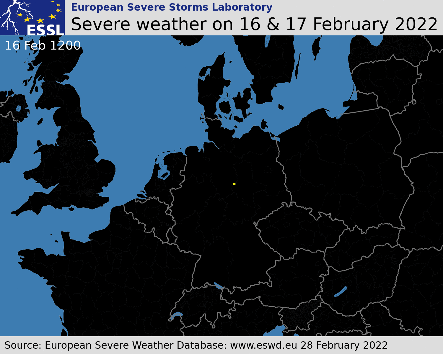
Multiple severe windstorms affected Europe in the period of 16 – 21 February. 2814 reports of severe wind gusts were submitted to the ESWD in this period, the majority of them in the belt from the British Isles through northwestern France, BENELUX, Germany into Czechia, northern Austria, and Poland. The evolution of severe weather reports for the windstorm of 16 and 17 February is shown below
Temporal evolution of severe weather reports between 16 February 12 UTC and 17 February 12 UTC. Yellow squares represent severe wind gusts and red triangles tornadoes.
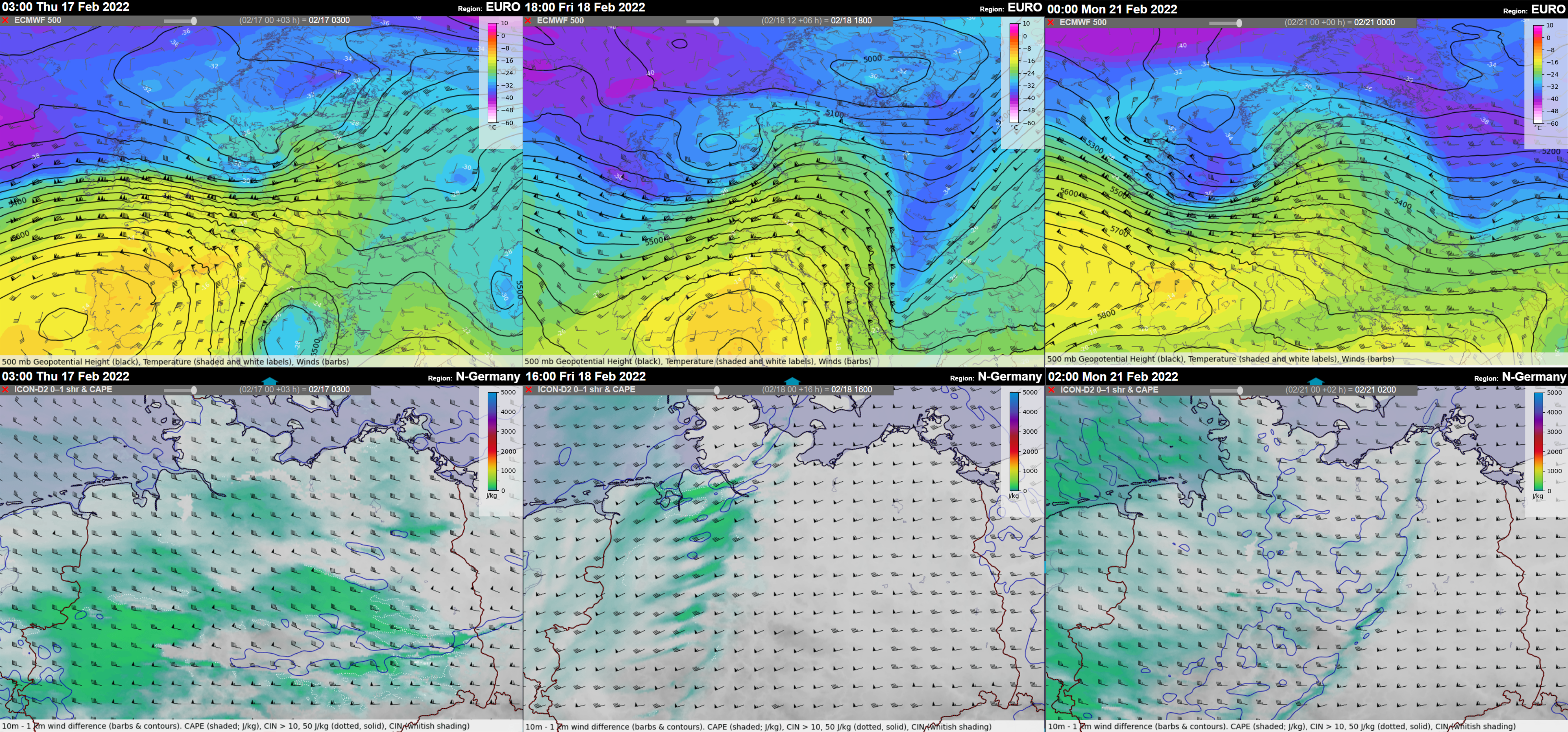
Each of the windstorms also involved a strongly-forced convective line that formed along the cold fronts ahead of the fast-moving short-wave troughs. In many areas, the passage of the convective line was accompanied by an increase in wind gusts severity. The environment featured marginal CAPE with a low Equilibrium level (suggesting low-topped storms) and strong vertical wind shear in the lower troposphere with 20 – 30 m/s of 0-1 km bulk shear. Very strong flow just above the ground explains the severity of wind gusts observed along the track of the storms.
500 hPa geopotential height, temperature, and wind (upper panel) and MLCAPE and 0-1 km bulk shear (lower panel) for 17 February, 18 February, and 21 February windstorms.
Due to the strong low-level shear, enhanced tornado threat accompanied the passage of all the windstorms. Between the night and morning hours of 17 February, a tornado outbreak occurred in a swath from northeastern Germany to south-central Poland, Malopolskie region. By 28 February, 22 tornadoes causing 2 fatalities and 5 injuries were reported in the ESWD, while further site surveys are ongoing by Skywarn Polska, and it is likely that the number of tornadoes will grow. 12 out of 22 tornadoes were strong and rated as IF2.
While the 17 February convective windstorm ended as a prolific tornado producer, the other two situations did not result in a single tornado despite a very strongly sheared environment. Overall, three windstorms occurred in this period: the 16 – 17 February windstorm (Dudley), the 18 February windstorm (Eunice), and the 20 – 21 February windstorm (Franklin). The 16 – 17 February and the 20 – 21 February windstorms featured well-organized convective systems with persistent bowing segments and inflow notches. The 18 February convective line was broken with no accompanying bowing segments.
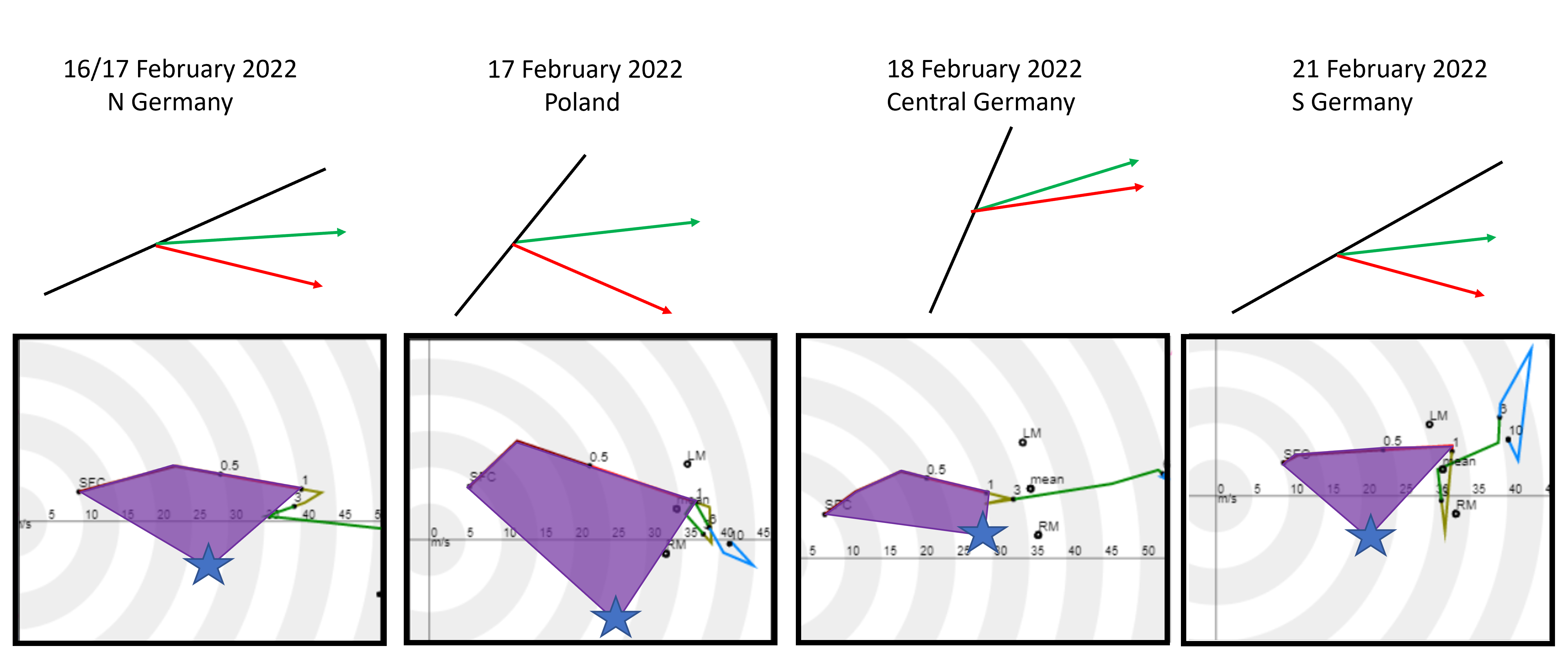
The first difference among the three situations was in the orientation of the convective line, the direction of the mean wind (green arrow), and the direction of the movement of convective elements, such as bow-echoes or inflow-notches (red arrow). In all three situations, the convective elements within the line moved to the right of the mean wind. The largest angle between the mean wind and the orientation of the convective line was noted for the 17 February windstorm over Poland, suggesting the strongest lift on the leading edge of the convective line (perpendicular being the most “favorable” configuration). The individual convective elements also deviated most from the mean wind in this case.
Relationship of convective system orientation and motion of individual elements (such as bow-echoes) to the wind profile characteristics for different cases. Upper panel: Black lines denotes the orientation of the convective system, green arrows represent the mean wind, and red arrows the direction of motion of individual convective elements. Lower panel: Hodographs with 0-1 km SRH highlighted for observed storm motion of convective elements.
Hodographs based on the ICON-DE allow us to reconstruct the storm-relative helicity available to the convective elements in different situations. Considering the observed motion of the convective elements (marked in the hodograph by blue stars), the wind profile on 17 February over Poland had by far the most SRH. The inflow into the storm would be very strong (> 20 m/s) and contain almost purely streamwise vorticity (meaning aligned with the flow, making it “helical”). Strong inflow combined with large amounts of streamwise vorticity helped to create a favorable environment for the development of strong rotation in parts of the advancing convective system.
The reason for a higher amount of helicity was a stronger southerly component of the flow compared to the other situations. This is evident both from the hodographs and the surface station measurements. As the convective line crossed Central Europe between 16 and 17 February, 10 m wind over northern Germany had a smaller southerly component than over central Poland.
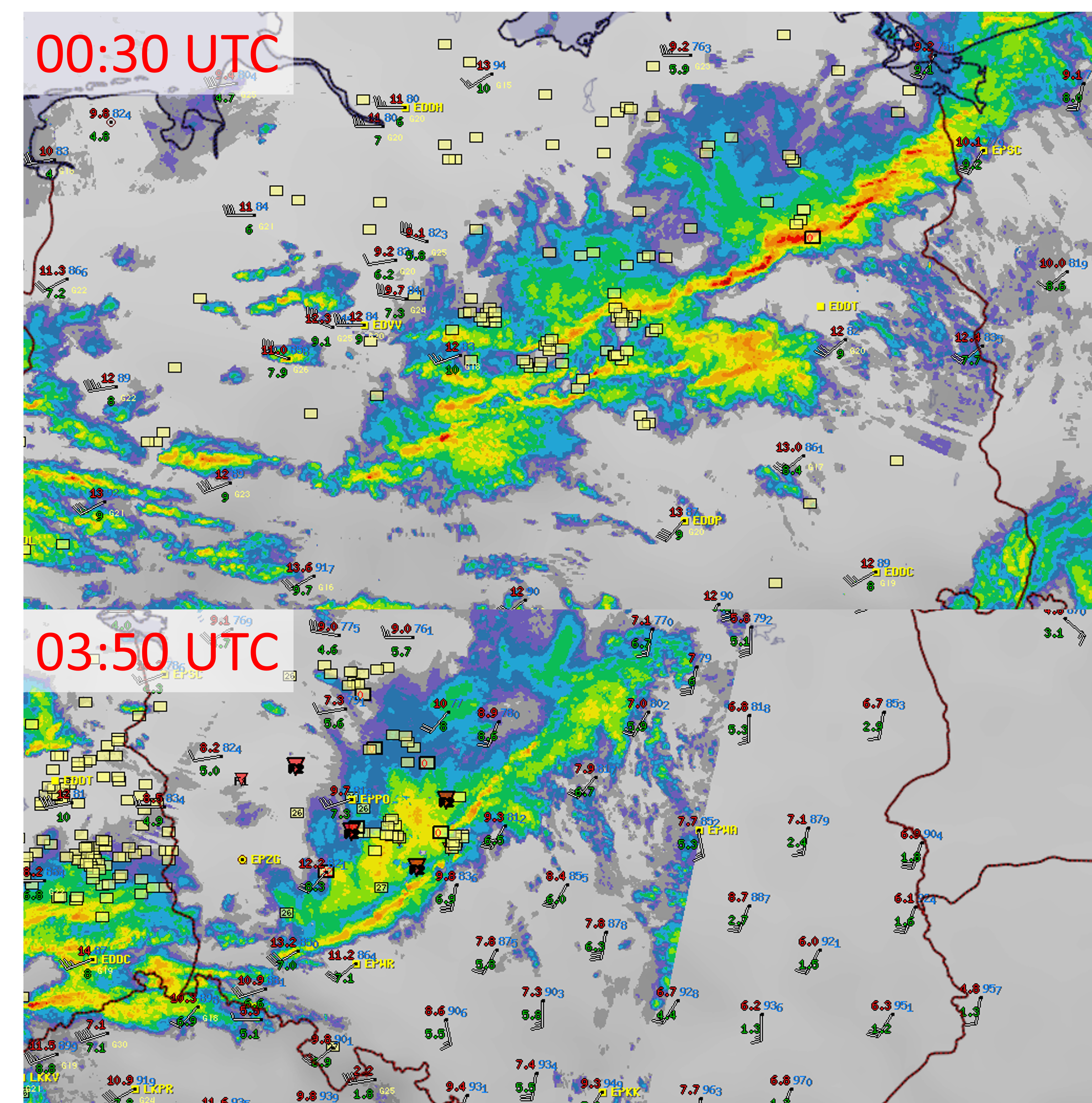
EUCom radar composite combined with surface station data (temperature and dew point shown in red and green color respectively) and ESWD reports (red triangles correspond to tornadoes and yellow squares to severe wind gusts).
The amount of helicity in the near-surface inflow seems to be the main difference between the tornado-producing convective windstorm over Poland on 17 February and the other windstorms. 17 February also had the most abundant low-level moisture content (and the highest CAPE values) as well as the line broken into many different convective elements (bow-echoes and inflow notches). Compared to the Kyrill tornado outbreak on 18 January 2007, cold pools were weaker on 17 February 2022.
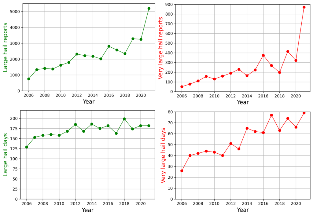
2021 was a very big year for severe hailstorms across Europe. As of 31 October, we have received 5195 reports of large (≥ 2 cm) hail, 871 reports of very large hail (≥ 5 cm), and 29 reports of giant hail (≥ 10 cm) in the European Severe Weather Database. These numbers are far greater than in the previous years. The number of very large hail reports collected in 2021 is more than twice more than the second most active year, which was 2019. By 31 July, the sum of large hail reports exceeded the sum of reports in the past years collected over the whole 12 months.
2021 does not stand out as much when looking at the number of days with large and very large hail. The inflation in the number of hail reports was caused by very large amounts of reports submitted for some individual days, such as 24 June or 8 July. Any trends in hail reports can not be used to infer the trend in the frequency of severe hailstorms in Europe due to a large number of non-meteorological factors, such as the increases in reporting rates across different countries.
A number of large and very large hail reports and days between 2006 and 2021 in the period of 1 January – 31 October.
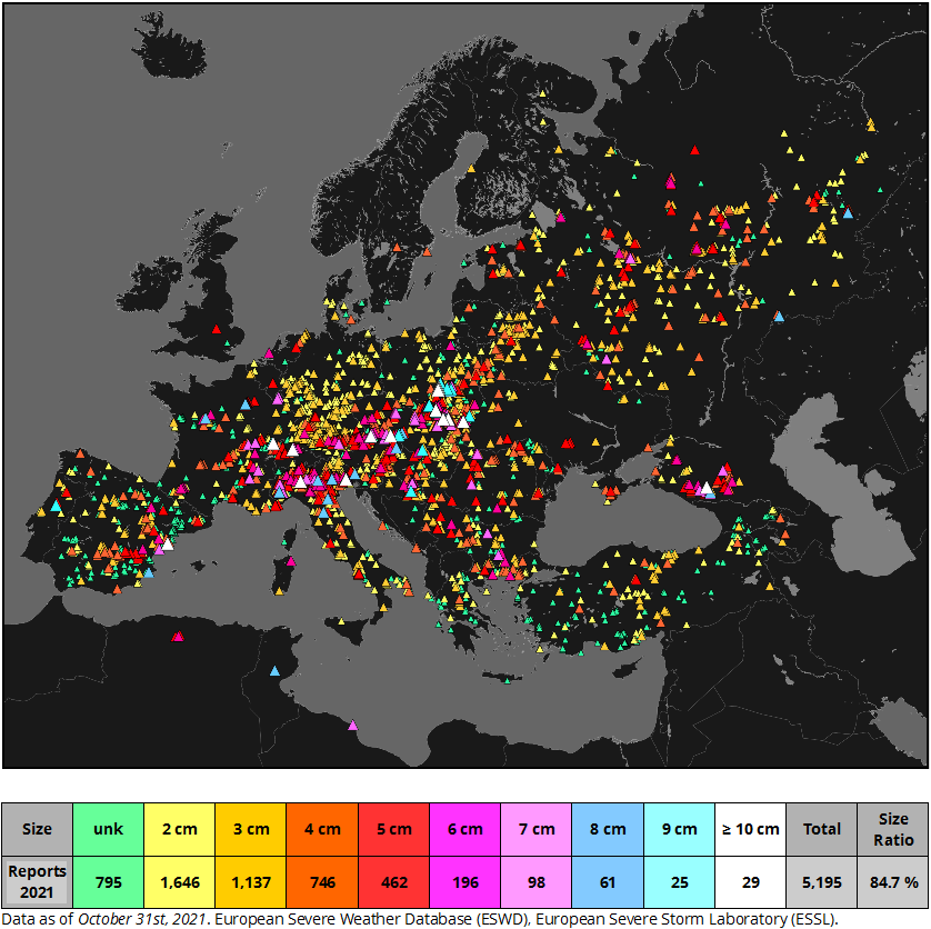
The 2021 severe hail season was particularly active in the pre-Alpine region, both on the northern (Switzerland, Austria, Germany) and southern flank (Italy), as well as across eastern Poland and southeastern Czechia. The largest hail was reported on 24 June in Poland with an estimated hail size of at least 13.5 cm. The largest number of injuries, 12, was reported from the 26 September hailstorm that hit Tuscany, Italy. 84.7% of the submitted hail reports included estimate or measurement of hail size.
Spatial and size distribution of 2021 hail reports across Europe till October 2021. Size ratio expresses the percentage of reports that include hail size.
Below you can find a selection and description of some of the most severe hail days and hailstorms in 2021. This list is non-exhaustive, so a severe hailstorm that affected your region may not be included. Red font indicates a particularly severe event. In case you feel that we have missed a particularly severe event in this list or it is not included in the ESWD, please let us know and/or submit your reports at eswd.eu!
ESSL would like to express gratitude to all voluntary observers and networks for submitting severe weather reports for their respective countries.
22 May 2021: Numerous severe hailstorms produced very large hail up to 7 cm across in Stavropolskyi Kray in Russia.
12 June 2021: Very large hail up to 9 cm across fell in the town Tábua, Portugal.
14 June 2021: 40 sheep were killed by large hail near Ankara, Turkey.
16 June 2021: Very large hail up to 6 cm across damaged numerous roofs and cars in Krasnodarskyi kraj, Russia.
19 June 2021: Severe hailstorms affected the Central, Midi-Pyrénéés, Bourgogne, Picardie and Franche-Comtéregion regions in France. The largest hail fell in Vercel-Villedieu-le-Camp with a diameter up to 10 cm, causing significant damage to cars and roofs. This was the first giant hail report in Europe in 2021. Very large hail up to 7 cm also fell in Luxembourg
20 June 2021: Very large hail was reported in the Rhone-Alpes region, France, and Luzern canton in Switzerland.
21 June 2021: Widespread area spanning a belt from southern France through Switzerland into northwestern Austria was affected by severe hailstorms. Southern suburban areas of Munich experienced hail up to 5 cm across. Severe hail damage was reported from the border area of Austria and Bavaria with the largest hail size of 6.5 cm.
22 June 2021: 7 cm hail was reported in southern Russia. Two long-tracked hailstorms affected southern Germany and northwestern Austria. Severe damage to cars from 6 cm large hail was reported from the town of Gmunden, Austria.
23 June 2021: Severe hailstorm with hail up to 7 cm across caused damage on the border of Austria and Czechia.
24 June 2021: 809 severe hail reports were submitted to the ESWD for this day, 615 of them from Poland. This day has broken the record for the maximum daily number of hail reports submitted to the ESWD, as well as the maximum daily number of hail reports submitted for a single country. Several hail-related injuries were reported to the ESWD from this day along with widespread hail damage. In some villages and towns, most roofs were damaged or destroyed by hail.
Very large hail was reported from Austria, Czechia, Slovakia and Poland. Giant hail was reported from Poland and Austria. In Poland, giant hail was observed in multiple locations with the largest hailstone, measuring at least 13.5 cm across, reported from Tomaszów Mazowiecki, breaking the national record. The largest hail fell from a left-moving supercell. In Austria, giant hail was reported in two locations with the largest hailstone falling in Hollabrunn and an estimated diameter of 12 cm. Supercell that spawned the violent tornado between Breclav and Hodonin in Czechia also produced hail up to 9 cm on the border of Czechia and Austria.
A photo of the largest hailstone of the 2021 hail season in Europe that fell in Tomaszów Mazowiecki, Poland. The lower-end estimate using a ruler in the hand of the person that took the photo was placed at 13.5 cm. Photo by Magdalena Cecotka.
25 June 2021: Severe hailstorms affected southeastern Austria, Croatia, Hungary, northern Slovakia and southern Poland. The largest 8.5 cm hailstone was reported from Czarny Potok in Poland.
28 June 2021: Very large hail was reported from Switzerland and southern Germany. 11 people were injured by hail in Switzerland and a giant, 10 cm, hail was observed in Wolhusen with significant damage to roofs, windows, and cars.
29 June 2021: Multiple severe hailstorms were reported in the Alpine area and parts of central Europe. A Hailstone of 8 cm in diameter was photographed in Tarcento, Italy.
30 June 2021:Very large hail up to 7 cm fell in northern Slovakia. A long track hailstorm across southern Poland produced giant hail up to 11.5 cm that weighed up to 200 g.
1 July 2021: Very large hail up to 7 cm across reported in Bulgaria.
8 July 2021: Very large hail was reported in Italy, Switzerland and Czechia. 169 large hail reports were submitted to the ESWD from Italy. The largest hail, 11 cm in diameter, fell in Rozanno, on the southwestern outskirts of Milan.
Very large to giant hailstones in Rozanno, Italy on 8 July 2021. Image source: Tornado in Italia (author unknown)
9 July 2021: Very large to giant hail was reported from Croatia (up to 9 cm across), Hungary (up to 9 cm across) and Poland (up to 11 cm across). The largest hail across Poland was again produced by a left-moving supercell.
13 July 2021: Very large hail was reported from northern Italy (up to 7 cm in diameter) and southwestern Czechia (up to 6 cm in diameter).
14 July 2021: Very large hail up to 8 cm in diameter was reported from eastern Austria in the early morning hours.
15 July 2021: Very large hail was reported in Serbia and Romania (up to 7 cm in diameter).
25 July 2021: Very large hail, up to 8 cm in diameter, observed in Lombardia.
26 July 2021: Several long-tracked hailstorms formed over southern Germany and northern Italy. The largest hailstone reached 8 cm in diameter. One of the hailstorms crossed the highway near Parma, severely damaging hundreds of cars that were undrivable afterward. Minor injuries were also reported. Very large hail was also reported in Austria and Poland.
Examples of damage inflicted by wind-driven hail on 26 July 2021. Photos were taken by Rosella Rotelli and inmeteo.net.
30 July 2021: Very large hail up to 7 cm across damaged roofs in Rochefort-Samson, France.
31 July 2021: Numerous severe hailstorms occurred in eastern Spain and northern Italy. Giant hail up to 10 cm across fell in Peñíscola, the Valenciana region of Spain. In Italy, the largest hail fell in Piemonte with a diameter up to 8 cm across multiple locations.
1 August 2021: An early morning hailstorm produced giant hail up to 11 cm in diameter in Azzano Decino, Friuli-Venezia Guilia region of Italy. Serious damage to roofs and cars was reported. In the afternoon, very large hail was observed in Romania.
15 August 2021: Severe hailstorms formed over eastern France, southern Germany and eastern Slovakia. Maximum hail size reached 6 cm.
23 August 2021: Very large hail up to 8 cm in diameter was reported from southern Russia.
18 September 2021: Damaging hailstorm affected Tivat, Montenegro in the morning hours. Large hail caused significant damage to windows, cars, and crops
26 September 2021: 12 people were injured by very large hail in Vaglia, Tuscany. Significant damage was done to cars, roofs, windows, and crops.
ESSL is delighted to announce that it has entered into a contract with EUMETSAT for three years to train forecasters of the national (hydro-)meteorological services of its member states. The training focuses on the use of products from the next-generation satellite missions Meteosat Third Generation (MTG) and EUMETSAT Polar System–Second Generation (EPS-SG) for the analysis and nowcasting of severe convective storms.
EUMETSAT and ESSL have started this contract on 1 June 2021 that is intended to pave the way for longer-term collaboration in support of the European meteorological community.
ESSL will organize training testbeds for operational forecasters of Europe’s weather services, introducing proxy, and later real, data from EUMETSAT’s next-generation missions with a focus on severe convective storm forecasting. The aim is to totally train about 10–15% of the operational meteorological workforce in European weather services, or about 200–300 forecasters.
The testbeds will mainly be organized at ESSL’s Research and Training Centre in Wiener Neustadt (Austria), but can also be hosted by weather services with suitable facilities upon their request. Optionally, testbeds can be held online as well.
Besides the testbeds, expert workshops will be organized for a small number of people that include senior forecasters, product experts, senior trainers, science-to-operations staff, and experts from EUMETSAT. The aim of these workshops is to better understand novel capabilities for severe storm analysis and prediction, such as with the new 0.9 mm and 2.25 mm bands, the Lightning Imager, and the Infrared Sounder, and to develop training concepts and material. The first such workshop will be planned during the first months of 2022.
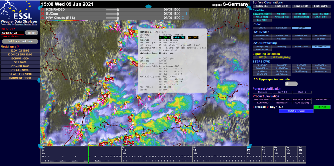
10th edition of the ESSL Testbed is upon us and will be held in four weeks: 14–18 June, 21–25 June, 5–9 July and 12–16 July. The second and third weeks are for invited experts, or participants who have already been to the Testbed before or other courses. Like last year, the Testbed will be held online. 44 participants have registered, 12 people for the regular and 10 for the expert weeks.
Compared to 2020, there are a few new aspects. First, we have improved our WeatherData Displayer, which has a new, darker layout, and now allows a smoother switching between different regions. Moreover, a transparency option for data layers has been added. There is also more NWP data in the displayer compared to last year, including ensemble output from ICON-D2 (DWD) and C-LAEF (ZAMG). The third convection allowing model is Harmonie (KNMI). A large part of the data processing is now done in the European Weather Cloud, with thanks to ECMWF.
Besides daily forecasts of convective storms, we are going to evaluate new tools developed for forecasting and nowcasting of convective storms. This year we will concentrate on:
Extreme Forecast Index and Shift of Tails for CAPE and CAPE-shear from ECMWF
C-LAEF ensemble prediction system from ZAMG
ICON-D2 ensemble prediction system from DWD
Modified Lightning Potential Index from DWD
KONRAD3D cell-tracking nowcasting tool from DWD
STEPS-DWD radar nowcasting tool from DWD
NowcastSAT satellite nowcasting tool from DWD
We are looking forward to all the participants and interesting discussions on these new products and the hopefully interesting weather situations!
We welcome external persons to join the daily Testbed weather briefings from Tuesday through Friday during Testbed weeks starting at 11:00 CEST (0900 UTC) until approximately 12:30 CEST (1030 UTC). To join, visit this link: https://bluejeans.com/720241930
The European Severe Storms Laboratory (ESSL, https://essl.org) is looking for a
Researcher (75 – 100 %) for two years initially
based
in Germany, to support its work in the research project CHECC on severe
thunderstorms and climate change (see below) at 75% of a full position.
Optionally,
other tasks involving programming work in support of the ESSL Testbeds may be
taken over. In this case, the researcher can be hired full-time. We are looking
for someone who can start in the coming months, or at the latest by September
2021.
CHECC
We are looking for support of the project “Convective Hazard Evolution under Climate Change” (CHECC, see: https://www.essl.org/cms/checc/), part of the German research programme ClimXtreme (see: https://www.climxtreme.net/) which includes several research groups at various universities. The primary goal of CHECC is to find out if effects of climate change on the occurrence of (severe) thunderstorms in Europe can be detected in reanalyses and climate models. This is done by developing and applying statistical methods with a strong basis in physics. Tasks of the researcher will include:
Evaluating
the role of changes in synoptic scale weather patterns on severe thunderstorm
probability
Evaluating
changes in the variability of weather conditions supportive of severe
thunderstorms
Reporting
on the research in peer-reviewed scientific journals
ESSL
Testbed
The
ESSL Testbed is a collection of one-week events, which (in non-corona times)
takes place in person at ESSL premises in Wiener Neustadt, Austria. There,
forecasters and developers work together to evaluate novel products developed
to support the forecasting and warning process. They do this by using these
products based on satellite, radar, and numerical weather prediction data to
make forecasts in a quasi-operational setting. ESSL seeks someone to help
develop and maintain the ESSL Weather Data Displayer, which is an interactive
web page for displaying meteorological data.
Profile
The
employee needs to be a resident in or moving to Germany as this is a
prerequisite by the funder of the CHECC project. The current ESSL team is
spread across many European countries including Germany, Austria, the
Netherlands, Romania, and Croatia and often works remotely. The employee do
their work through teleworking from Germany. In collaboration with the
Institute of Meteorology of the Freie Universität Berlin, we offer a workplace
at the Institute, which is the location of the other current ESSL CHECC
researcher. It is expected that the new employee will coordinate with him and
with other ESSL colleagues in weekly video meetings and will meet in person
approximately every two to three months, in Berlin, Wiener Neustadt, or another
agreed location. In case work in support of the ESSL Testbed is done, it is
expected that the employee will take part in person in the Testbed in Wiener
Neustadt for at least one week in June and/or July.
ESSL
offers this position for a two-year period, limited by the duration of the
funding for the CHECC project. Provided that subsequent funding is found, the
employment may be continued beyond the two-year period, and could be made
permanent. As a researcher at ESSL, you will be part of a small international
team of ESSL which has become an important centre of competence in Europe with
regard to severe convection. You will be able to contribute to the various
other activities carried out and take part in ESSL courses taught by experts in
the field.
We are looking for a person who has a Master or Ph.D. degree or equivalent in meteorology, physics, or a related discipline, who is enthusiastic about severe weather research. A well-organized, reliable, and communicative character is expected. For graduates of a Master’s degree, the work done for the CHECC project can be part of a Ph.D. degree (dr. rer. nat.) pursued at the Freie Universität Berlin or another university.
We require:
Good
command of the English language in speaking and writing
An
M.Sc. or Ph.D. degree in physics, meteorology, geophysics, mathematics or
similar
An
interest in (severe) convective storms
Experience
with programming using languages such as Python, R, or similar
Beneficial, but
not essential, are:
Having
published in peer-reviewed literature
Having
done prior research work related to atmospheric circulation patterns
Knowledge
of the German language or willingness to learn German
Some
knowledge of web-programming (HTML, PHP, JavaScript)
An
interest in weather forecasting
The salary level
is oriented at the German TvöD salary table, level E 13. In case the employee
with carry out the research work (at 75%), an indicative net salary is around €
2000/month, depending on the applicable tax class according to German law and
other factors. In case the employee will
also contribute to the Testbed and work full time (100%), an indicative net
salary is € 2500/month.
With reference
to ESSL’s diversity policy, we especially encourage women and minorities to
apply. We are looking forward to receiving your application including a
motivation letter and a curriculum vitae until February 28th 2021 by
e-mail to Pieter Groenemeijer: pieter.groenemeijer@essl.org.