Mini ECSS is around the corner and you can find the latest information about it here! The conference is held online on 27 and 28September. On both days the program will start with student presentations at 9 AM CEST (7 UTC) and there will be two invited talks each day starting at 2 PM CEST (12 UTC). In case you forgot, there is still a chance today (i.e. 26 September) to register to attend the conference!
All registered participants will be sent a link to the Bluejeans that we will use for the conference. The program can be found below or downloaded.
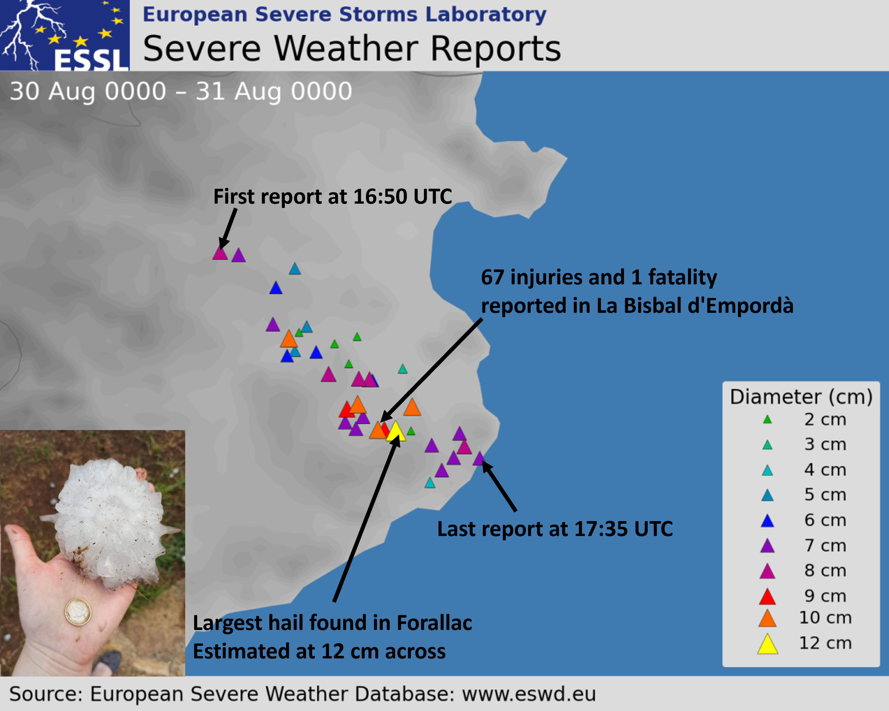
In the late afternoon of 30 August 2022, an extraordinary supercell storm formed over the eastern Pyrenees. The storm quickly started to move to the right of the mean wind as it entered the district of Girona in Catalonia, producing a swath of very large hail (≥ 5 cm) between Esponnellá at 16:50 UTC and Tamariu at 17:34 UTC, after which it moved over the sea.
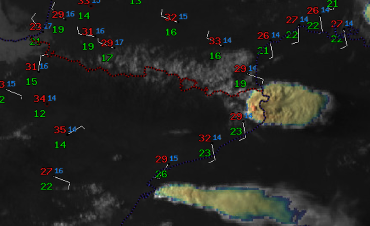
Sandwich satellite image of the hailstorm over Northeast Catalonia on 30 August 2022 at 17:30 UTC, and surface station measurements of the wind, temperature (red), and dew point (green).
Multiple reports of hailstones larger than 10 cm in diameter were collected with the largest stones estimated to be 12 cm. Based on some videos, the hail fall was relatively dense for stones of that size. The impacts of the storm were high: Besides serious damage to roofs and cars, 67 injuries and even one fatality resulted in the town of La Bisbal d’Empordà. 28 people had to be taken to the hospital, including one serious head injury. Based on our study on hail impacts across Europe, this was the first direct hail fatality in Europe since 1997. Furthermore, the number of injuries ranks as the third highest recorded in the ESWD for large hail events.
Given the societal and economic impact of this hailstorm and the fact that the giant hail has already been reported 18 times in Europe this year, we look at the predictability of this particular event from the perspective of the large-scale, pre-convective environment addressing these two questions:
How likely was the convective initiation?
How likely were the initiated storms to produce giant hail?
Limiting ourselves to the large-scale environment we do not address two important sources of data: high-resolution convection-allowing models and nowcasting data, such as products based on radar
How likely was the convective initiation?
With an abundance of low-level moisture along the coastline and steep mid-tropospheric lapse rates advected from the interior of Iberia, high convective available potential energy (CAPE) was present to support the development of severe thunderstorms.
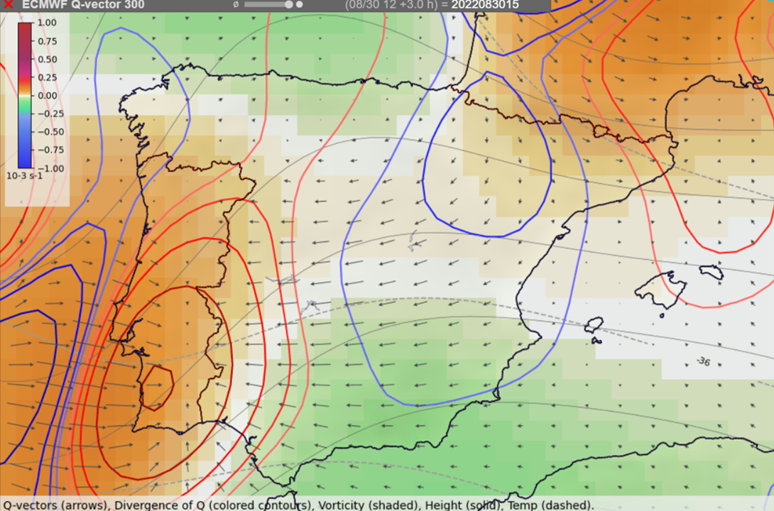
With this potential being present, the most important question was if a trigger strong enough to set this energy free would be available in this environment. The synoptic-scale lift was forecast only over extreme northeastern Spain and in the upper troposphere near 300 hPa, but not at lower levels. With the absence of fronts or other large-scale air-mass boundaries, the mesoscale lift had to come from an upslope flow of maritime air against the high terrain.
Locations of where large-scale upward (red contours) and downward (blue contours) vertical motion is to be expected based on Q-vectors at the 300 hPa pressure level.
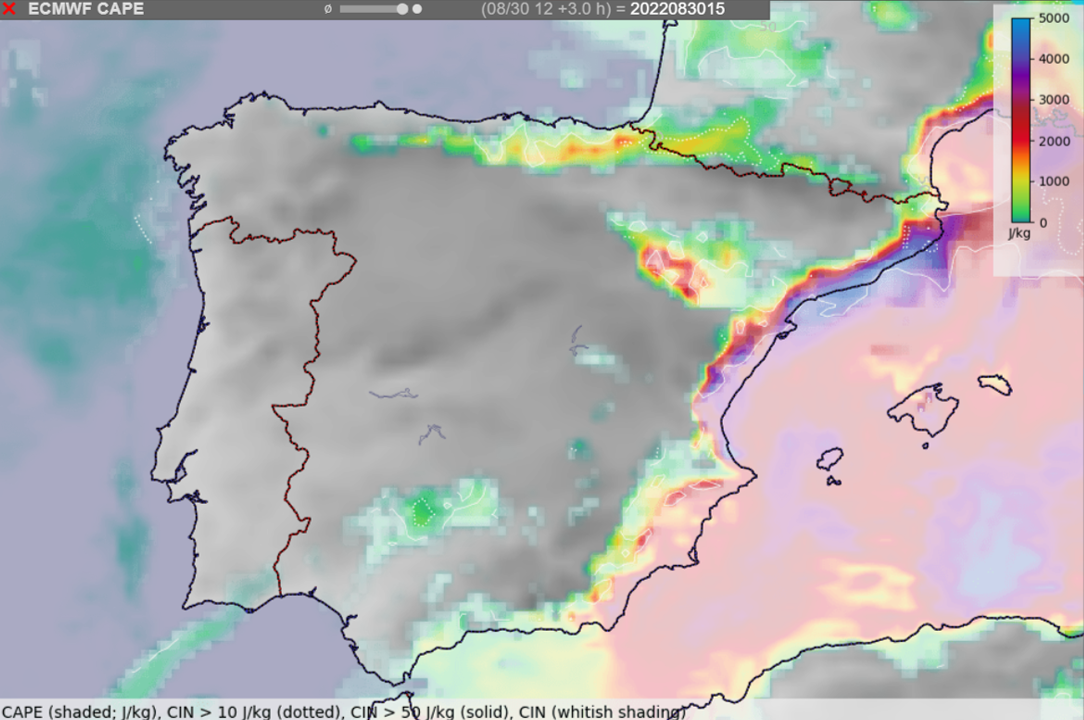
Convective initiation across Spain was complicated by a substantial amount of convective inhibition (CIN), negative energy to be overcome before a storm can form, especially over the southern part of Iberia. Near the eastern coastline, CIN rapidly increased from the mountains towards the coastline, restricting the ability of the storms to tap into the moisture- and CAPE-rich air mass. The largest area of relatively low CIN (< 50 J/kg) existed over far northeast Iberia, where the supercell formed.
Combining the lowest CIN and the presence of at least some synoptic-scale lift over far northeast Spain, with hindsight it is possible to pinpoint this area as one with the highest probability of storm formation. Severe hailstorms are often isolated cells, rather than storms which are embedded in a larger convective system. On the 30 of August, the absence of widespread mesoscale lift and the presence of some CIN in the environment probably helped to limit the number of storms that formed to the one storm that produced the giant hail.
While it is easy to retrospectively explain the isolated nature of the storms on this day, beforehand it was not possible to state with certainty what will be the exact track of the storms or whether there will be three or no storms at all.
Forecast of the ECMWF IFS model of CAPE (colors) and areas of convective inhibition (whitish shading) at 15:00 UTC.
How likely were the storms to produce giant hail?
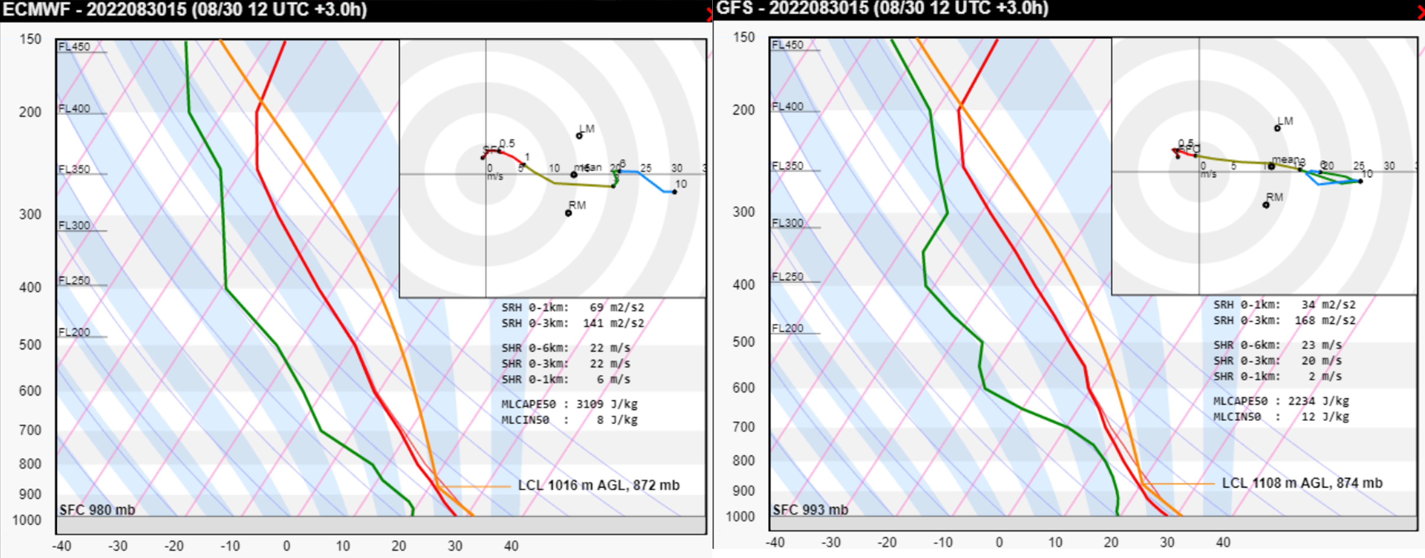
The supercell moved into the environment that has been found to be very conducive to severe weather, featuring high CAPE and strong vertical wind shear. Considering the model-simulated Skew-T and the surface observations from the area (temperature of 29, dewpoint of 23°C, and 5 m/s SSE wind), very large hail production was supported by:
High values of CAPE (MLCAPE ≈ 4000 J/kg) with large amounts of CAPE found in the temperature zone < -10°C
Vertical wind shear supportive of supercells. Very large hail occurs almost exclusively with this type of convection. Furthermore, strong shear resulted in a strong inflow into the storm. Based on the simulated hodograph, observed surface wind and observed storm motion, the surface inflow into the storm was almost 20 m/s. Strong inflow supports wide updrafts and wide updrafts lead to long hail embryo residence times in the favorable growth zone.
Unidirectional vertical wind shear (i.e. straight hodograph). Straight hodographs have been found to be more conducive to large hail growth than curved hodographs.
Both low-level shear and storm-relative helicity were quite weak in this case. Unlike for tornadoes, high values of these parameters are not necessary for very large or even giant hail.
ICON-EU forecast of CAPE, 0-6 km bulk shear at 15 UTC with the model Skew-T and hodograph for the location represented by the red cross. The red star within the hodograph marks the observed surface wind and the blue star the observed storm motion. The black arrow is the surface storm-relative wind (i.e. inflow at that level).ECMWF and GFS forecast soundings for 15 UTC. Note the underestimation of surface dewpoint.
Supercell also profited from being the only storm around with no disruption to its inflow and updraft. Its deviant motion to the right was also more pronounced than anticipated by the Bunker’s ID method, suggesting the presence of a strong mesocyclone.
Was it possible to make a confident forecast of the storm producing hail reaching 10 cm? Such a forecast would be useful, as 10+ cm hailstones have a higher probability of causing both damage and injuries compared to 5+ cm hailstones. However, hail diameter doesn’t linearly increase with increasing CAPE and shear. For example, increasing CAPE may even limit the large hail production beyond some point. There are likely other factors that influence the trajectory of hail embryos through the updraft and their residence time in a zone of abundant super-cooled water droplets. Some of these are covered in a lecture by Matthew Kumjian. Testing these factors against a large sample of very large or giant hail cases will perhaps bring us even closer to confident forecasts of such devastating hailstorms.
In conclusion, the combination of very favorable large-scale conditions for hail with isolated convective initiation resulted in a perfect scenario for a damaging hailstorm. Such knowledge provided a good chance to correctly nowcast the event once the storm entered a supercell stage.