
Tornado forecasting can be very challenging, especially in low CAPE – high shear environments and when lower tropospheric shear is only locally enhanced. Such was the case of an F1 tornado that hit the village of Lekárovce in eastern Slovakia on 3 October 2018. This tornado is the main subject of a paper “A Challenging Tornado Forecast in Slovakia” that has been recently published in the journal Atmosphere. The study was led by Miroslav Šinger from Comenius University and Slovak Hydrometeorological Institute in Bratislava and co-authored by Tomáš Púčik from ESSL.

Authors of the study attempted to reconstruct the environment leading up to the tornado based on the observational datasets and compared it with the model data that was available to forecasters in the morning hours before the tornado. One of the main aims of the paper was to show whether observational data or the higher resolution run of the local model would improve the ability to identify conditions favourable for tornadogenesis.
Tornado occurred in the early afternoon hours underneath strong west-northwesterly mid to upper tropospheric flow at the flank of a deep low-pressure system. Enhanced lower tropospheric moisture combined with mid-tropospheric lapse rates of 6.5 K/km allowed for a build-up of marginal CAPE reaching 200 – 300 J/kg.
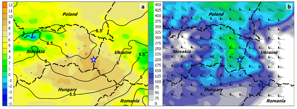
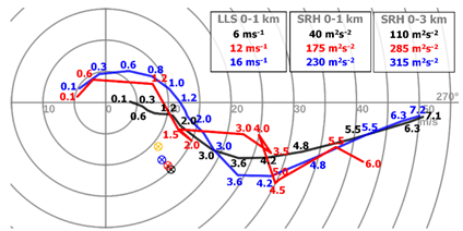
But while the deep-layer shear was very strong, models predicted a decrease in 0-1 km shear between morning and early afternoon hours with surface wind veering from East to West. However, easterly wind direction persisted over eastern Slovakia for much longer, yielding strong lower-tropospheric shear as the storms developed in the afternoon. Study shows that using both observational datasets and the higher resolution version of the local area model would alert the forecaster to the presence of strong lower tropospheric shear over the area of interest.
More details can be found here: Šinger, M.; Púčik, T. A Challenging Tornado Forecast in Slovakia. Atmosphere 2020, 11, 821.
