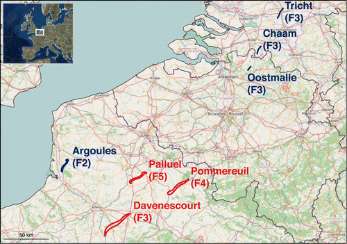
The tornado outbreak of 24–25 June 1967 remains the second deadliest tornado outbreak over Europe since 1950 after the tornado outbreak of 9 June 1984 over Russia. Over the course of two days, one F2 tornado, four F3 tornadoes, one F4 tornado, and one F5 tornado struck France, Belgium and Holland (Fig. 1), resulting in 15 fatalities and 234 injuries.
Figure 1. Tornado tracks from 24 (red) and 25 (blue colour) June 1967.
In a study from 2018, a team led by Bogdan Antonescu looked at the details of the outbreak and at what would be the consequences if a similar tornado outbreak will occur 50 years later (i.e., 2017). This was done by transposing the seven tornado tracks from the June 1967 outbreak over the modern landscape. Due to urban growth, it is possible that tornadoes could cause even more impact than in 1967. Based on the statistics of fatality and injury rates associated with European extracted from the European Severe Weather Database, a similar tornado outbreak with the one that occurred in 1967, would result in 55–2580 injuries, and 17–172 fatalities. In the worst-case scenario, with tornado tracks moving over highly populated areas over the region, up to 146 222 buildings could be impacted with 2550–25 440 injuries and 170–1696 fatalities. This study clearly shows how impactful such a tornado outbreak could be to society.
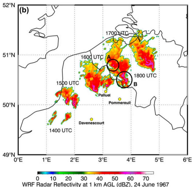
A follow-up study that has just been published in Weather and Forecasting (link) hindcasts the tornado outbreak using an WRF-ARW simulation, with initial and boundary conditions provided by ERA-40 reanalysis and the highest-resolution domain with 800-m grid spacing. The model simulated an environment conducive for tornadic supercells with CAPE exceeding 2000 J/kg, 0–6 km bulk shear between 20–25 m/s and Storm Relative Helicity reaching 300 m²/s² in the 0–3-km layer. The model was also able to explicitly simulate a number of supercells over the region of interest (Fig. 2).
Figure 2. Timestamps of radar reflectivity echo at 14, 15, 16 and 17 UTC on 24 June 1967.
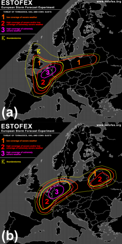
One of the questions posed by the article is how would a forecast of such an event look like today? To do this, an ESTOFEX forecaster was presented with a set of forecast maps for both days (without knowing the dates) and asked to provide Day-1 outlooks. The forecaster issued Level 3 (the highest risk of severe weather) for both days, on (Fig. 3). This paper demonstrates that, with our understanding of severe convective storms and state-of-the-art numerical modelling, a forecast of a tornado outbreak over Europe is possible. Given how much societal impact significant tornadoes can cause, addressing their threat should be part of any convective storm forecast.
Figure 3. ESTOFEX hindcast outlooks for a) 24 June 1967 and b) 25 June 1967.
Full versions of both studies can be freely accessed here:
In the beginning of January, we published a series of posts on social media about severe weather in 2019. This blog puts together this information and graphics, and provides an overview of the most prominent severe weather events of the year.
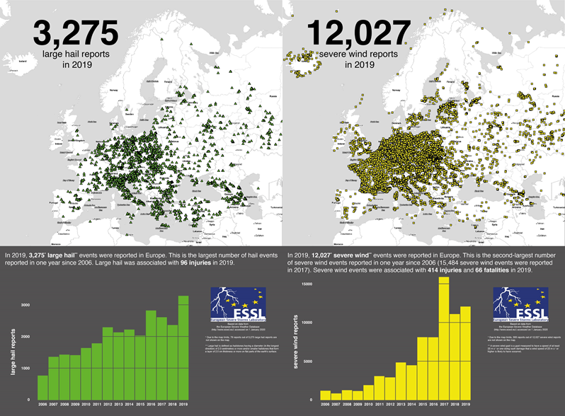
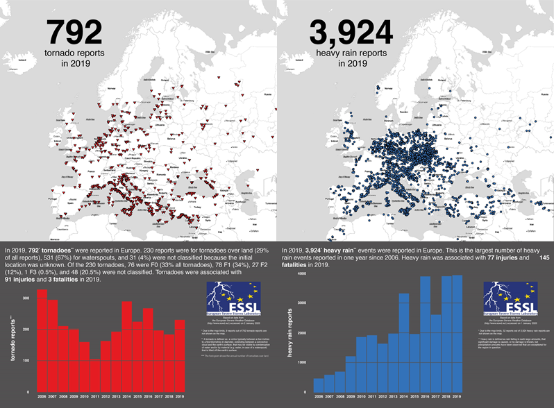
2019 was a comparatively active severe weather year. ESSL received 3275 reports of large hail as well as 12 027 severe wind gust reports, 792 reports of tornadoes and 3924 of heavy rain. This year has the highest number of large hail and heavy rain reports since the ESWD was established in 2006, and it was exceptional especially regarding the large hail. For example, more than 96 hail-related injuries were reported with 15 hail events, while hail injuries were reported only 96 times in the whole history of the database. In addition, 14 events included giant hail, reaching or exceeding the size of 10 cm. Further fatalities and injuries were reported with severe wind gusts: 66 and 414, respectively.
An overview of large hail and severe wind gust reports across Europe in 2019.
Tornadoes caused 3 fatalities and 97 injuries and were reported mostly near the coasts of the Mediterranean Sea. 531 out of 792 tornadoes occurred exclusively over water, and can thus be called waterspouts. There were 28 strong tornadoes during the year, of which 27 were rated F2 and 1 F3. Heavy rain caused 145 fatalities and 77 injuries. Most of the reports came from Central Europe and from Italy.
An overview of tornado and heavy rain reports across Europe in 2019.
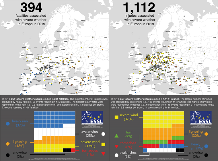
In total, severe weather killed 394 people and 1112 people were injured during 2019. Most of the fatalities were attributable to heavy rainfall, followed by avalanches and lightning. Most of the injuries were caused by severe wind gusts, followed by lightning and hail. While heavy rain comprised 37% of all fatalities, it contributed to only 7% of injuries. Tornadoes caused about 1% of fatalities and 8% of injuries. This shows how differently the impact of severe weather phenomena can be.
Severe weather related fatalites and injures across Europe in 2019.
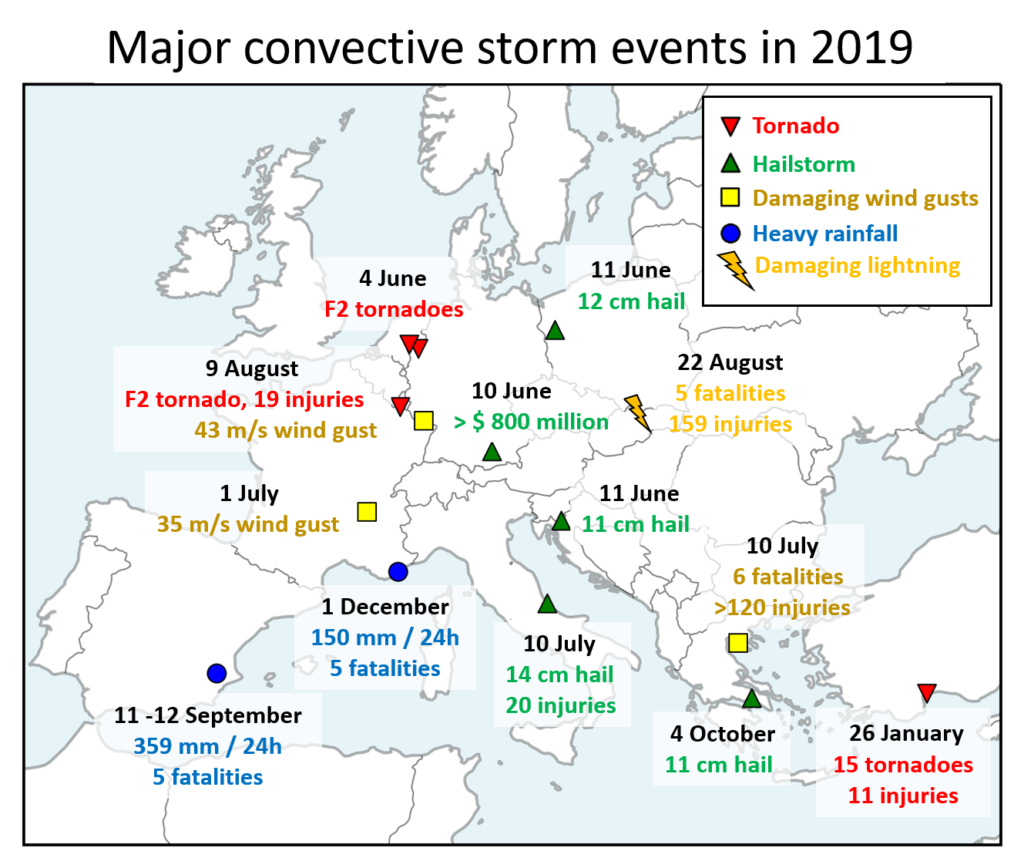
Below, you can find a list of 10 major severe convective storm events across Europe in 2019. Please note that this overview was selected subjectively by the ESSL staff and is not an exhaustive list of all major severe weather events that occurred in Europe in 2019.
An overview of major convective storm events across Europe in 2019.
26 January: Tornado outbreak over Turkey
The year started with an active severe weather period over the southeastern Mediterranean. On 26 January 2019, a local outbreak of tornadoes occurred over southern Turkey. 15 tornadoes were reported in total, two of which were rated F2. One of the strong tornadoes struck Antalya airport around 8 UTC, overturning a bus with passengers that resulted in 11 injuries. Numerous videos of this event appeared online. Besides tornadoes, storms also produced hail up to 4 cm in diameter over the land, damaging crops and cars.
4 June: Convective windstorm and tornadoes over western Germany and the Benelux
On 4 June, first thunderstorms formed over northern France in the late afternoon and quickly moved northwest, forming a large convective system. A swath of severe wind gusts was reported over Benelux with the highest measured gust of 30 m/s. In addition, several tornadoes occurred including two strong, F2 tornadoes: one in the Netherlands and one in western Germany.
10 to 11 June: Damaging hailstorms
10 June marked the beginning of an active period of severe weather over many parts of Europe. The most notable event on 10 June was a hailstorm that struck parts of Munich in the afternoon hours. Wind-driven of hail up to 6 cm in diameter, caused extensive damage to hundreds of cars and roofs. This event is set to be the most costly thunderstorm-related loss in 2019, with estimated losses of $ 800 million.
One day later, severe weather activity continued, and while no major economic losses were reported like the day before, the storms produced even bigger hail. Giant hail was reported from two locations: From the border of Slovenia and Croatia (up to 11 cm in diameter) and across western Poland (up to 12 cm in diameter). For Poland, this marked the largest documented hailstone.
1 July: Widespread severe weather over Europe
372 severe weather reports were collected in a belt from eastern France through Switzerland, northern Italy, southern Germany, the Czech Republic and Poland into Ukraine, making this day perhaps the most widespread severe weather outbreak of 2019 over Europe. Severe storms produced numerous reports of large hail, up to 7 cm in diameter and severe wind gusts. Such large hail was reported both in France and the Czech Republic. The strongest wind gust speed was measured to be 35 m/s in eastern France. Five people were injured by gusts in France and six in Italy, where the severe wind also caused one fatality.
10 July: Damaging wind gusts and giant hail over Italy and Greece
This was the last of a multi-day outbreak of severe storms over Italy and parts of the Balkans (more information on the whole outbreak can be found in a previously published blog post). On this day, severe thunderstorms had already formed over Italy during the morning with two tornado and several severe wind gusts reports. Shortly after 10 UTC, giant hail, up to 14 cm in diameter, was observed over the town of Pescara in the region Abruzzo, Italy. The hail that was combined with severe wind gusts injured 20 people. Further hail and severe wind gusts were reported across Italy later in the day.
Injuries were reported also with storms that impacted Greece during the afternoon. However, the most severe event unfolded in the evening around 19 UTC, when a storm system that had travelled hundreds of kilometres from Italy, rapidly strengthened as it crossed the Aegean Sea and hit the Halkidiki peninsula. There, 6 people died and more than 120 were injured due to the severe wind gusts. Many of the injuries resulted from loose outdoor furniture being flung into groups of tourists seeking shelter.
9 August: Severe wind gusts and tornadoes over western Europe
Severe storms occurred in a belt from southern France to the northern Netherlands. Severe weather began in the afternoon after 14:00 UTC with severe wind gusts and large hail over northern France. The most severe period occurred between 15 and 16:30 UTC with isolated supercells producing swaths of wind damage, including an F2 tornado that crossed from France into Luxembourg and caused 19 injuries in the town of Pétange, Luxembourg. Over eastern France, two weather stations clocked the wind gust measurements of 35.8 and 42.7 m/s. Later on, two F1 tornadoes were reported from the Netherlands between 19 and 20 UTC. One of them occurred directly in the centre of Amsterdam.
22 August 2019: Deadly lightning strikes in Poland and Slovakia
Weak thunderstorms formed over central Slovakia during the morning hours and moved towards the High Tatras mountains on the border between Slovakia and Poland. Hundreds of hikers were caught unprepared by the storm, resulting in a total of 5 fatalities and 159 injuries. The worst lightning strike was reported from Mt. Giewont in southern Poland with 4 fatalities and 156 injuries. People were knocked down from the mountain or received burns as they held on the steel cable supporting them on the steep ascent to the mountain. Rescue efforts continued till the late night. 1 person died and 3 were injured on the Slovakian side of the Tatras. The Mt. Giewont lightning strike set the record for the highest number of directly-caused lightning injuries in the ESWD.
11 – 12 September 2019: Flash floods over Spain
Within an easterly onshore flow bringing moisture rapidly inland, a quasi-stationary convective line formed over València in the late-night hours of 11 September 2019. After hours of extremely heavy rainfall, flash flooding followed in the morning of 12 September. By 03 UTC on 12 September, 359 mm of rain fell at the Benniarés station with a maximum 6 hourly sum of 191 mm. Station Ontinyent reported 296 mm of rain by 05 UTC, with 242 mm falling since midnight. 5 people perished during the flash floods, which brought widespread disruption to the region and left several settlements completely flooded. Besides heavy rain, an F1 tornado was reported shortly after midnight on 12 September.
4 October 2019: Giant hail over Greece
While large hail is not unheard of during the autumn over the Mediterranean, flash floods are usually the dominating risk of severe storms during that time of the year. However, on 4 October, a supercell that tracked over the Attica region, Greece, produced an impressive swath of large hail. Giant hail up to 11 cm in diameter was reported from 3 different villages. Of course, cars, roofs and windows were badly damaged by this storm.
1 December 2019: Flash floods over southern France
December did not start well for some in southern France. After high amounts of rainfall in the past period, another round of heavy rainfall led to flash floods that severely impacted the Provence region. Weather stations reported 130 – 150 mm of rainfall falling during the day. While such amounts are not too high for the given region, previous rainfall exacerbated the situation. The flash flooding resulted in 5 fatalities and many people had to be evacuated from their homes.