10th edition of the ESSL Testbed is upon us and will be held in four weeks: 14–18 June, 21–25 June, 5–9 July and 12–16 July. The second and third weeks are for invited experts, or participants who have already been to the Testbed before or other courses. Like last year, the Testbed will be held online. 44 participants have registered, 12 people for the regular and 10 for the expert weeks.
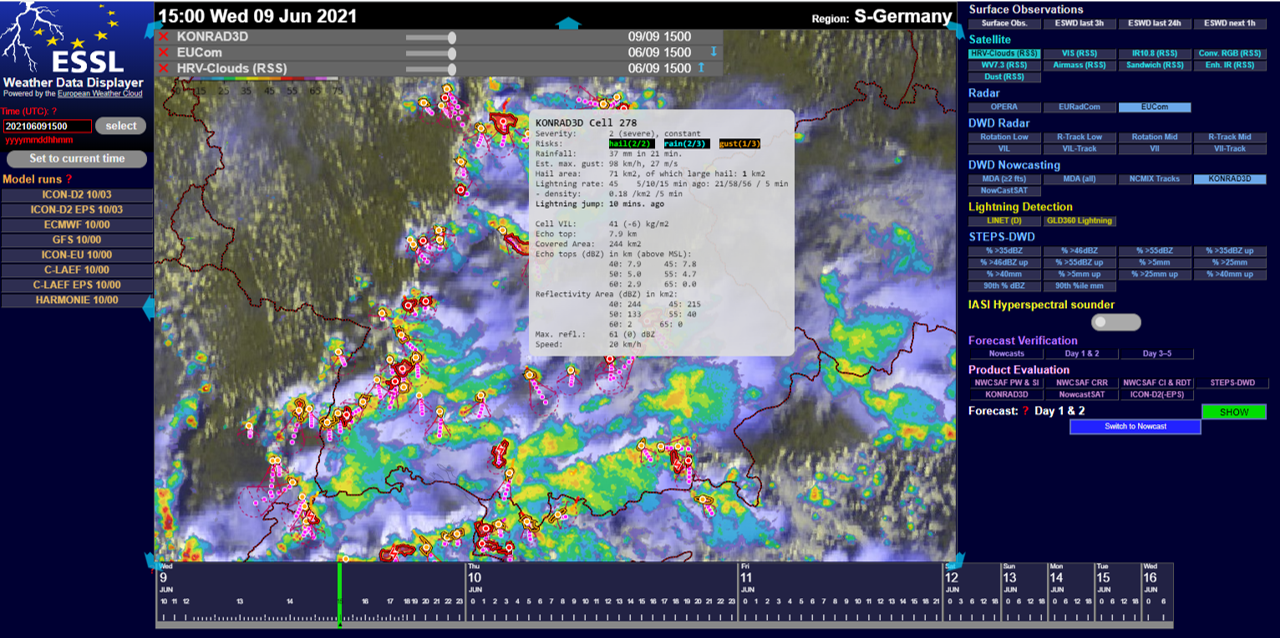
Compared to 2020, there are a few new aspects. First, we have improved our WeatherData Displayer, which has a new, darker layout, and now allows a smoother switching between different regions. Moreover, a transparency option for data layers has been added. There is also more NWP data in the displayer compared to last year, including ensemble output from ICON-D2 (DWD) and C-LAEF (ZAMG). The third convection allowing model is Harmonie (KNMI). A large part of the data processing is now done in the European Weather Cloud, with thanks to ECMWF.
Besides daily forecasts of convective storms, we are going to evaluate new tools developed for forecasting and nowcasting of convective storms. This year we will concentrate on:
Extreme Forecast Index and Shift of Tails for CAPE and CAPE-shear from ECMWF
C-LAEF ensemble prediction system from ZAMG
ICON-D2 ensemble prediction system from DWD
Modified Lightning Potential Index from DWD
KONRAD3D cell-tracking nowcasting tool from DWD
STEPS-DWD radar nowcasting tool from DWD
NowcastSAT satellite nowcasting tool from DWD
We are looking forward to all the participants and interesting discussions on these new products and the hopefully interesting weather situations!
We welcome external persons to join the daily Testbed weather briefings from Tuesday through Friday during Testbed weeks starting at 11:00 CEST (0900 UTC) until approximately 12:30 CEST (1030 UTC). To join, visit this link: https://bluejeans.com/720241930
We will post links to the recordings of the webinars here as they become available (this also depends whether our speakers agree to having their talk recorded)
To connect to the webinars, just follow the link: https://bluejeans.com/2536484999 and Bluejeans will guide through you through the rest! Make sure to reserve 5 – 10 minutes before the start of the webinar to allow your system to set up the Bluejeans and connect to the webinar.
The most important rule is to make sure your microphone is muted during the presentation! This will be done by default upon your arrival to the webinar, but please make sure this will be the case also individually. Depending on the number of participants, discussion will be either done throught the chat or more interactively.
*** GENERAL INFORMATION concerning the webinars ***
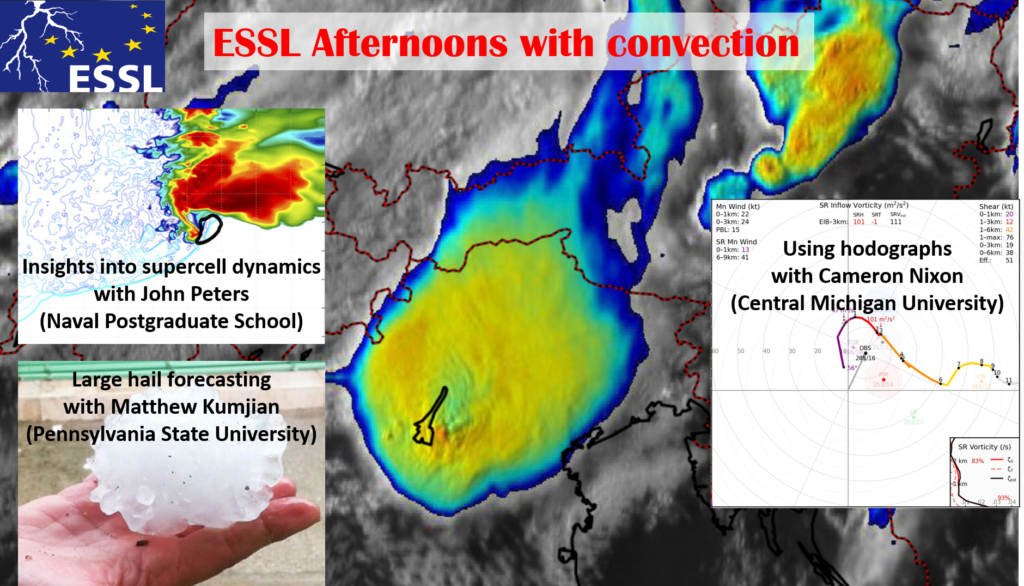
Last year we brought you a series of 3 “refreshers” to get ready for convective season. While the convective season picks up over Europe, this year we are organizing a series of 3 webinars called “Afternoons with convection” with severe weather experts to help you expand your horizons in convection forecasting!
The webinars
will take place on the Wednesdays 2, 9 and 30 June and will start at 13 UTC
(15:00 CEST). Each webinar consists of a lecture by a storm researcher followed
by a discussion and concludes with a discussion of the current weather
situation by Tomas Púčik and Christoph Gatzen (ESSL / ESTOFEX). The webinars end
at 15 UTC.
You do not need to register for the webinars! On Mondays, two days before each webinar, we will post a link on ESSL’s Twitter (@essl_ecss) and Facebook channels and the webpage (essl.org) with instructions how to connect. As last year, we will use the BlueJeans videoconferencing system.
We are
happy that the following expert researchers have offered to give a talk on
their recent work in the Afternoons with Convection series:
2 June
2021, Matthew Kumjian (The Pennsylvania State University)
Forecasting and nowcasting large hail.
Large hail
is the most costly thunderstorm-related threat and each year multiple events
with hail-related injuries occur across Europe. Matt will discuss new findings
of his research group concerning the physics of large hail formation, such as how
the pre-convective environment influences the growth of large hailstones and
how to recognize truly damaging hailstorms.
9 June
2021, John Peters (Naval Postgraduate School)
New insights on dynamics of supercells
Understanding
why storms behave in a certain way is very important for all forecasters. John
will talk about his novel research results concerning various aspects of storm
dynamics, including how shear modulates the width and strength of convective
updrafts, in what ways updrafts of supercells are special, and what role entrainment
plays in the evolution of updrafts.
30 June 2021, Cameron Nixon (Central Michigan University) Using hodographs to their fullest potential.
Long? Short? Curved?
Straight? Hodographs offer a holistic approach to study vertical wind shear in
the context of convective storm dynamics. Cameron will talk about how hodographs
can predict supercell behavior, hazards, and even visual appearance, and how
learning patterns rather than bulk shear or SRH will improve our forecasts in
the future.
A two-part study on the climatology of severe convective storms over Europe and the U.S. was recently published in the Journal of Climate. The study was led by Dr. Mateusz Taszarek of the National Severe Storms Laboratory (Norman, OK, USA) and Adam Mickiewicz University (Poznán, Poland) with contributions from ESSL among others. The study used lightning detection data, European Severe Weather Database reports, Storm Data reports and the ERA-5 reanalysis to answer the research questions.
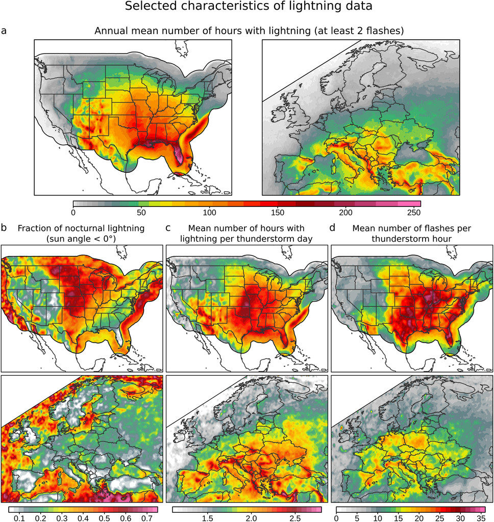
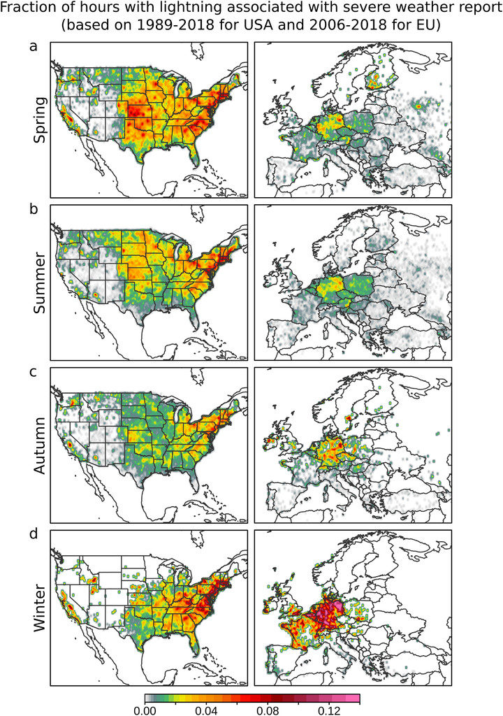
The first part, “Severe Convective Storms across Europe and the United States. Part I: Climatology of Lightning, Large Hail, Severe Wind, and Tornadoes“, deals with the climatology of lightning and severe weather reports. In general, there is more lightning over the U.S. and thunderstorms tend to last longer and produce more strikes than over Europe. Over continental Europe, most of the thunderstorms occur during the day, but the opposite is true for the continental U.S., where more than 50% of lightning occurs at night. A higher frequency of thunderstorms at night is observed over the seas, particularly over the southeastern Mediterranean.
(a) Annual mean number of hours with lightning, (b) fraction of nocturnal lightning, (c) mean number of hours with lightning per thunderstorm day, and (d) mean number of flashes per thunderstorm hour over the United States (1989–2018) and Europe (2006–18). Data are presented in 0.25° boxes with a 0.75° × 0.75° spatial smoother. Nocturnal lightning is defined when a sun angle for a specific grid and date is below 0°. Copyright of American Meteorological Society, CC-BY License.
Over the U.S., the fraction of lightning hours associated with severe weather reports is higher than over Europe with the exception of winter, when a seasonal maximum is observed over both areas. One can also clearly see stronger reporting inhomogeneity across European countries in contrast to the more homogeneous Storm Data that cover the U.S.. Compared to Europe, extreme events are considerably more frequent over the United States, with a maximum activity over the Great Plains. However, the threat over Europe should not be underestimated, as severe weather outbreaks with damaging winds, very large hail, and significant tornadoes occasionally occur over densely populated areas
Fraction of hours with lightning associated with tornadoes, large hail, and severe wind over the seasons in the United States (1989–2018) and Europe (2006–18). Data are presented in 0.25° boxes with a 0.75° × 0.75° spatial smoother. Copyright of American Meteorological Society, CC-BY License.
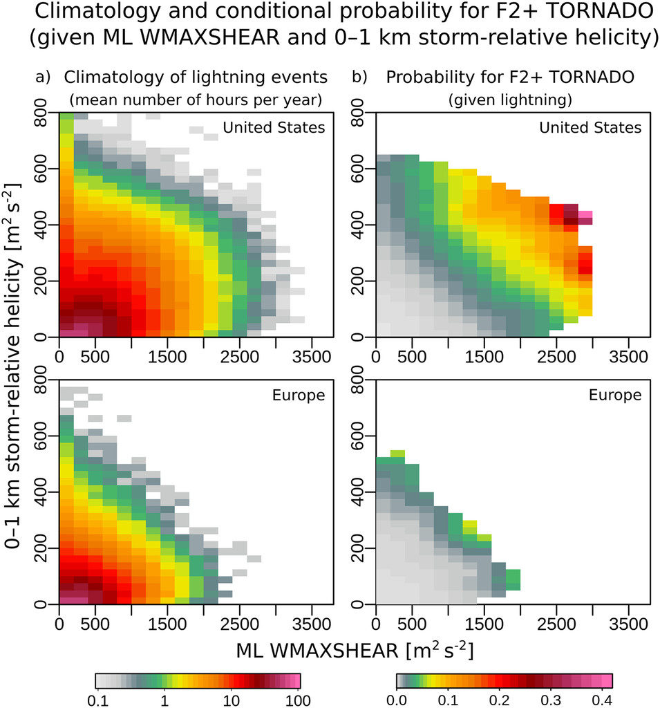
The second part, “Severe Convective Storms across Europe and the United States. Part II: ERA5 Environments Associated with Lightning, Large Hail, Severe Wind, and Tornadoes“, deals with the environments of severe convective storms and their hazards derived from the ERA-5 reanalysis. The U.S. experiences more extreme severe convective storm environments than Europe when considering how often high CAPE, strong vertical wind shear and high Storm Relative Helicity (SRH) occur. This explains why tornadoes are rarer over Europe than over the U.S. On the other hand, 0-3km CAPE is higher and low-level lapse rates are steeper over Europe.
(a) Scaled mean number of hours per year with lightning and (b) conditional probability as for significant tornados (F2+) given specific ML WMAXSHEAR (product of square root of 2* MLCAPE and 0-6 km bulk shear) and 0–1-km storm-relative helicity parameter space. Copyright of American Meteorological Society, CC-BY License.
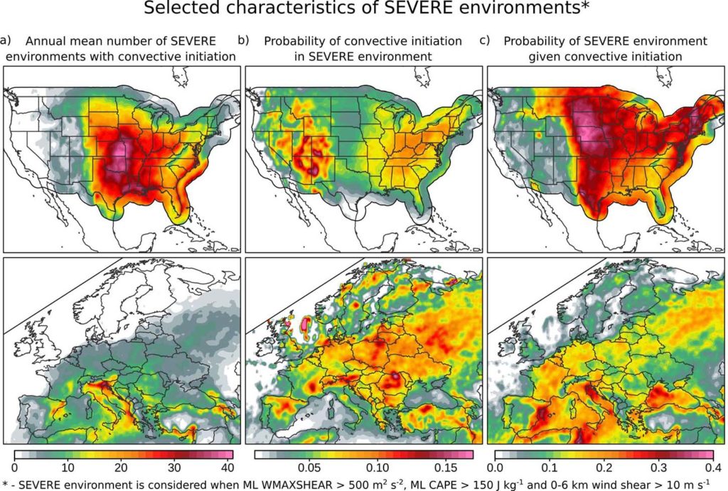
While environments conducive to severe convection (characterized by the simultaneous occurrence of CAPE and shear) occur more frequently over the U.S., European severe storm environments more frequently result in storms. 30 – 40% of the thunderstorms over the midwest of the U.S. form in conditions conducive to severe weather, in contrast to 10 – 25% of thunderstorms over central and western Europe. Over Europe, the highest fraction of thunderstorms forming in severe environments is found over the Balearic Sea and the northern Adriatic Sea.
(a) Annual mean number of situations (hours) with severe environments and lightning detection (at least 2 flashes), (b) probability of convective initiation in severe environment (fraction of severe environments associated with lightning), and (c) probability that a developing thunderstorm will be be associated with severe environment (fraction of lightning events associated with severe environments). Copyright of American Meteorological Society, CC-BY License.
Additionally, an animation of the annual cycle of lightning activity, MLCAPE and 0-6 km vertical wind shear over both areas can be seen below. Over Europe, one can see a shift of thunderstorm activity from land to sea as the year progresses from spring and summer to autumn. In both areas, the seasonal increase in CAPE is accompanied by a decrease in shear and vice versa. The U.S. Midwest sees a pronounced combined occurrence of high CAPE and strong shear in the spring, while it occurs across western Mediterranean in autumn.
Taszarek, M., Allen, J. T., Groenemeijer, P., Edwards, R., Brooks, H. E., Chmielewski, V., & Enno, S. (2020). Severe Convective Storms across Europe and the United States. Part I: Climatology of Lightning, Large Hail, Severe Wind, and Tornadoes, Journal of Climate, 33(23), 10239-10261. Retrieved Dec 9, 2020, from https://journals.ametsoc.org/view/journals/clim/33/23/jcliD200345.xml
Taszarek, M., Allen, J. T., Púčik, T., Hoogewind, K. A., & Brooks, H. E. (2020). Severe Convective Storms across Europe and the United States. Part II: ERA5 Environments Associated with Lightning, Large Hail, Severe Wind, and Tornadoes, Journal of Climate, 33(23), 10263-10286. Retrieved Dec 9, 2020, from https://journals.ametsoc.org/view/journals/clim/33/23/jcliD200346.xml
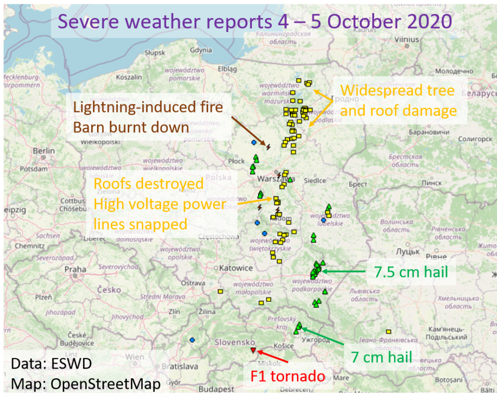
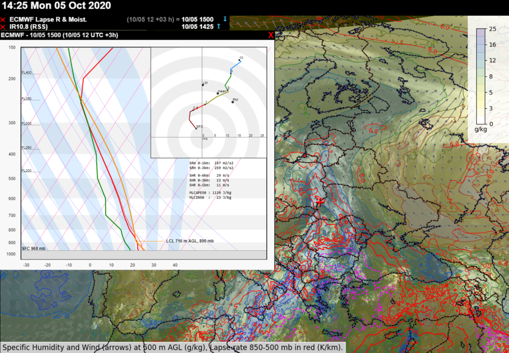
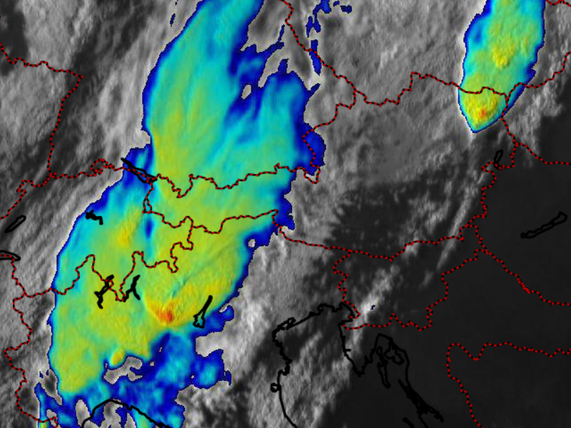
Severe weather outbreaks in autumn are quite typical over the Mediterranean but rarer over continental parts of Europe. On 4 and 5 October, an unusual synoptic-scale situation led to an outbreak of severe thunderstorms over eastern Slovakia and Poland.
During these two days, a total of 36 large hail reports (with 5 reports of hail exceeding 5 cm in diameter), 71 reports of severe wind gusts (with several instances of F1 damage), 4 reports of damaging lightning and an F1 tornado report were entered into the European Severe Weather Database (eswd.eu). The map below gives an overview of the impacts. While severe convective wind gusts are not uncommon with deep low pressure systems over this part of Europe, hail reaching 7 cm or more in diameter is exceptional for this time of year.
Severe weather reports on 4 and 5 October 2020. Data source: eswd.eu
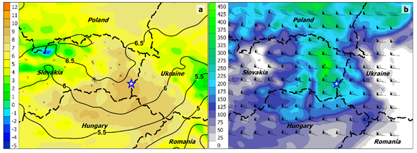
The outbreak was caused by severe thunderstorms developing in a very warm and moist airmass that had been advected northward from the southern Mediterranean Sea (Fig 2). Mixing ratios of 10 – 12 g/kg allowed 500 – 1500 J/kg of MLCAPE to build over the area. Combined with strong vertical wind shear (exceeding 20 m/s in the 0-3 km layer), thunderstorms quickly turned severe as they organized into supercells and bow-echoes.
IR satellite imagery combined with an ECMWF forecast of specific humidity at 500 m AGL (g/kg, filled contours) and lapse rates between 850 and 500 hPa (K/km, red to purple contours). Forecast sounding and hodograph are representative of the location indicated by red cross.
More information concerning the F1 tornado over southern Slovakia can be found here. ESSL would like to thank Skywarn Polska and the Slovak Hydro-Meteorological Institute for providing severe weather reports!
In November, ESSL and EUMETSAT are introducing a new course called “Optimal use of satellite data in forecasting severe convection“. The course will concentrate on how to effectively use satellite data in nowcasting severe convection and will provide both the theoretical background on the basic dynamics of severe convective storms, as well as a satellite perspective on each discussed topic. In the afternoon, we will apply the gained knowledge in a forecasting / nowcasting exercise using the selected case studies. Click on the link above to find out more.
The course will last 4 days between 16 and 19 November and will be held online, so there is no need to travel anywhere. The early fee period has been extended till 30 September. So, if you are interested, please do not wait too long with registering here.
Severe storms impacting northern Italy and Vienna on 12 August 2019 with pronounced overshooting tops and above-anvil cirrus plumes apparent in the satellite data.
Tornado forecasting can be very challenging, especially in low CAPE – high shear environments and when lower tropospheric shear is only locally enhanced. Such was the case of an F1 tornado that hit the village of Lekárovce in eastern Slovakia on 3 October 2018. This tornado is the main subject of a paper “A Challenging Tornado Forecast in Slovakia” that has been recently published in the journal Atmosphere. The study was led by Miroslav Šinger from Comenius University and Slovak Hydrometeorological Institute in Bratislava and co-authored by Tomáš Púčik from ESSL.
Roof damaged by the tornado and a toppled concrete cross. Author: Martin Žec.
Authors of the study attempted to reconstruct the
environment leading up to the tornado based on the observational datasets and
compared it with the model data that was available to forecasters in the
morning hours before the tornado. One of the main aims of the paper was to show
whether observational data or the higher resolution run of the local model
would improve the ability to identify conditions favourable for tornadogenesis.
Tornado occurred in the early afternoon hours underneath strong west-northwesterly mid to upper tropospheric flow at the flank of a deep low-pressure system. Enhanced lower tropospheric moisture combined with mid-tropospheric lapse rates of 6.5 K/km allowed for a build-up of marginal CAPE reaching 200 – 300 J/kg.
Model forecast of 3 October 2018 12:00 UTC (a) Average lapse rate in 900–600 hPa layer (black isolines) (°C·km−1) and dew-point temperature at 2 m (color scale) (°C); (b) surface-based convective available potential energy (CAPE; color scale) (J·kg−1) and deep-layer shear (wind barbs: full barb, 5 m·s−1; half barb, 2.5 m·s−1; flag, 25 m·s−1). Country names shown in italics; tornado location highlighted by blue star.
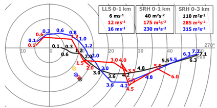
But while the deep-layer shear was very strong, models predicted a decrease in 0-1 km shear between morning and early afternoon hours with surface wind veering from East to West. However, easterly wind direction persisted over eastern Slovakia for much longer, yielding strong lower-tropospheric shear as the storms developed in the afternoon. Study shows that using both observational datasets and the higher resolution version of the local area model would alert the forecaster to the presence of strong lower tropospheric shear over the area of interest.
Hodographs representing the environment before tornadogenesis based on observational datasets (red), model forecast available to the forecasters (black), and the experimental higher resolution run (blue). Crossed circles represent the storm-motion based on Bunker`s method, orange represents the real vector derived from the radar data. Values of low-level wind shear (LLS) and storm relative helicity (SRH) in 0–1 and 0–3 km layers for individual hodographs are shown in top-right corner.
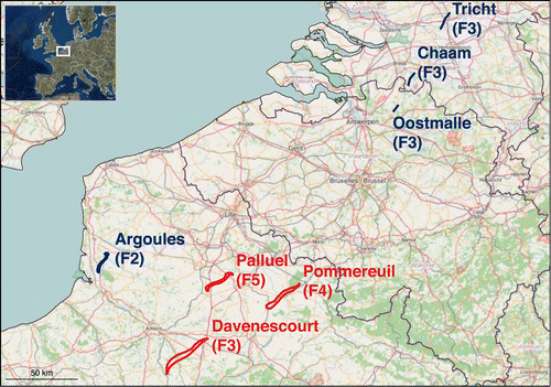
The tornado outbreak of 24–25 June 1967 remains the second deadliest tornado outbreak over Europe since 1950 after the tornado outbreak of 9 June 1984 over Russia. Over the course of two days, one F2 tornado, four F3 tornadoes, one F4 tornado, and one F5 tornado struck France, Belgium and Holland (Fig. 1), resulting in 15 fatalities and 234 injuries.
Figure 1. Tornado tracks from 24 (red) and 25 (blue colour) June 1967.
In a study from 2018, a team led by Bogdan Antonescu looked at the details of the outbreak and at what would be the consequences if a similar tornado outbreak will occur 50 years later (i.e., 2017). This was done by transposing the seven tornado tracks from the June 1967 outbreak over the modern landscape. Due to urban growth, it is possible that tornadoes could cause even more impact than in 1967. Based on the statistics of fatality and injury rates associated with European extracted from the European Severe Weather Database, a similar tornado outbreak with the one that occurred in 1967, would result in 55–2580 injuries, and 17–172 fatalities. In the worst-case scenario, with tornado tracks moving over highly populated areas over the region, up to 146 222 buildings could be impacted with 2550–25 440 injuries and 170–1696 fatalities. This study clearly shows how impactful such a tornado outbreak could be to society.
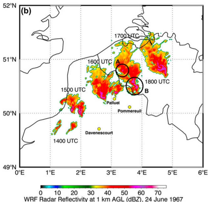
A follow-up study that has just been published in Weather and Forecasting (link) hindcasts the tornado outbreak using an WRF-ARW simulation, with initial and boundary conditions provided by ERA-40 reanalysis and the highest-resolution domain with 800-m grid spacing. The model simulated an environment conducive for tornadic supercells with CAPE exceeding 2000 J/kg, 0–6 km bulk shear between 20–25 m/s and Storm Relative Helicity reaching 300 m²/s² in the 0–3-km layer. The model was also able to explicitly simulate a number of supercells over the region of interest (Fig. 2).
Figure 2. Timestamps of radar reflectivity echo at 14, 15, 16 and 17 UTC on 24 June 1967.
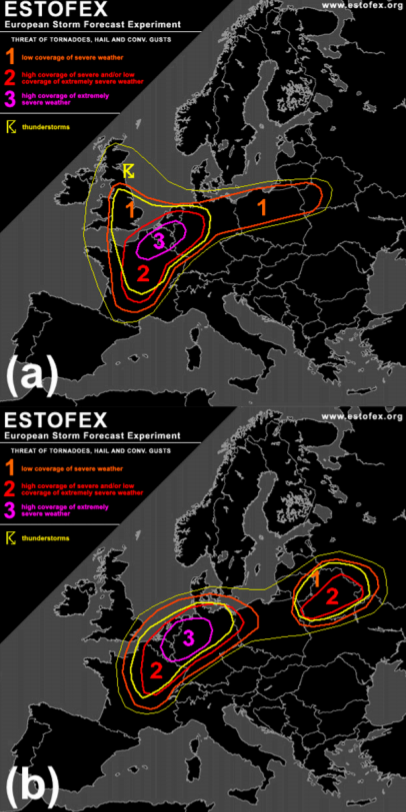
One of the questions posed by the article is how would a forecast of such an event look like today? To do this, an ESTOFEX forecaster was presented with a set of forecast maps for both days (without knowing the dates) and asked to provide Day-1 outlooks. The forecaster issued Level 3 (the highest risk of severe weather) for both days, on (Fig. 3). This paper demonstrates that, with our understanding of severe convective storms and state-of-the-art numerical modelling, a forecast of a tornado outbreak over Europe is possible. Given how much societal impact significant tornadoes can cause, addressing their threat should be part of any convective storm forecast.
Figure 3. ESTOFEX hindcast outlooks for a) 24 June 1967 and b) 25 June 1967.
Full versions of both studies can be freely accessed here:
In the beginning of January, we published a series of posts on social media about severe weather in 2019. This blog puts together this information and graphics, and provides an overview of the most prominent severe weather events of the year.
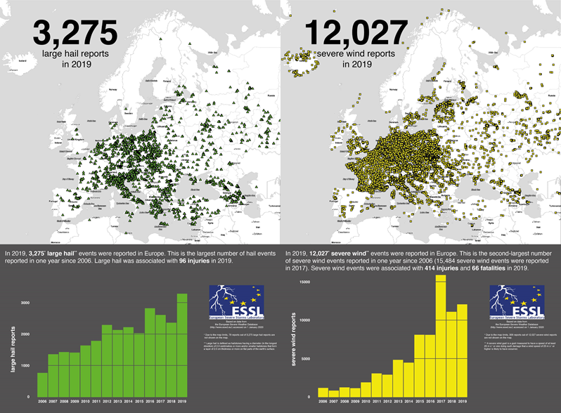
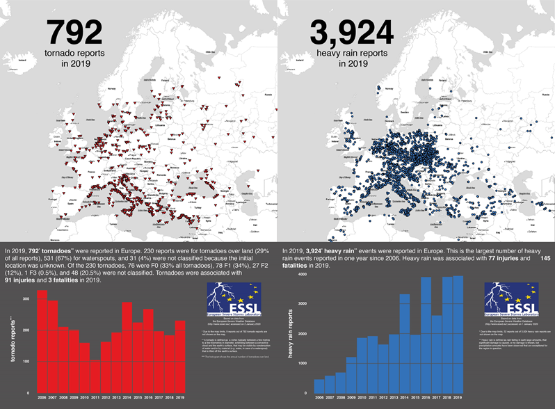
2019 was a comparatively active severe weather year. ESSL received 3275 reports of large hail as well as 12 027 severe wind gust reports, 792 reports of tornadoes and 3924 of heavy rain. This year has the highest number of large hail and heavy rain reports since the ESWD was established in 2006, and it was exceptional especially regarding the large hail. For example, more than 96 hail-related injuries were reported with 15 hail events, while hail injuries were reported only 96 times in the whole history of the database. In addition, 14 events included giant hail, reaching or exceeding the size of 10 cm. Further fatalities and injuries were reported with severe wind gusts: 66 and 414, respectively.
An overview of large hail and severe wind gust reports across Europe in 2019.
Tornadoes caused 3 fatalities and 97 injuries and were reported mostly near the coasts of the Mediterranean Sea. 531 out of 792 tornadoes occurred exclusively over water, and can thus be called waterspouts. There were 28 strong tornadoes during the year, of which 27 were rated F2 and 1 F3. Heavy rain caused 145 fatalities and 77 injuries. Most of the reports came from Central Europe and from Italy.
An overview of tornado and heavy rain reports across Europe in 2019.
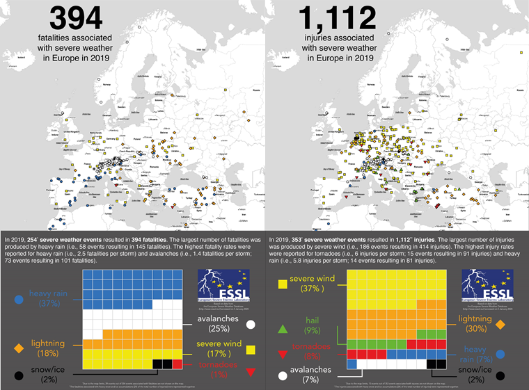
In total, severe weather killed 394 people and 1112 people were injured during 2019. Most of the fatalities were attributable to heavy rainfall, followed by avalanches and lightning. Most of the injuries were caused by severe wind gusts, followed by lightning and hail. While heavy rain comprised 37% of all fatalities, it contributed to only 7% of injuries. Tornadoes caused about 1% of fatalities and 8% of injuries. This shows how differently the impact of severe weather phenomena can be.
Severe weather related fatalites and injures across Europe in 2019.
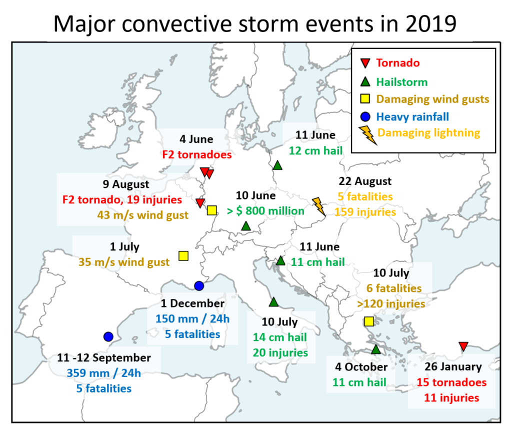
Below, you can find a list of 10 major severe convective storm events across Europe in 2019. Please note that this overview was selected subjectively by the ESSL staff and is not an exhaustive list of all major severe weather events that occurred in Europe in 2019.
An overview of major convective storm events across Europe in 2019.
26 January: Tornado outbreak over Turkey
The year started with an active severe weather period over the southeastern Mediterranean. On 26 January 2019, a local outbreak of tornadoes occurred over southern Turkey. 15 tornadoes were reported in total, two of which were rated F2. One of the strong tornadoes struck Antalya airport around 8 UTC, overturning a bus with passengers that resulted in 11 injuries. Numerous videos of this event appeared online. Besides tornadoes, storms also produced hail up to 4 cm in diameter over the land, damaging crops and cars.
4 June: Convective windstorm and tornadoes over western Germany and the Benelux
On 4 June, first thunderstorms formed over northern France in the late afternoon and quickly moved northwest, forming a large convective system. A swath of severe wind gusts was reported over Benelux with the highest measured gust of 30 m/s. In addition, several tornadoes occurred including two strong, F2 tornadoes: one in the Netherlands and one in western Germany.
10 to 11 June: Damaging hailstorms
10 June marked the beginning of an active period of severe weather over many parts of Europe. The most notable event on 10 June was a hailstorm that struck parts of Munich in the afternoon hours. Wind-driven of hail up to 6 cm in diameter, caused extensive damage to hundreds of cars and roofs. This event is set to be the most costly thunderstorm-related loss in 2019, with estimated losses of $ 800 million.
One day later, severe weather activity continued, and while no major economic losses were reported like the day before, the storms produced even bigger hail. Giant hail was reported from two locations: From the border of Slovenia and Croatia (up to 11 cm in diameter) and across western Poland (up to 12 cm in diameter). For Poland, this marked the largest documented hailstone.
1 July: Widespread severe weather over Europe
372 severe weather reports were collected in a belt from eastern France through Switzerland, northern Italy, southern Germany, the Czech Republic and Poland into Ukraine, making this day perhaps the most widespread severe weather outbreak of 2019 over Europe. Severe storms produced numerous reports of large hail, up to 7 cm in diameter and severe wind gusts. Such large hail was reported both in France and the Czech Republic. The strongest wind gust speed was measured to be 35 m/s in eastern France. Five people were injured by gusts in France and six in Italy, where the severe wind also caused one fatality.
10 July: Damaging wind gusts and giant hail over Italy and Greece
This was the last of a multi-day outbreak of severe storms over Italy and parts of the Balkans (more information on the whole outbreak can be found in a previously published blog post). On this day, severe thunderstorms had already formed over Italy during the morning with two tornado and several severe wind gusts reports. Shortly after 10 UTC, giant hail, up to 14 cm in diameter, was observed over the town of Pescara in the region Abruzzo, Italy. The hail that was combined with severe wind gusts injured 20 people. Further hail and severe wind gusts were reported across Italy later in the day.
Injuries were reported also with storms that impacted Greece during the afternoon. However, the most severe event unfolded in the evening around 19 UTC, when a storm system that had travelled hundreds of kilometres from Italy, rapidly strengthened as it crossed the Aegean Sea and hit the Halkidiki peninsula. There, 6 people died and more than 120 were injured due to the severe wind gusts. Many of the injuries resulted from loose outdoor furniture being flung into groups of tourists seeking shelter.
9 August: Severe wind gusts and tornadoes over western Europe
Severe storms occurred in a belt from southern France to the northern Netherlands. Severe weather began in the afternoon after 14:00 UTC with severe wind gusts and large hail over northern France. The most severe period occurred between 15 and 16:30 UTC with isolated supercells producing swaths of wind damage, including an F2 tornado that crossed from France into Luxembourg and caused 19 injuries in the town of Pétange, Luxembourg. Over eastern France, two weather stations clocked the wind gust measurements of 35.8 and 42.7 m/s. Later on, two F1 tornadoes were reported from the Netherlands between 19 and 20 UTC. One of them occurred directly in the centre of Amsterdam.
22 August 2019: Deadly lightning strikes in Poland and Slovakia
Weak thunderstorms formed over central Slovakia during the morning hours and moved towards the High Tatras mountains on the border between Slovakia and Poland. Hundreds of hikers were caught unprepared by the storm, resulting in a total of 5 fatalities and 159 injuries. The worst lightning strike was reported from Mt. Giewont in southern Poland with 4 fatalities and 156 injuries. People were knocked down from the mountain or received burns as they held on the steel cable supporting them on the steep ascent to the mountain. Rescue efforts continued till the late night. 1 person died and 3 were injured on the Slovakian side of the Tatras. The Mt. Giewont lightning strike set the record for the highest number of directly-caused lightning injuries in the ESWD.
11 – 12 September 2019: Flash floods over Spain
Within an easterly onshore flow bringing moisture rapidly inland, a quasi-stationary convective line formed over València in the late-night hours of 11 September 2019. After hours of extremely heavy rainfall, flash flooding followed in the morning of 12 September. By 03 UTC on 12 September, 359 mm of rain fell at the Benniarés station with a maximum 6 hourly sum of 191 mm. Station Ontinyent reported 296 mm of rain by 05 UTC, with 242 mm falling since midnight. 5 people perished during the flash floods, which brought widespread disruption to the region and left several settlements completely flooded. Besides heavy rain, an F1 tornado was reported shortly after midnight on 12 September.
4 October 2019: Giant hail over Greece
While large hail is not unheard of during the autumn over the Mediterranean, flash floods are usually the dominating risk of severe storms during that time of the year. However, on 4 October, a supercell that tracked over the Attica region, Greece, produced an impressive swath of large hail. Giant hail up to 11 cm in diameter was reported from 3 different villages. Of course, cars, roofs and windows were badly damaged by this storm.
1 December 2019: Flash floods over southern France
December did not start well for some in southern France. After high amounts of rainfall in the past period, another round of heavy rainfall led to flash floods that severely impacted the Provence region. Weather stations reported 130 – 150 mm of rainfall falling during the day. While such amounts are not too high for the given region, previous rainfall exacerbated the situation. The flash flooding resulted in 5 fatalities and many people had to be evacuated from their homes.
A new study, resulting from cooperation of researches from ESSL and Munich-RE, called “Large hail incidence and its economic and societal impacts across Europe” has just been published in the Monthly Weather Review.
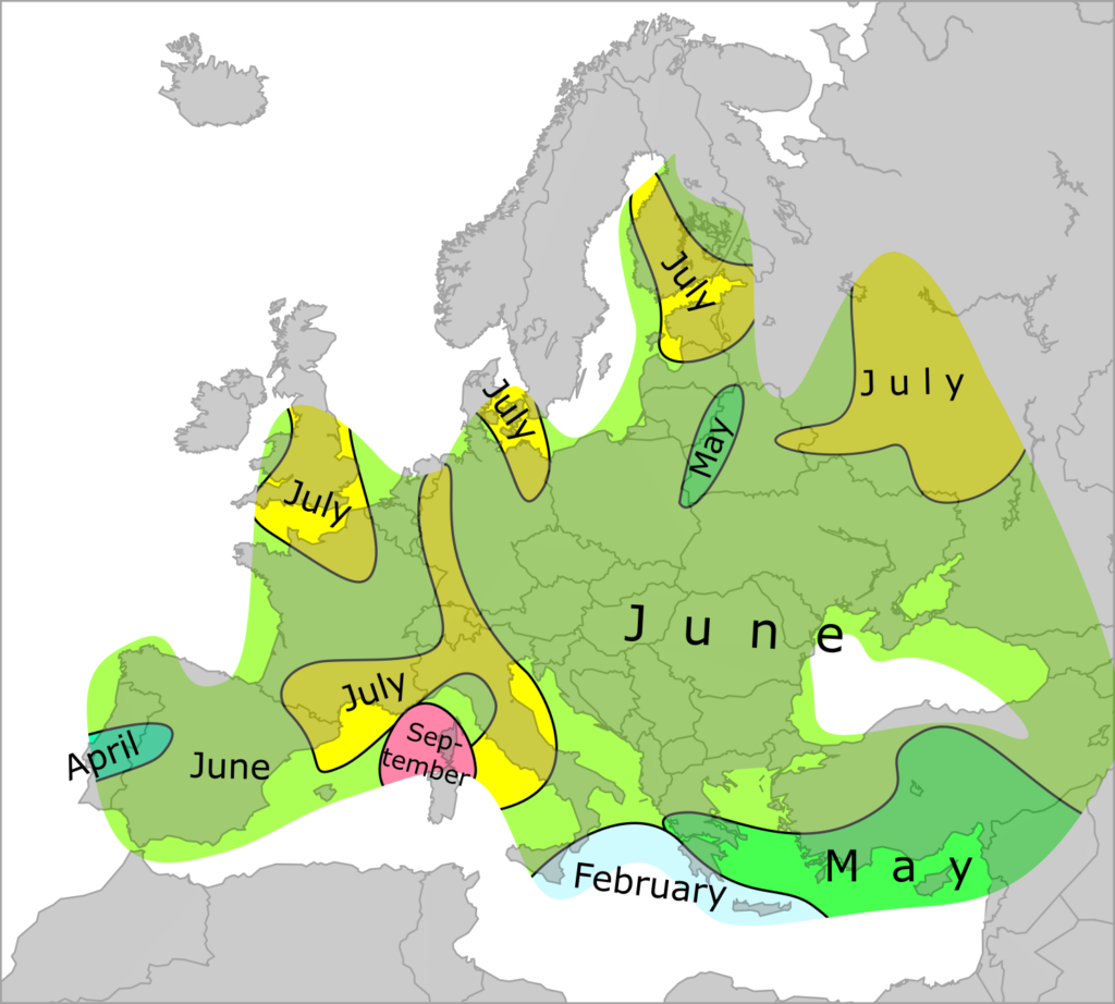
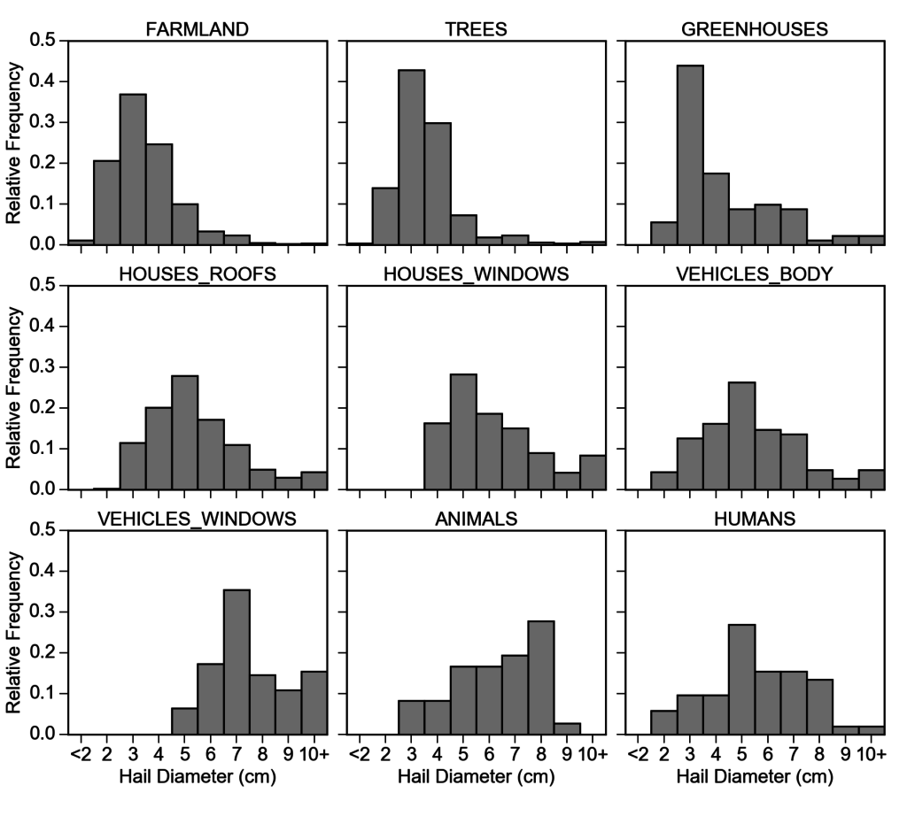
This study addresses the large hail incidence in Europe and its economic and societal impacts from multiple perspectives. Two main datasets used in the study were the European Severe Weather Database and the NatCatDATABASE of Munich-RE. While authors acknowledge that ESWD still does not allow for a homogeneous climatology of large hail across whole Europe, one can still learn many things from the data, such as the peak month of large hail occurrence in Europe (Fig. 1), hail size distribution, or how many injuries were reported with large hail.
Damage description that can be entered in the ESWD was used to investigate how the different types of hail damage depend on the reported hail sizes. It was found out that damage to trees, crops or greenhouses is typically reported with hail sizes of 2 – 4 cm in diameter, but damage to roofs, vehicles and windows usually occurs with hail size larger than 4 cm (Fig 2.). Furthermore, damage to vehicle windows was never reported with hail smaller than 5 cm in diameter.
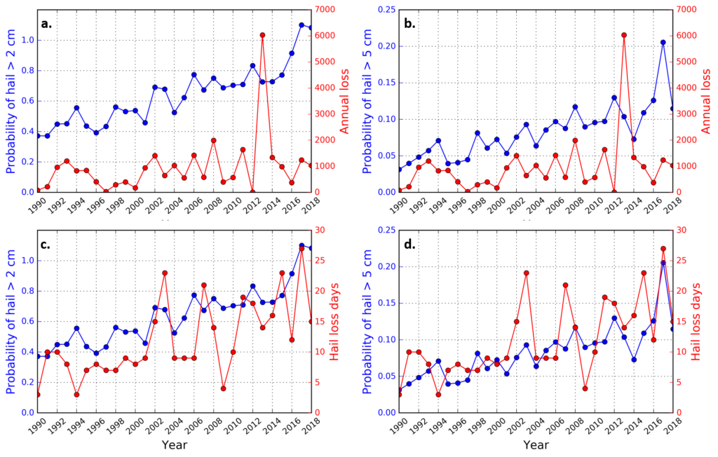
Authors also looked at how hail-related monetary losses have evolved since 1990 over Germany based on the data from NatCatDATABASE of Munich-RE. It was found out that while time serie of annual hail losses is dominated by outliers with very high losses (e.g. the event of 27 to 28 July 2013, which claimed over 4 billions of $ in total losses), the number of annual hail loss days shows a statistically significant rising trend (Fig. 3). Besides increasing vulnerability, the frequency of severe storm environments capable of producing large hail has increased as well, as demonstrated by ARCHaMo models Rädler et al. (2018) applied to the ERA-Interim data.
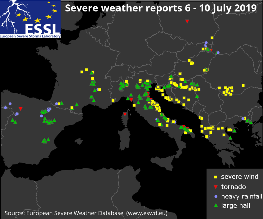
In the recent days, parts of western and southern Europe have experienced an extraordinary outbreak of severe weather. Between 6 and 10 July 2019, 480 reports were submitted to the European Severe Weather Database (www.eswd.eu). The severe weather included flash floods, large hail, tornadoes, and damaging wind gusts.
During this period, the largest reported hailstones fell on 10 July in Pescara, Italy, and were estimated at 14 cm in diameter. This almost ties the previous record hailstone size in the database, 15 cm, observed on 20 June 2016 in Timișoara, Romania.
The storms had large societal impacts with 10 fatalities (6 in Greece) and 90 injuries (48 in Greece alone, but some media mention that up to 100 people have been injured), mostly from damaging wind gusts and hail. Most fatalities and injuries were reported on 10 July in northern Greece, following a convective windstorm that hit Chalkidiki. The highest number of severe weather reports originated from Italy, where more than 150 reports were collected during the 5 subsequent days of this severe weather outbreak.
Severe weather reports from the European Severe Weather Database between 6 and 10 July 2019.
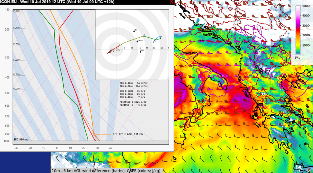
What caused such a long-lasting outbreak of severe convective storms that impacted areas like Northeastern Italy several times in a row? The reason was a stalling frontal zone over the Alpine range, which initiated storms in a very moist air-mass with high convective available potential energy (CAPE) that frequently exceeded 2000 J/kg. Such high CAPE values supported strongupdrafts in forming convective storms. At the same time, strong winds in the mid and upper troposphere (between 3 and 10 km above the surface) south of the front, created strong vertical wind shear. The wind shear helped the storms to organize into supercells (storms with rotating updrafts) or intense squall lines and bow-echoes, which are known for the strong winds they can produce. The figure below shows that, high CAPE (colours) and strong vertical wind shear (wind barbs) were collocated over southern Italy and Greece on 10 July. The outbreak only ended as the frontal zone finally moved southeast, followed by drier and cooler air in its wake.
00 UTC 10 July 2019 ICON forecast of 12 UTC CAPE (colors) and 0-6 km bulk vertical wind shear (barbs and contours). A forecast sounding and hodograph are shown, valid for the location of the red cross.
What happened on the individual days of the outbreak? On 6 July 2019 severe weather was reported from France and Italy. Over France, very large hail up to 8 cm in diameter and wind damage occurred. Over Italy, the regions of Friuli-Venezia Giulia, Veneto and Piemonte experienced very large hail. The area nea Vercelli was particularly hard hit with roofs completely destroyed by hail and cars heavily damaged with windows broken out. Severe wind gusts were reported from Switzerland.
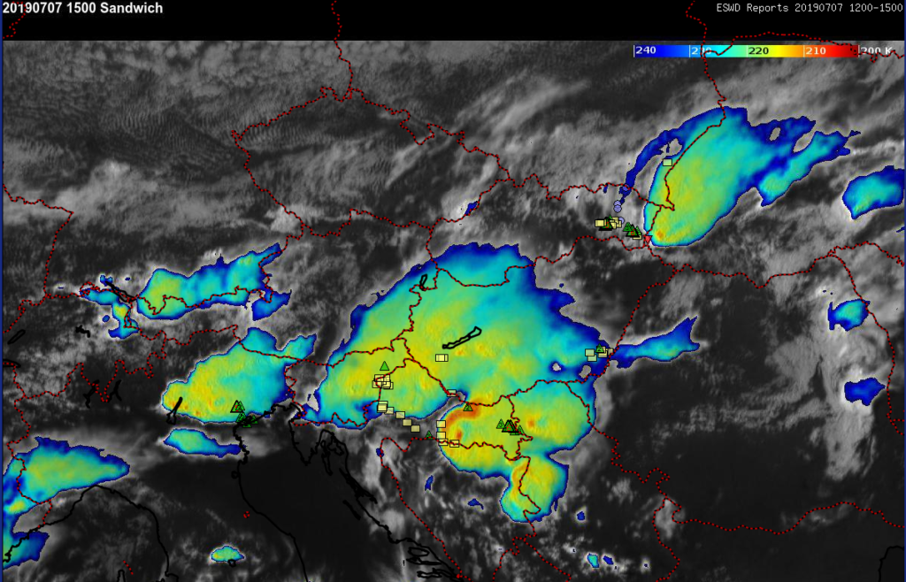
7 July 2019 featured the most extensive area of severe weather that occurred in two belts: from southeastern Slovakia to Ukraine and from northeastern Italy towards Romania. Very large hail, up to 7 cm across, was reported from Croatia and a swath of severe wind gusts extended along the Adriatic Sea coastline and from Serbia to Romania. A 32 m/s wind gust was measured in westernRomania in the evening hours and 30 m/s wind gust was measured in Zadar, Croatia overnight. Furthermore, a tornado was reported from Syurte, Ukraine, which occured with a long-lived supercell that also produced very large hail and downbursts over Slovakia.
7 July 2019 15 UTC Meteosat-10 visible and infrared – BT enhanced satellite imagery combination (sandwich) with ESWD reports from the previous 3 hours. Green triangles represent large hail (number inside indicates the diameter), yellow squares severe wind gusts and red triangles tornadoes. Data source: EUMETSAT, ESSL.
On 8 July 2019, severe thunderstorms again impacted northeastern Italy with very large hail. However, arguably the most severe weather happened in Spain, where severe flash floods killed a person in the town of Morriones. Besides flash flooding, very large hail up to 8 cm, a F1 tornado and severe wind gusts were reported from the northern part of the country.
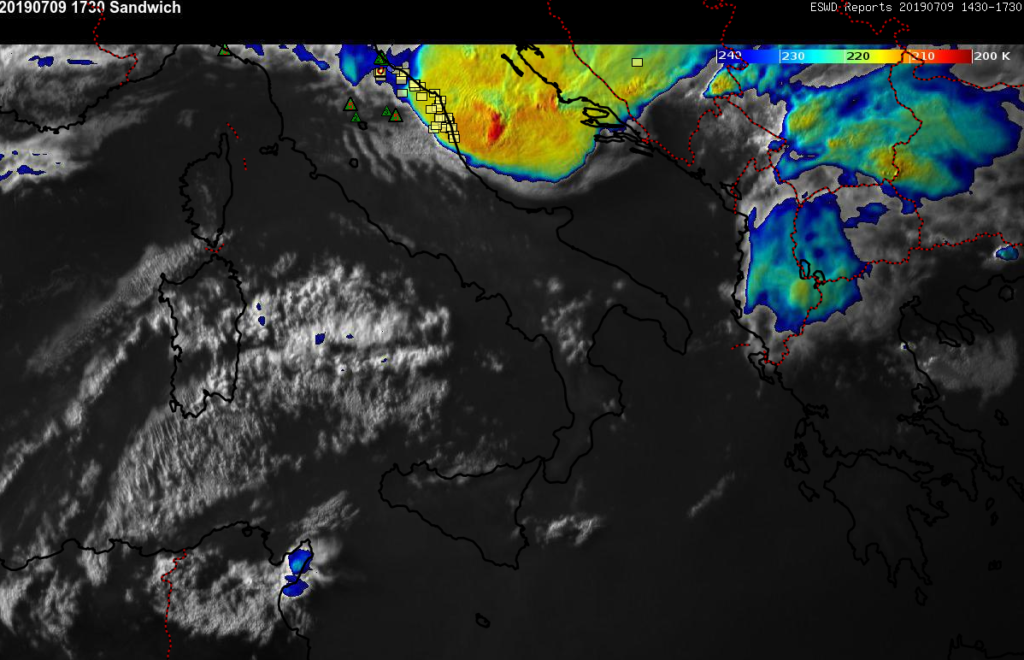
The axis of severe weather shifted more to the south on the following day, 9 July 2019. In the afternoon, isolated storms produced very large hail up to 8cm in diameter over Italy. Later on, storms clustered into a large convective system and produced swaths of damaging wind gusts, which extended over the Adriatic Sea towards Croatia, Montenegro and Albania.
9 July 2019 17:30 UTC Meteosat-10 visible and infrared – BT enhanced satellite imagery combination (sandwich) with ESWD reports from the previous 3 hours. Green triangles represent large hail (number inside indicates the diameter), yellow squares severe wind gusts and red triangles tornadoes. Two pronounced above anvil cirrus plumes are visible atop large convective system over the Adriatic Sea. Data source: EUMETSAT, ESSL.
The most societally impactful severe weather happened on the last day of the outbreak, 10 July 2019. Day started with an F1 tornado that injured 3 in Milano Marritima, Italy. By the early afternoon, the storms moved south and intensified while producing giant hail, up to 14 cm diameter, injuring 20 people in the Abruzzo region of Italy. In the afternoon, Puglia was impacted by damaging hail and wind gusts.
Subsequently, several of the storms originating over Italy crossed the Adriatic Sea and impacted first Albania and then Greece. Numerous injuries were reported to have resulted from damaging wind gusts and hail. In the evening, the Chalkidiki peninsula was particularly hard hit with 6 fatalities. Some media sources are mentioning over 100 injuries. On the same day, 2 people were also killed by lightning in northwestern Turkey.
This outbreak was quite rare, but it is difficult to say how extraordinary it was, because the ESWD only since 2006 collects observations of large hail and local severe wind gusts, phenomena that often escape detection by traditional observation networks. Analyses of severe weather conditions are showing that severe weather conditions with high CAPE have become more frequent (read more here), and are likely to increase during the century (read more here).