
We have decided to extend the deadline for the submission of abstracts for the ECSS conference (4 – 8 November, Kraków, Poland) to 10 May. To submit an abstract or register, please see https://www.essl.org/cms/european-conferences-on-severe-storms/ecss-2019/
Author Archives: Pieter Groenemeijer
The severe convective weather season of 2018 has started
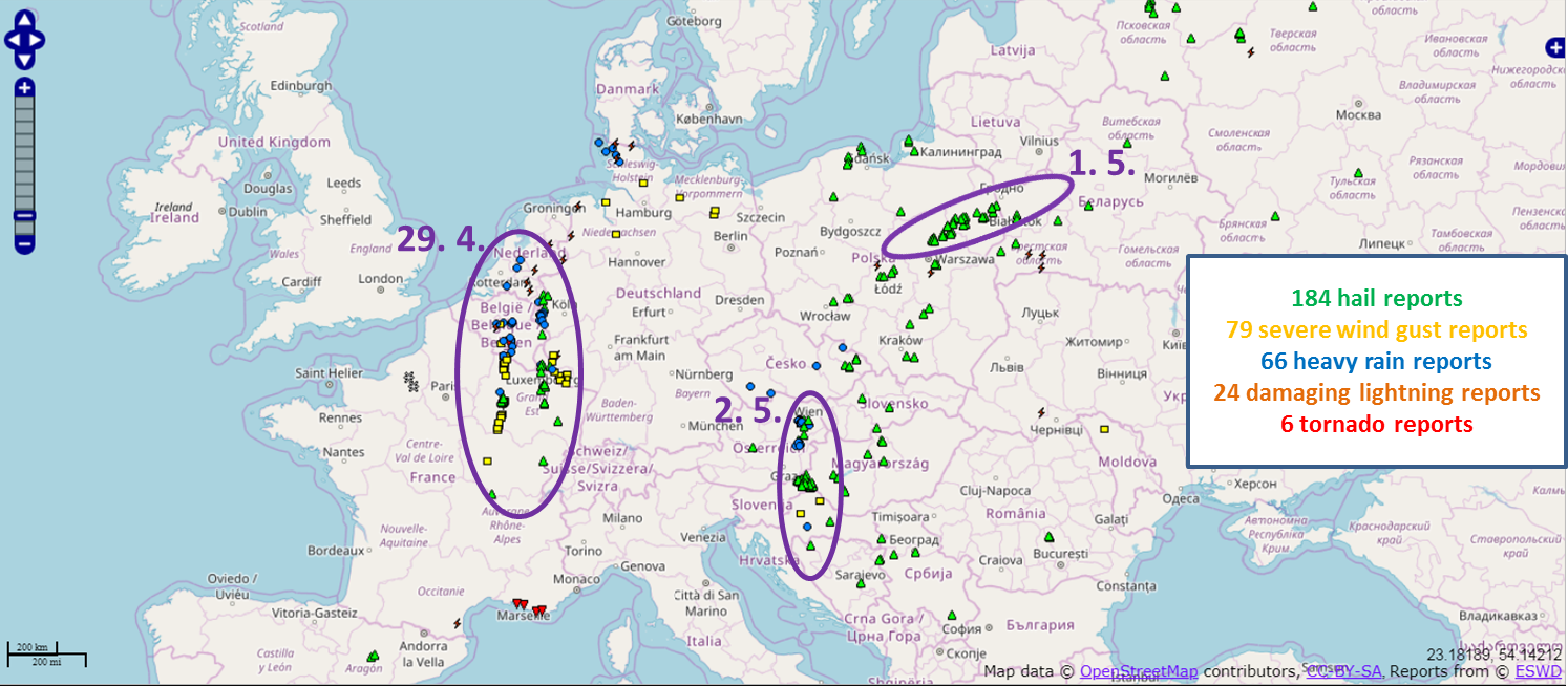
During recent days, pronounced severe convective storm activity has occurred across Europe, reports of which have been collected into the ESWD with help of ESSL’s partners. In total, we have received over 360 reports in the past 7 days. A majority of them were of large hail (184 reports), followed by severe wind gusts (79 reports) and heavy rainfall (66 reports). The first notable event was 29th April, where a tornadic supercell tracked more than 500 km from central France to Belgium. Wind damage caused by this supercell is still being investigated to confirm possible occurrence of several tornadoes along its path. On 1 May, a long-lived supercell over eastern Poland produced a hail swath 300 km long with hail up to 5 cm in diameter. And one day later, series of severe storms struck Croatia, Slovenia, Hungary and Austria. Hail up to 6 cm in diameter was observed over northeastern Slovenia, damaging houses and numerous flash floods were reported from Vienna, where storms persisted for several hours.
New statistical method shows increases in European hail and lightning
Researchers at ESSL, Munich Re, the Ludwig-Maximilians University Munich (LMU) and the German Aerospace Centre DLR have developed a new statistical method to investigate trends in thunderstorm and severe weather activity. Anja Rädler, the main developer of this method, called AR-CHaMo, will defend her Ph.D. thesis on this topic at LMU.
Anja Rädler says: “the strength of our approach is that we are now able to assess changes in severe weather frequency using climate models that are themselves too coarse to simulate each and every thunderstorm”. To do this, the probability of lightning and severe weather is determined as a function of parameters such as instability, moisture and wind shear, using severe weather observations from ESSL’s European Severe Weather Database.
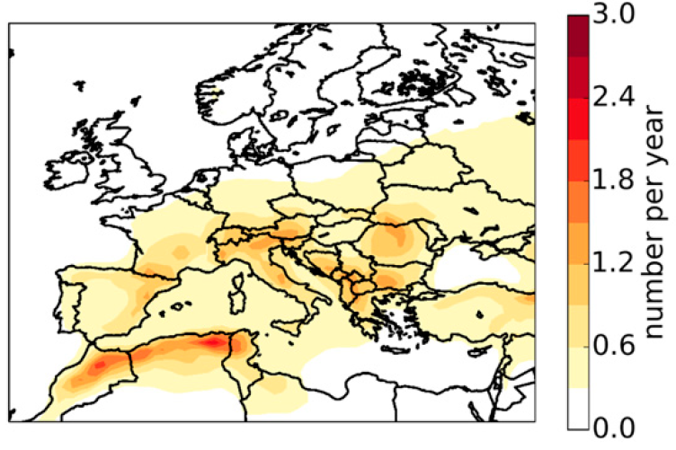
Annual number of 6-hourly periods with hail of 2 cm or larger in Europe (1979 – 2016), modelled using AR-CHaMo. From: Rädler et al, 2018.
In a new article in the Journal of Applied Meteorology and Climatology, the development of AR-CHaMo is explained in detail, and trends of lightning and severe weather frequency since 1979 are presented. The basis of these projections are a numerical model (ERA-Interim), that simulates the past weather since 1979. The annual average predicted number of large hail events (see map below) conforms quite well to what we know: the Alpine forelands are the Europe’s hailfall hotbed.
The number of simulated hail events was not constant during the last three decades. When considering hail activity over Central Europe, significant increases are detected.
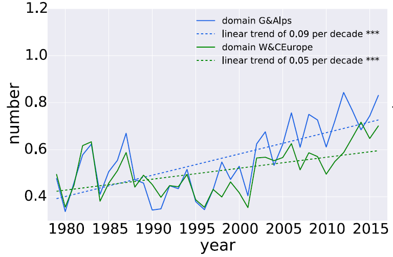
Simulated number of 6-hourly periods with hail > 2 cm across Germany and the Alps (blue) and Western and Central Europe (green), 1979-2016. From: Rädler et al, 2018.
Of course, it is of interest to know what the reason for the increase is. Anja Rädler: “we found that the driving factor is the increasing humidity close to the earth’s surface. This is something we expect to happen when temperatures increase, because warmer air can contain more moisture.” Indeed, temperature has increased since 1979, at least partly, because of the rising CO2 content of the atmosphere.
The map below shows which areas have seen the strongest increase, according to ERA-Interim and the AR-CHaMo model.
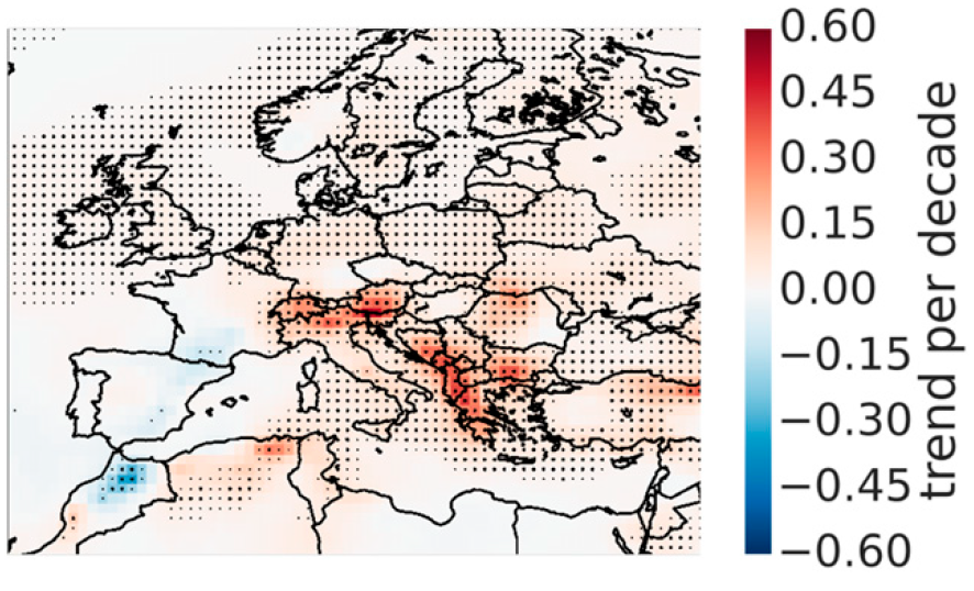
Trend of number of 6-hourly periods with severe hail of 2cm or larger (1979-2016). Dots denote where a ignificant trend was found. From: Rädler et al, 2018.
The next question Anja and her team will address is what will happen in the future. First results that were published by the ESSL team in 2017 suggest that the moisture increase will continue and create more situations favorable for severe thunderstorms during the 21st century. Using the new AR-CHaMo method, the team will soon be able to give an estimate of how much more hail, tornadoes, severe winds and lightning we should count on in different climate change scenarios.
Overview Article: 10 Years of Research at ESSL
The Bulletin of the American Meteorology Society has published an article that summarized the accomplishments of ESSL in it first 10 years of existence, such as the ESSL Testbed, Climate research and, of course, the European Severe Weather Database. Read the article on-line at:
https://journals.ametsoc.org/doi/pdf/10.1175/BAMS-D-16-0067.1
New study shows: severe thunderstorms more frequent if Europe warms and moistens
A new study led by ESSL researcher Dr. Tomáš Púčik shows how climate change will affect weather conditions responsible for severe thunderstorms. In the study, which has appeared in the Journal of Climate, no fewer that 14 regional climate models were studied. Because climate models are still too coarse to simulate convective storms directly, the researchers looked how often the three necessary ingredients for severe storms occur: unstable conditions, a strong change of wind with height, and a mechanism to trigger the storms.
The climate models predict that strongly unstable situations will occur more frequently, because the water vapour content in the lowest air layers will increase. At the same time, the wind shear, a factor important for the development of well-organized supercells, will not change much. As a result, severe convective storms are forecast to occur more frequently, with the strongest increases scenario with higher greenhouse gas emissions.
The increase is not geographically uniform and considerable uncertainty remains about the future changes in severe convective storm frequency over southwestern and southern Europe, due to a drying in the summer season.
The full open-access article can be downloaded here:
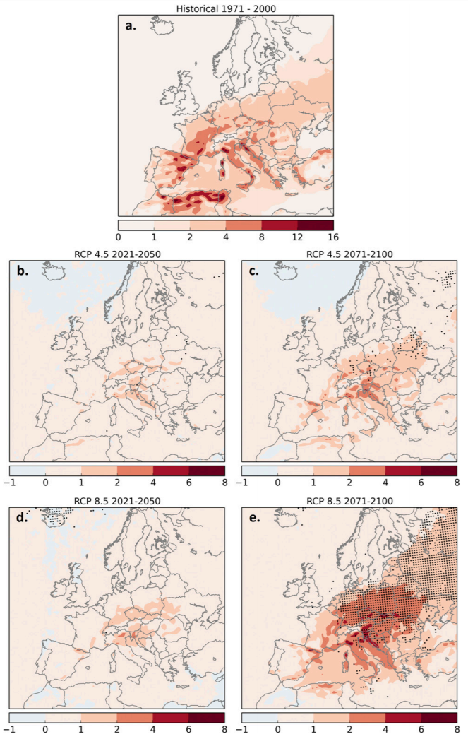
Present annual number of 6-hourly periods with high instability, strong wind shear and precipitation in the period 1971-2000 (a) and the changes expected in two future periods according to a scenario of moderate climate change (rcp4.5, b. and c.) and strong climate change (rcp8.5, d. and e.).
European Conference on Severe Storms in Pula, Croatia (September 2017)
From 18 to 22 September 2017, the ninth edition of the European Conference on Severe Storms (ECSS) will take place in Croatia. ESSL will organize the conference in collaboration with the Croatian HydroMeteorological Institute. Click here for more information…
RAIN Project projections of severe-weather until 2100: More hail, lightning and floods
Within the RAIN project, ESSL researchers Tomáš Púčik and Pieter Groenemeijer have produced projections of severe weather changes according to the EuroCordex regional climate model ensemble.
The ESSL researchers found that the consensus of the model projections suggested a 10 – 30% increase of severe convective weather events across much of Europe and 30 – 60 % in south-central Europe in the business-as-usual rcp8.5 scenario by the end of the century. These increases would be about half as large in the rcp4.5 scenario that assumes moderate climate change mitigation efforts.
RAIN project partners of the Finnish Meteorological Institute, Freie Universität Berlin and the Technical University Delft have investigated other hazards, such as wind storms, floods, forest fire and winter weather.
For more information on the RAIN project, projections of other hazards, and a link to the full report:
Read the latest ESSL Newsletter
European Weather OBserver app launched!
ESSL has lauched a free app called EWOB (European Weather OBserver) with which one can report and monitor the weather situation around oneself by viewing the reports of others. With the app, you can send a picture along with your report and to share it on Facebook or Twitter. By developing EWOB involves the public in collecting important “big data” regarding severe weather that will help weather forecasters, researchers and risk modellers to improve preparedness against severe weather.
To get the app, search for EWOB on Google Play or in the App Store!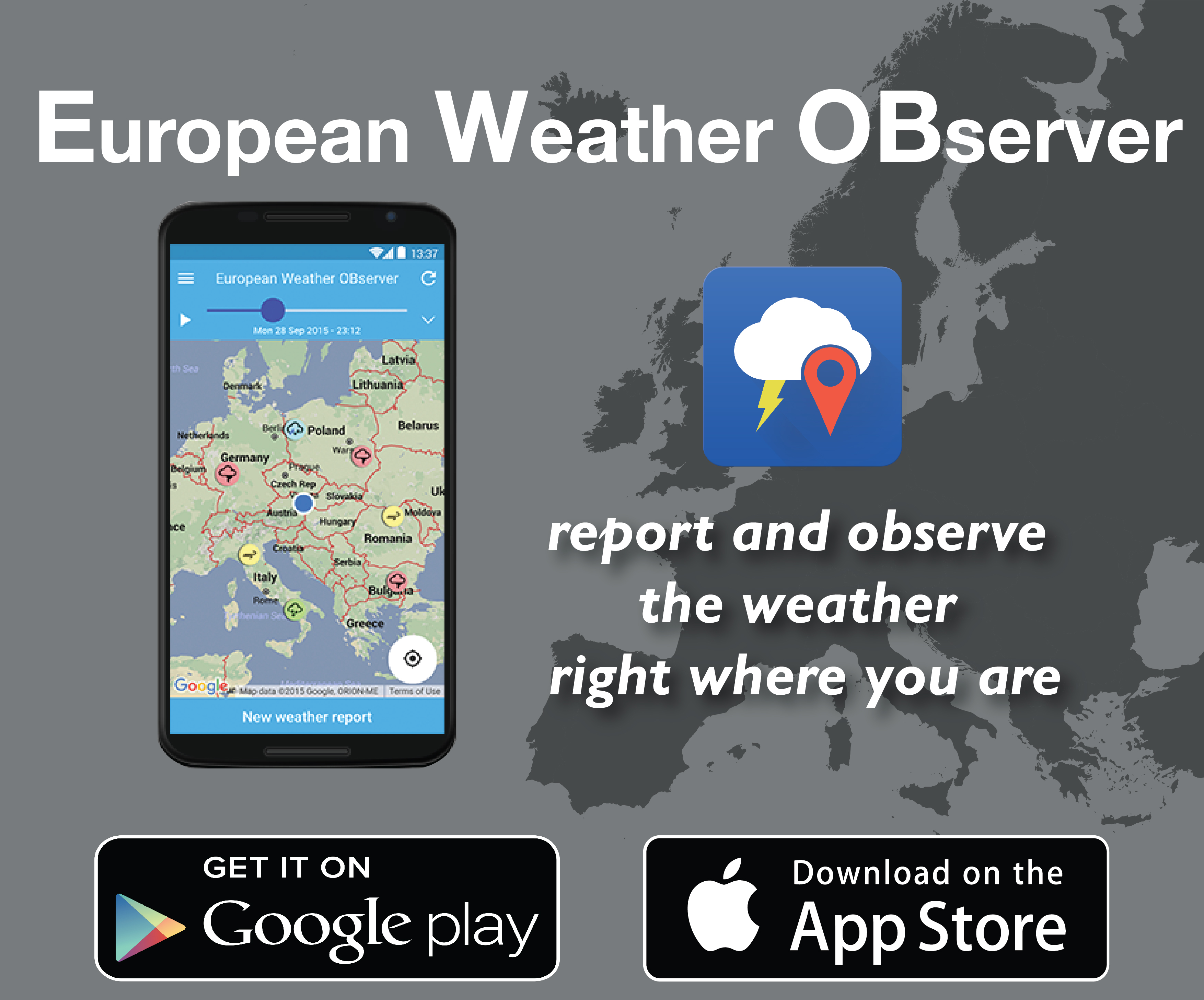
The latest reports you can also see on our web map here.
ECSS letters of schedule sent out
The scientific programme committee of the ECSS was very active during April and May checking all the submitted abstracts. The letters of acceptance were sent out on 28 May to those who submitted abstracts for the conference. The letters of schedule (including the type of presentation – oral or poster) were sent out on 7 June 2015.
The conference will take place in Wiener Neustadt, located just south of Vienna between the Alps and Lake Neusiedl, and easy to reach from Vienna airport. We expect an exciting week that will feature all aspects of severe storms, ranging from their forecasting to climatological aspects and from storm detection by radar and satellite to their impacts.
Confirmed keynote speakers include Greg Carbin (Storm Prediction Center, Norman, OK) and George Bryan (UCAR, Boulder, CO).
On Wednesday, a panel discussion will address the challenges of storm forecasting in Europe.
In addition, there is an extensive programme of social side events. The Local Organizing Committee and the Scientific Programme Committee are looking forward to welcome you in September in Wiener Neustadt.