ESSL and collaborators drafted a document on the “International Fujita Scale” (IF-Scale). It defines a new method to rate tornado and wind damage and was presented at the European Conference on Severe Storms in Bucharest, Romania, earlier this month.
The document is open for commenting until 31 May 2023. ESSL plans to implement the new scale in the European Severe Weather Database by 1 July 2023.
More information on the IF-Scale draft you can find here.
The workshop is scheduled for autumn, from 16 to 18 October 2023, and takes the very broad view. Target audience are forecasters (“warners”) and heads of forecasters, researchers and practicioners related to warnings, civil protection authorities, and end users of warnings (especially from critical infrastructure).
The following topics will be covered:
The broad
multidisciplinary view: risk ethics (philosophy, moral reasoning), human
behaviour (psychology) and legal frameworks (just) in the context of the
warning process
Limitations
and new prospects for ingredients-based warning approaches: How should the risk
matrix be defined? Can more life be brought to forecasting impacts beyond the
marketing term?
Communication
– dealing with uncertainty: Why is there so little progress in communicating
the warning uncertainty, and how can this be improved?
Action
advice and public education: from understanding to response and action. We are
seeking for good practice examples.
General
and tailored warnings: What are the necessary differences? And how can the gaps
between warners, emergency managements and end users be best bridged?
From
physical ingredients to impact warnings: Are impacts in high-end meteorological
events easier to predict and stronger tied to the physical magnitude than in
more frequent and modest events?
A critical
moment in the meteorological sphere: transition from forecasting to nowcasting
and the resulting potential sudden jump in probability of extremely rare
events. Should there be a stronger focus on the warning means in the “last
hour”? When in time and at which probability and intensity threshold should
sirens and other “strongly interrupting and potentially also frightening” means
of warning be used?
Cross-institutional
and cross-border communication: What is needed to ensure the flow of relevant
information in extremely time-critical and high workload situations?
Warners at work at the EUMETSAT-ESSL Testbed 2022
A detailled invitation can be downloaded here (PDF).
The registration for the 11th European Conference on Severe Storms is open and normal registration fees apply until 7 April. Starting 8 April, late registration fees do apply.
Please register here for on-site participation or online streaming (remote presentations are not foreseen).
General information on the ECSS including the scientific and social programme can be found here.
This webinar features key 2022 results from the joint
ESSL-EUMETSAT activity introducing MTG data to operational weather forecasters
in Europe. ESSL trainers describe highlights of severe convective weather cases
that were analysed by forecasters during the testbeds in Wiener Neutstadt.
Forecasters provide testimonials on their testbed experience and the importance
of satellite products in the forecasting process. In addition, the ESSL expert
workshops put the spotlight on novel MTG products such as the 0.9um FCI channel
to detect low-level moisture, or the Lightning imager. The audience will learn
about key take-aways from these workshops, for later use in training on MTG for
all users.
The Nikolai
Dotzek Award goes to three meteorologists with focus on satellite studies. The most prestigious award in the
global severe weather research community is presented every second year in the
memory of ESSL’s founding father, Dr. Nikolai Dotzek, for an outstanding
contribution to the science of severe storms.
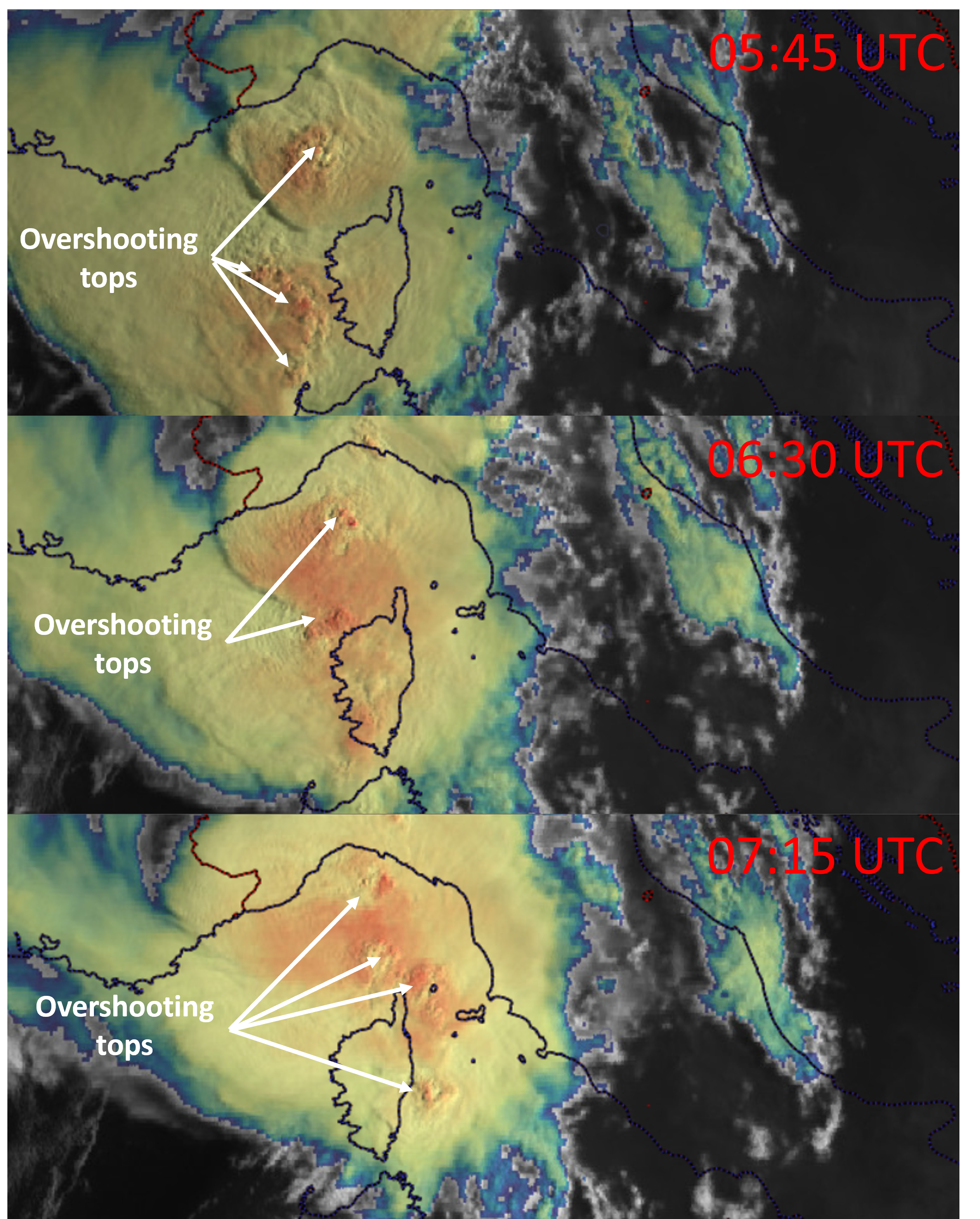
As the new generation of satellites in Europe, the United States, and Japan have been launched, their increased capabilities in terms of available channels and resolution will allow for better nowcasting of severe convective storms. It is a good time to acknowledge those who have contributed significantly to our understanding of the processes that occur on top of the convective storms, how they relate to storm severity, and how they can be operationally detected. ESSL presents the 2023 Nikolai Dotzek Award to three scientists who have strongly pushed satellite meteorology forward.
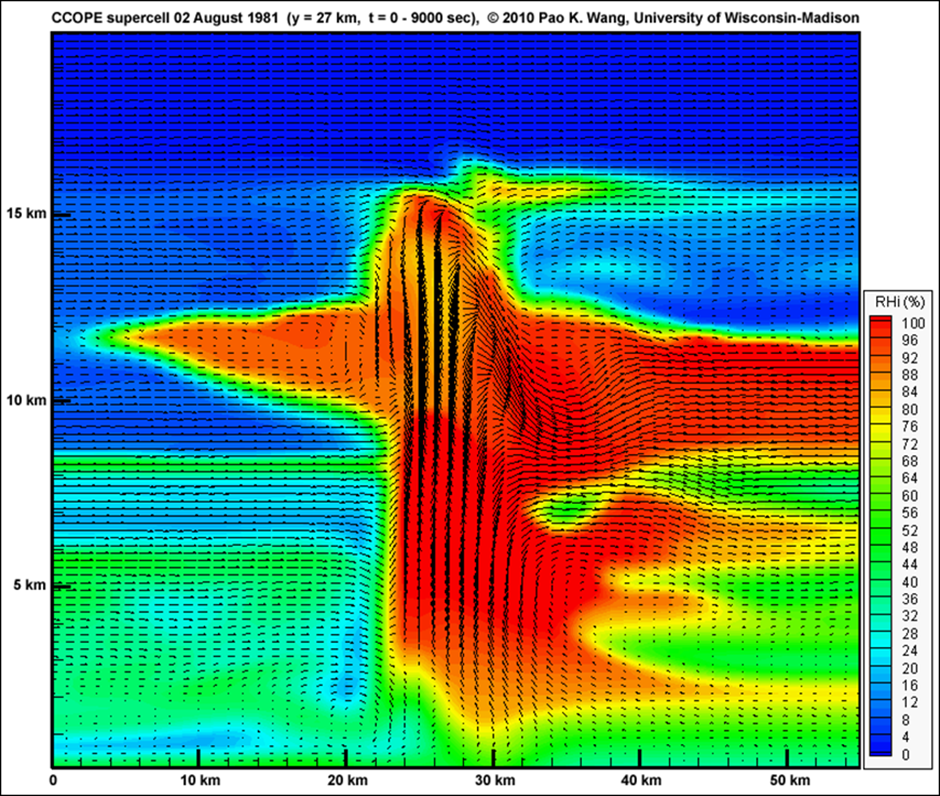
Pao Wang
The first awardee
is Prof. Pao-Kuan Wang, who has used very high-resolution cloud models to
simulate the processes at the top of convective storms. Simulations showed that
overshooting tops act as obstacles to the anvil-relative wind. Thus, most of
the storm top features that we observe from a satellite, such as cold rings,
cold-Us, above-anvil cirrus plumes, storm-top gravity waves or ship wave
patterns result from the interaction between overshooting tops and the ambient
flow. Wang has also shown that some of these features result from internal
gravity wave breaking processes, consequently contributing to lower
stratospheric moistening. Wang was, until recently, director of the Research
Center for Environmental Changes of the Academia Sinica and formerly professor
at the University of Wisconsin in Madison.
Numerical simulation of a supercell showing the development of above-anvil cirrus plume as an example work of Pao Wang.
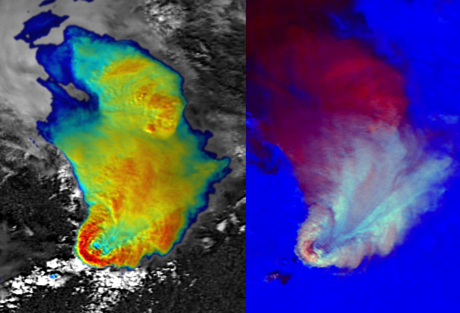
Martin Setvák
The second awardee is Dr. Martin Setvák, who in the late 1980’s described various forms of increased 3.7 micron cloud top reflectivity of convective storms and discussed its possible link to storm severity and updraft strength. Later he elaborated this concept with Dr. Charles A. Doswell. Together with Dr. Vincenzo Levizanni, Setvák formulated a concept of above-anvil cirrus plumes above convective storms on satellite imagery. He also contributed to the categorization of various storm-top phenomena, such as cold rings, closely collaborating on these topics with Prof. Pao K. Wang. Setvák is the father of the so-called “sandwich imagery”, a combination of infrared and visible channels, which is now in widespread use across the world. Martin Setvák has formally retired but still works part-time at the Czech Hydrometeorological Institute (CHMI).
NOAA-9 AVHRR imagery of an extremely severe hailstorm on 18 August 1986 over central Czechia clearly shows an above-anvil cirrus plume. This was one of the first storms of which the presence of the plume was noted by Martin Setvák.
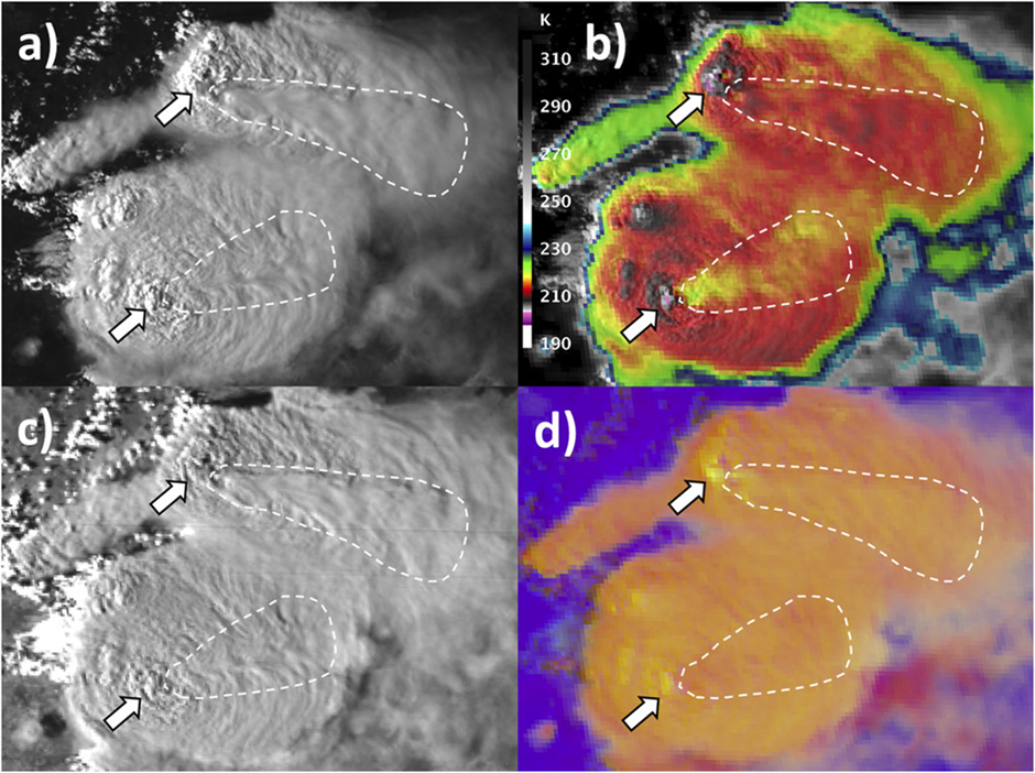
Kris Bedka
The third awardee is Kristopher Bedka, who together with his team made significant strides toward the automation of the detection of both overshooting tops and above-anvil cirrus plumes. Using large records of these phenomena and their properties, Bedka investigated their statistical relationships with severe weather beneath them. His recent work concentrated on the automatic detection of high ice water content in deep convective storms, adversely impacting aircraft engine and air probe performance. He demonstrated the utility of 1-min super rapid scanning for analysis of satellite-observed cloud properties. His ongoing work expands towards wind profiling with an airborne doppler aerosol lidar – to only mention one of several fields of activity – and offers great promises for nowcasting and improving severe storms climatologies. Kris Bedka is affiliated with the NASA Langley Research Center.
An example from Kris Bedka’s work: Above-anvil cirrus plumes at the top of severe convective storms over Argentina on 8 February 2018. The northern one produced hail exceeding 18 cm.
The Nikolai Dotzek
Award trophy represents a massive hailstone. The prize money is 1000 EUR
together with an invitation to the European Conference on Severe Storms (ECSS).
The award was instigated by the European Severe Storms Laboratory (ESSL) in
2011. The handing over of the award trophy usually crowns the dinner of the
ECSS conference and will take place this year in Bucharest, Romania, on the
10th of May.
Nikolai Dotzek Award trophy
The ESSL aims to contribute to the preparedness of European society for the impacts of severe storms by advancing scientific understanding, building human capacity, and fostering cooperation within Europe in this field.
ESSL provides training to forecasters, scientists, and policymakers on topics related to convective weather. ESSL participates in research projects and organizes the European Conference on Severe Storms to improve and stimulate the exchange of knowledge on severe convection. ESSL aims to establish and maintain close relationships with national weather services and research institutes to strengthen pan-European collaborations. ESSL maintains the European Severe Weather Database, to support research based on observations of severe convective weather or any related impact.
You can download a PDF document of this content here.
More information on the Nikolai Dotzek Award can be found here.
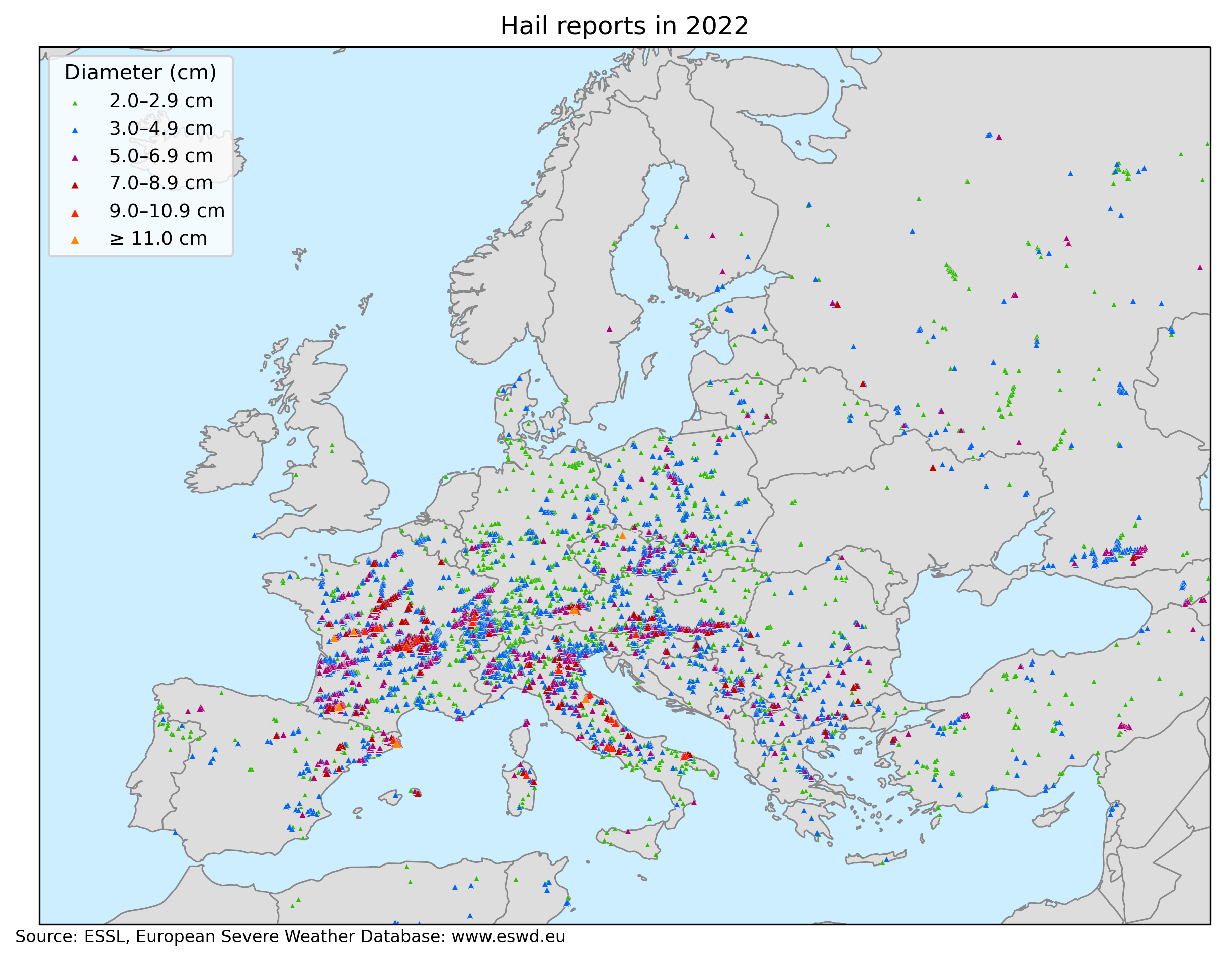
The year 2022 was another record-breaking year for hailstorms in Europe. In total, 8224 large hail reports (≥ 2 cm in diameter) were submitted to ESWD. That is 2791 more than in 2021, which was already a record-breaking year. Very large hail (diameter ≥ 5 cm) was reported 1334 times and 18 reports involved giant hail with a diameter ≥ 10 cm. There were 213 days with at least one large hail and 94 days with at least one very large hail report. The period of 20 May to 10 July was particularly active concerning very large hail. Out of 52 days, very large hail was observed on 42 of them.
Large hail reports in Europe in 2022 based on the European Severe Weather Database.
By far the largest number of reports was submitted for France (2461), followed by Italy (993) and Germany (583). The three days with the most hail reports were 4 June (411 reports), 20 June (385 reports), and 25 May (334 reports). Hail injured 215 people and killed 1. The two most societally impactful events were the Casamassima (Italy) hailstorm on 19 August with 100 injuries and the La Bisbal d’Empordà (Catalonia) hailstorm on 30 August with 67 injuries and one fatality. Hailstorms had a very large economic impact, especially in France, where the insured losses reached 4.8 billion € according to Swiss-Re. While some of the hailstorms produced large hail only for 15 minutes, some lasted for more than 3 hours. The longest-lasting hailstorm occurred on 22 May in France, producing large hail for 5 hours in a hail swath over 300 km long.
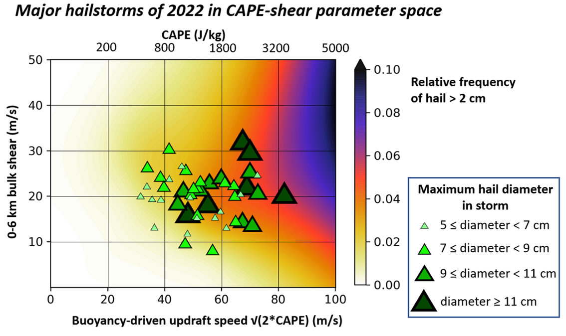
Major hail events of 2022 formed in a large range of CAPE and shear values. That said, the majority of the events occurred with CAPE exceeding 1000 J/kg and 0-6 km bulk shear exceeding 15 m/s, which is a parameter space where the large hail typically occurs. Some of the giant hail-producing events had a rather unremarkable environment. A good example of such a case is the hailstorm of 1 July over Czechia, which produced hail up to 11 cm in diameter with CAPE around 1000 J/kg and 0-6 km bulk shear well below 20 m/s. Giant hail was produced briefly following the merger of two storms. Hail around 3 cm in diameter was observed pre-merger and no large hail followed the brief period of giant hail production. This shows the importance of storm-scale processes, which can’t be captured by looking at the large-scale environment.
Major hailstorms of 2022 in CAPE and 0-6 km bulk shear parameter space based on the ECMWF data. Background colors represent the relative frequency of hail > 2 cm acquired from the additive logistic regression model ARCHaMo for large hail (Battaglioli et al. 2023, submitted).
The biggest hailstorm cases of 2022:
20 May: Several hailstorms impacted northern France and western Germany. The largest hail, 8 cm across, fell in Sedan, France. Most hail damage was produced by a hailstorm that passed the northern suburbs of Koblenz, Germany, damaging roofs, windows, and cars. The largest hail reached 6 cm there.
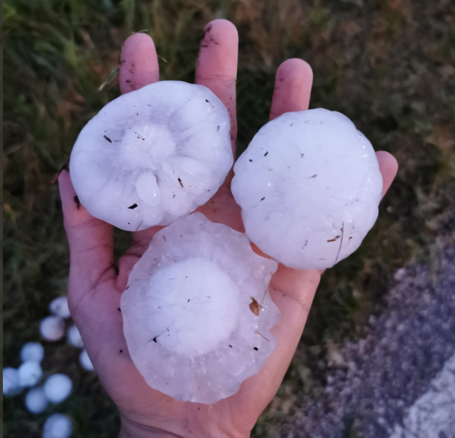
22 May: A supercell tracked for more than 300 km across west-central France, impacting the towns of Niort, Poitiers, Chauvigny, and Chateauroux. Supercell produced hail for 5 hours with several peaks of activity, when the hail diameter exceeded 8 cm in diameter. The largest measured hail was 12 cm in diameter, but even larger may have fallen with reports of weight up to 780 g. Chateauroux was hard hit with hailstones up to 9 cm in diameter. 4 people were injured and the hail badly damaged 250 houses and 1000 cars.
One of the giant hailstones that fell on 22 May in France. Source: https://www.francebleu.fr/infos/faits-divers-justice/en-images-a-frontenay-rohan-rohan-des-grelons-comme-des-oranges-1653307396
25 May: Several supercells produced long hail swaths over southeastern Austria, Slovenia, northeastern Croatia, and Hungary. The largest hail measured 8 cm in diameter. Severe damage to buildings was reported in Kapela Podravska, Croatia, and Kiskorpád, Hungary.
28 May: South-moving hailstorm produced damage east of Milan. The largest hail reached 7 cm in diameter. A hail up to 8.5 cm in diameter was reported in the Smolan region, Bulgaria, damaging cars, roofs, and agriculture.
29 May: A woman was injured by very large hail in Italy. Hail up to 7.5 cm in diameter caused significant damage to roofs, cars, and greenhouses in Orizari, Bulgaria.
2 June: Severe hailstorms impacted southeastern Austria, Slovenia, and northern Croatia. Damage to crops, houses, and cars was reported. The maximum hail size reached “only” 5 cm, but hail fell in large quantities and was accompanied by severe winds in many locations with drifts up to 20 cm deep.
3 June: Hailstorms affected southern France. The largest hail measured 7.5 cm in diameter and the longest hailstreak was 150 km long.
4 June: Widespread hail damage was reported in central France, particularly in Vichy and surrounding areas. Hail reached up to 10 cm in diameter, severely damaging cars, roofs, and agriculture. 1 person was injured by hail in Vichy.
5 June: Hailstorms impacted eastern France, Switzerland, northwestern Italy, Slovenia, Austria, and Serbia. Hail up to 9.5 cm was reported in Frankolov, Slovenia, and an 11 cm hailstone fell in Kufstein, Austria.
19 June: A long-lived, right-moving supercell produced an almost 350 km long hail swath across France, affecting the outskirts of Orléans. The supercell produced hail for 4 hours. Roofs and cars were damaged along the path of the storm and the largest hail, measuring 8.5 cm, fell in Chambord and Saint Cyr en Val.
20 June: A long-tracked supercell crossed northern Bordeaux and destroyed more than 5000 hectares of agriculture with wind-driven hail in Dordogne. The largest hail diameter reached 7 cm. Serious damage to roofs and cars was reported in some parts of the hail swath. North of Pyrennees, a hailstorm produced giant hail with a maximum estimated hail size of 13 cm in Vic en Bigorre with widespread damage to roofs and cars. Long-lived supercells with hail also affected southern Germany and southeastern Czechia, but hail did not reach 5 cm.
21 June: Third day of severe hailstorms in France in a row. Wind-driven hail up to 9 cm in diameter impacts regions of Auvergne and Bourgogne, destroying agriculture, roofs, windows, and cars. House facades and sides of cars suffered extensive damage as the hail was blown horizontally in the strong wind. A video showing the combination of severe winds and very large hail can be found here. Another long-lived supercell produced hail up to 8 cm, severely damaging roofs and cars in the region of Morvan. Very large hail also fell in Italy, Slovenia and Serbia. In Serbia, hail up to 7 cm in diameter caused severe damage to agriculture and roofs in the Moravički region.
Damage to the vehicles by the wind-driven hail in Digoin, France. Photo taken by Christophe Asselin (Chroniques Chaotiques).Damage to the vehicles by the wind-driven hail in Digoin, France. Photo taken by Christophe Asselin (Chroniques Chaotiques).
23 June: Hail and windstorm impacted Podgorica, Montenegro with damage to agriculture and cars. Largest hailstones reached 5.5 cm. Hail up to 8 cm in diameter was observed in Sfélinos, northern Greece.
26 June: Severe hailstorms affected eastern France with hail up to 7 cm in diameter. One of the storms also impacted Strassbourg and its outskirts and many cars were damaged.
27 June: Very large hail up to 8 cm in diameter was reported from southern Germany as two supercells tracked along the northern edge of the Alps. 7 cm hail was reported in western Czechia.
28 June: 1 person was injured by very large hail in Kastoriá, Greece.
29 June: Widespread large to very large hail was reported in eastern Czechia and southern Poland.
30 June: Very large hail fell in France, Italy, northern Czechia, Poland, and Bosnia-Herzegovina. The largest hail, 8.5 cm across, was reported in Blamont, France.
1 July: Giant hail up to 11 cm in diameter fell in Rovensko pod Troskami, Czechia. Very large hail also fell in eastern Czechia and western Slovakia from two long-lived supercells. Splitting supercells produced hail up to 6 cm in diameter in the Veneto region, Italy.
5 July: Severe hailstorm impacted southwestern Serbia. Hail up to 7 cm in diameter damaged crops, roofs and cars.
4 July: Very large hail up to 6 cm in diameter injured 2 in Castel Maggiore.
7 July: Several supercells formed in Veneto, Lombardia, and Emilia-Romagna regions in Italy, each producing very large hail. Widespread damage to cars, windows, and roofs was reported. The largest hail fell in Ostiglia and was estimated to be 9 cm in diameter.
Very large hail that fell in Revere-Ostiglia area on 7 July. Photo taken by Luca Vezzosi.
20 July: Severe hailstorms occurred in Switzerland and eastern France. The most severe storm affected the region of Franche-Comté and the commune of Doubs, where hundreds of roofs, windows, and vehicles were badly damaged. The largest hailstone fell in Le Russey, estimated at 9 cm across.
27 July: Very large hail was reported from the Abruzzo province in Italy. The largest hail, 9 cm in diameter, fell in Teramo and Ascoli Piceno. Damage to cars, roofs, and windows occurred.
28 July: Left-moving supercell produced very large hail up to 8 cm in diameter near Lleida, Spain, damaging roofs, cars, windows, and greenhouses.
13 August: Southward moving supercell produced a long hail swath across Sardegna, a rather rare occurrence on the island. The largest hail was estimated to be 9 cm in diameter and fell in Alà dei Sardi.
17 August: Widespread large to very large hail was reported from southern France. The largest hail fell in Bonnétage, estimated at 8 cm across. In Catalonia, a woman was slightly injured by a 5 cm hailstone.
18 August: The event known especially for the powerful derecho producing wind gusts exceeding 60 m/s over Corsica also featured a number of damaging hailstorms. In the early morning hours, wind-driven hail injured 22 people in Sestri Levante and Lavagna in Liguria, Italy. Hail damaged cars, windows, and facades of houses. Around noon, a hailstorm struck Menorca with hail up to 7 cm in diameter. In the evening hours, another series of hailstorms impacted Italy, especially the regions of Marche and Tuscany. The largest hail, 11 cm in diameter, fell in Macerata Feltria damaging cars, and roofs and injuring 1 person.
19 August: Giant hail, reaching 10 cm in diameter, was reported from Casamassima, damaging cars, and windows. At least 100 people were lightly injured by hail. Most of the injuries were inflicted by broken glass. The number of injuries ranks as the third highest recorded in the ESWD for large hail events.
Very large hail that fell on 19 August in Italy. Photo taken by Michele Connena.
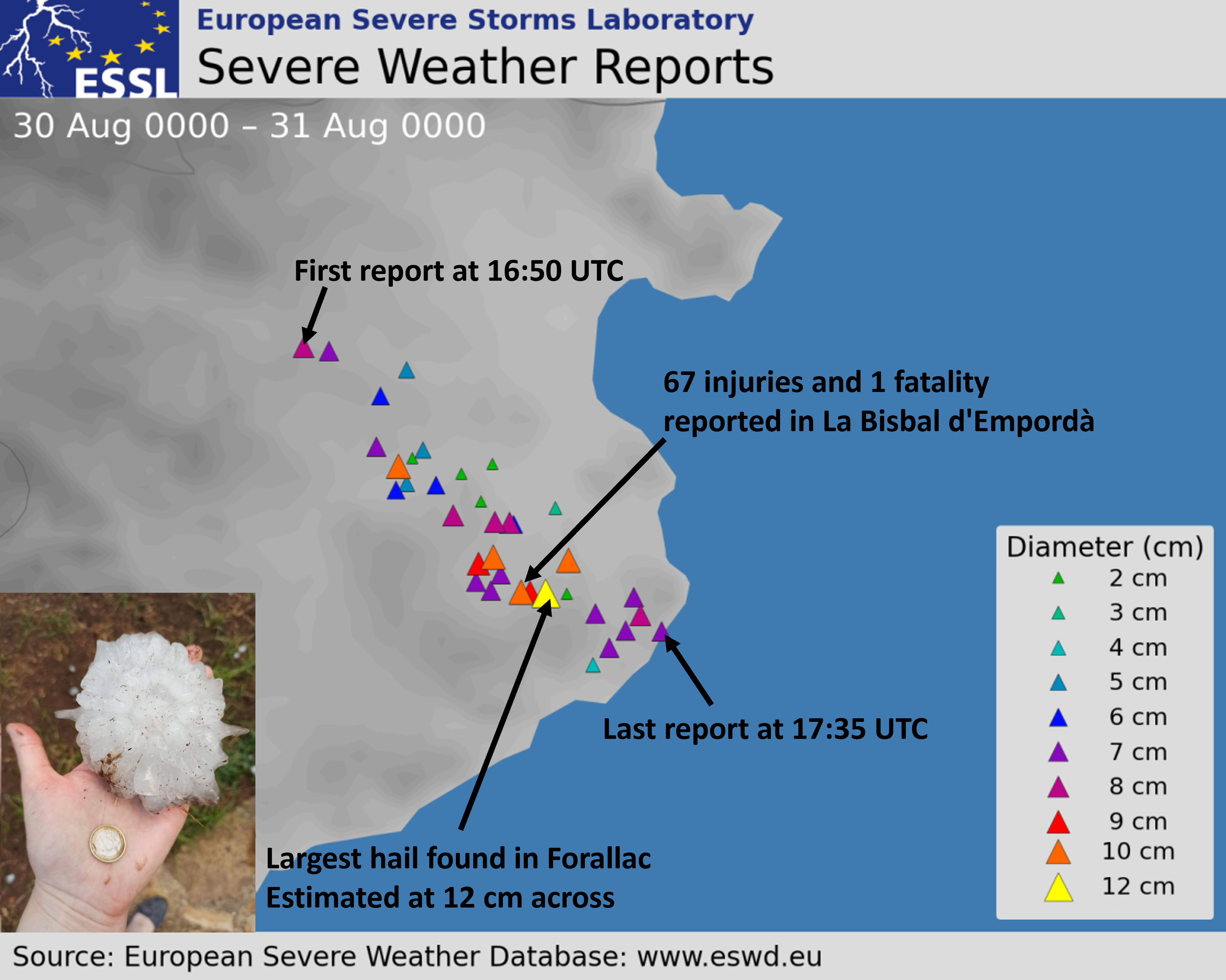
30 August: In the late afternoon, a supercell storm formed over the eastern Pyrenees. The storm moved southeastward and entered the district of Girona in Catalonia, producing a swath of very large hail (≥ 5 cm) between Esponnellá and Tamariu. Multiple reports of hailstones larger than 10 cm in diameter were collected with the largest stones estimated to be 12 cm. Impressive videos of the hailfall can be found here or here. Besides serious damage to roofs and cars, 67 injuries and even one fatality (a 2-month-old baby) resulted in the town of La Bisbal d’Empordà. 28 people had to be taken to the hospital, including one serious head injury. This was the first direct hail fatality in Europe since 1997. Furthermore, the number of injuries ranks as the fourth highest recorded in the ESWD for large hail events.
Giant hailstone that fell in Catalonia on 30 August 2022. Source: https://mobile.twitter.com/Supercelulas
8 September: Southeastward moving supercell over Lazio, Italy produced a swath of very large hail. The largest hail, 9 cm across, fell in Boville Ernica.
27 September: Serious hail damage to roofs, cars, windows, and greenhouses was reported from Serbia, especially in Pomoravski okrug region. Hail reached up to 6 cm in diameter.
23 October: Intense storm that resulted in a long-tracked tornado in Haute-Normandie, northwestern France also produced very large hail up to 7.5 cm in diameter.
We cordially invite you to submit a contribution to the 11th European Conference on Severe Storms to be held from May 8th to 12th in Bucharest, Romania.
20 January 2023 will be the final deadline for abstract submission.
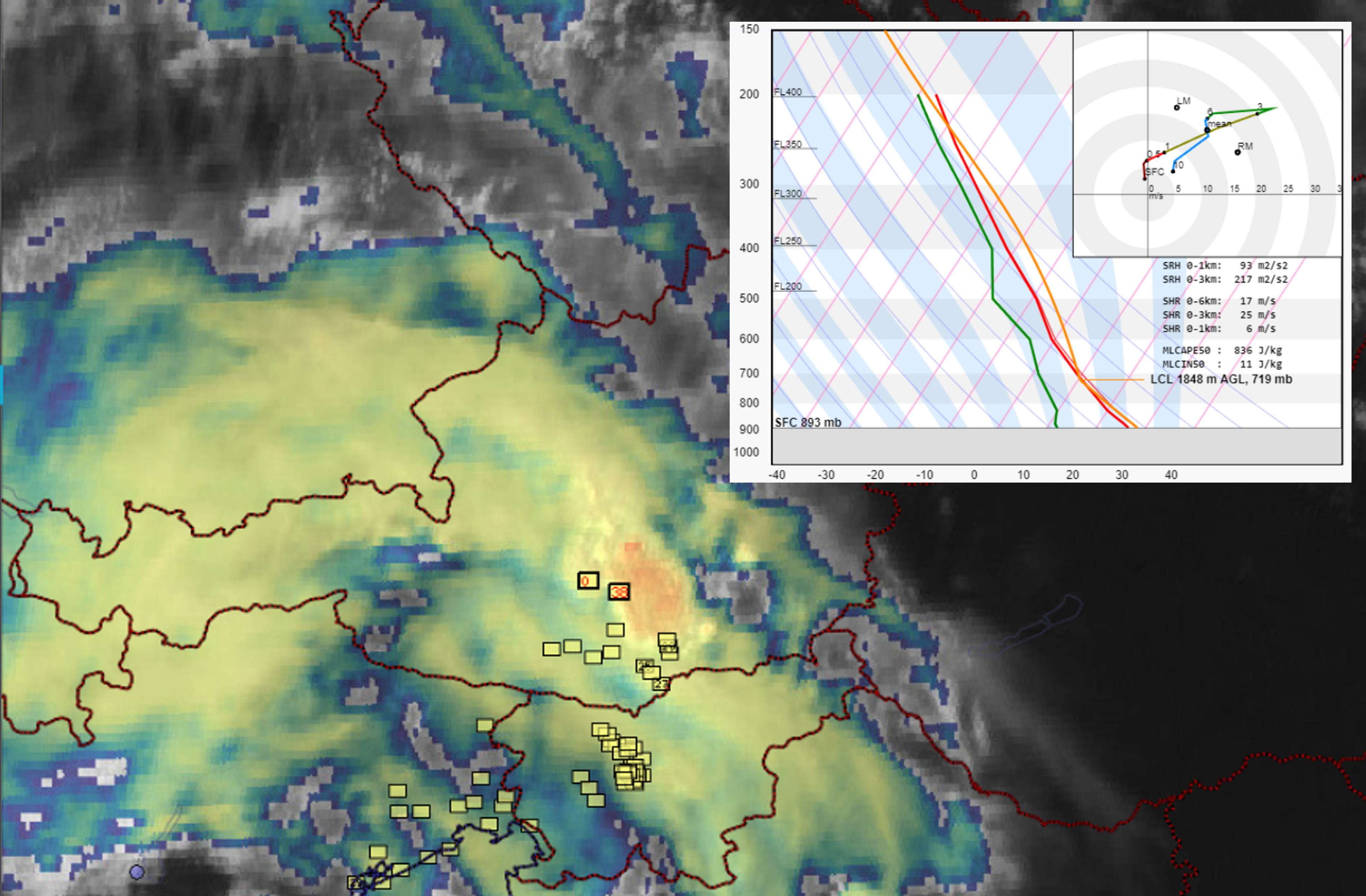
In the late afternoon of 30 August 2022, an extraordinary supercell storm formed over the eastern Pyrenees. The storm quickly started to move to the right of the mean wind as it entered the district of Girona in Catalonia, producing a swath of very large hail (≥ 5 cm) between Esponnellá at 16:50 UTC and Tamariu at 17:34 UTC, after which it moved over the sea.
Sandwich satellite image of the hailstorm over Northeast Catalonia on 30 August 2022 at 17:30 UTC, and surface station measurements of the wind, temperature (red), and dew point (green).
Multiple reports of hailstones larger than 10 cm in diameter were collected with the largest stones estimated to be 12 cm. Based on some videos, the hail fall was relatively dense for stones of that size. The impacts of the storm were high: Besides serious damage to roofs and cars, 67 injuries and even one fatality resulted in the town of La Bisbal d’Empordà. 28 people had to be taken to the hospital, including one serious head injury. Based on our study on hail impacts across Europe, this was the first direct hail fatality in Europe since 1997. Furthermore, the number of injuries ranks as the third highest recorded in the ESWD for large hail events.
Given the societal and economic impact of this hailstorm and the fact that the giant hail has already been reported 18 times in Europe this year, we look at the predictability of this particular event from the perspective of the large-scale, pre-convective environment addressing these two questions:
How likely was the convective initiation?
How likely were the initiated storms to produce giant hail?
Limiting ourselves to the large-scale environment we do not address two important sources of data: high-resolution convection-allowing models and nowcasting data, such as products based on radar
How likely was the convective initiation?
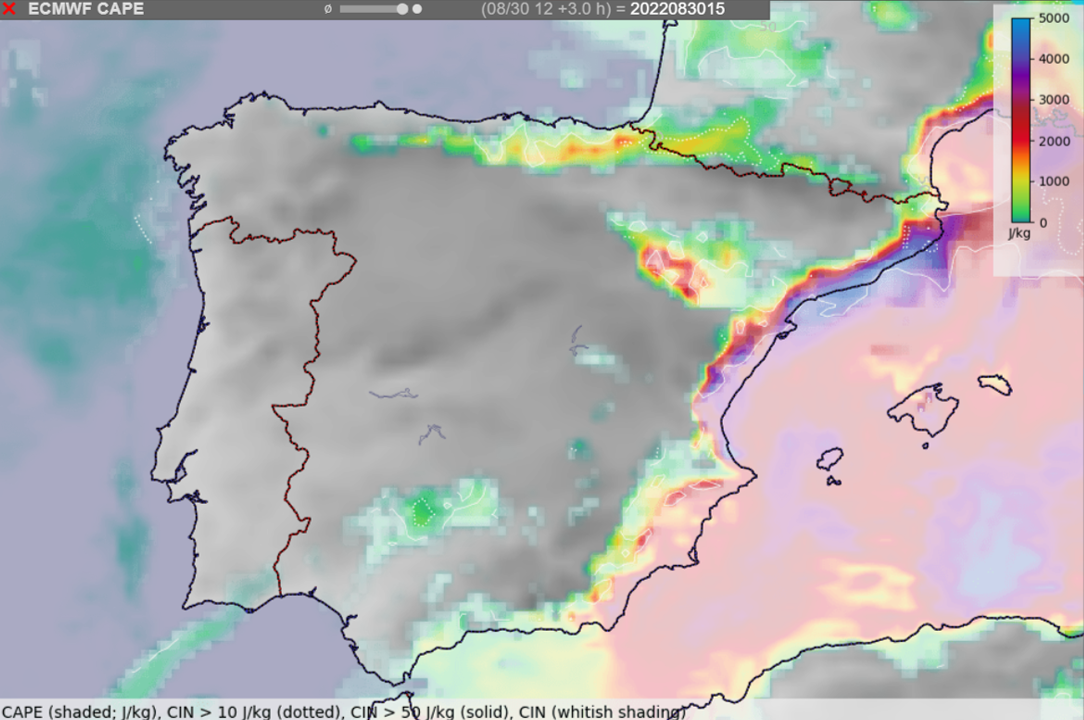
With an abundance of low-level moisture along the coastline and steep mid-tropospheric lapse rates advected from the interior of Iberia, high convective available potential energy (CAPE) was present to support the development of severe thunderstorms.
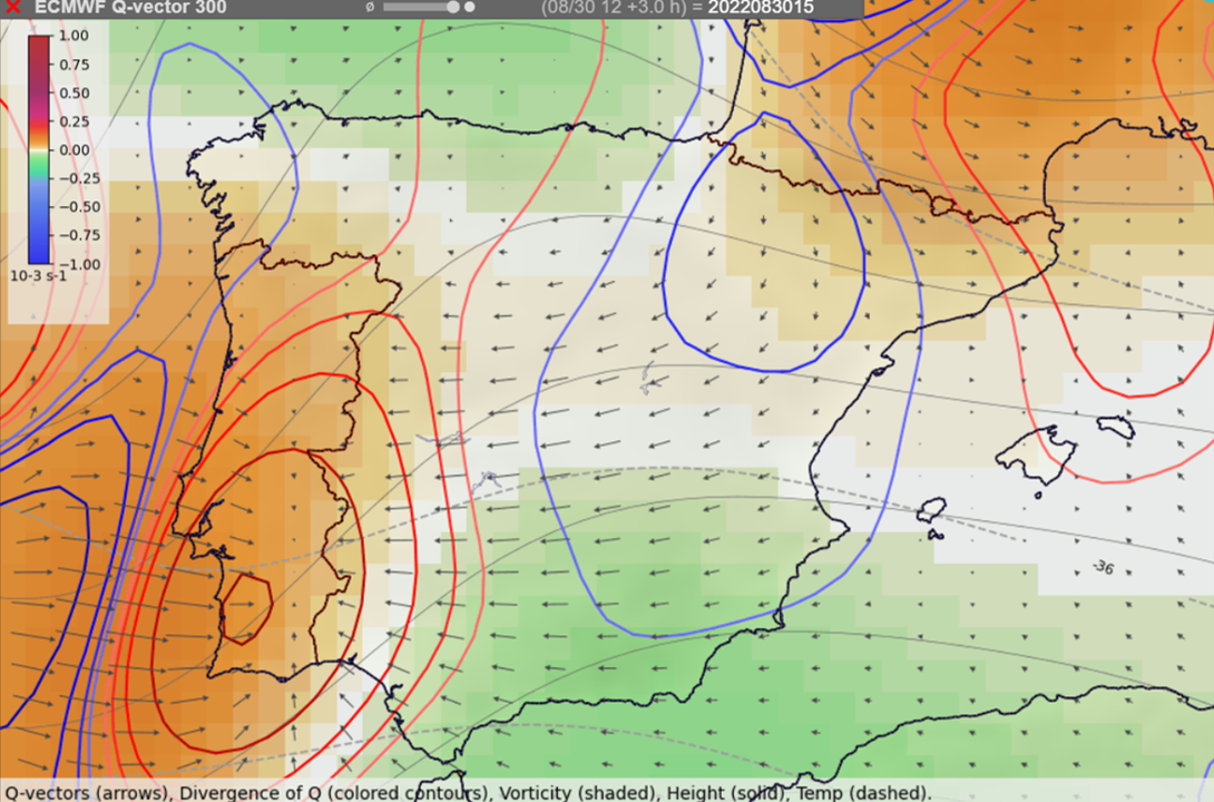
With this potential being present, the most important question was if a trigger strong enough to set this energy free would be available in this environment. The synoptic-scale lift was forecast only over extreme northeastern Spain and in the upper troposphere near 300 hPa, but not at lower levels. With the absence of fronts or other large-scale air-mass boundaries, the mesoscale lift had to come from an upslope flow of maritime air against the high terrain.
Locations of where large-scale upward (red contours) and downward (blue contours) vertical motion is to be expected based on Q-vectors at the 300 hPa pressure level.
Convective initiation across Spain was complicated by a substantial amount of convective inhibition (CIN), negative energy to be overcome before a storm can form, especially over the southern part of Iberia. Near the eastern coastline, CIN rapidly increased from the mountains towards the coastline, restricting the ability of the storms to tap into the moisture- and CAPE-rich air mass. The largest area of relatively low CIN (< 50 J/kg) existed over far northeast Iberia, where the supercell formed.
Combining the lowest CIN and the presence of at least some synoptic-scale lift over far northeast Spain, with hindsight it is possible to pinpoint this area as one with the highest probability of storm formation. Severe hailstorms are often isolated cells, rather than storms which are embedded in a larger convective system. On the 30 of August, the absence of widespread mesoscale lift and the presence of some CIN in the environment probably helped to limit the number of storms that formed to the one storm that produced the giant hail.
While it is easy to retrospectively explain the isolated nature of the storms on this day, beforehand it was not possible to state with certainty what will be the exact track of the storms or whether there will be three or no storms at all.
Forecast of the ECMWF IFS model of CAPE (colors) and areas of convective inhibition (whitish shading) at 15:00 UTC.
How likely were the storms to produce giant hail?
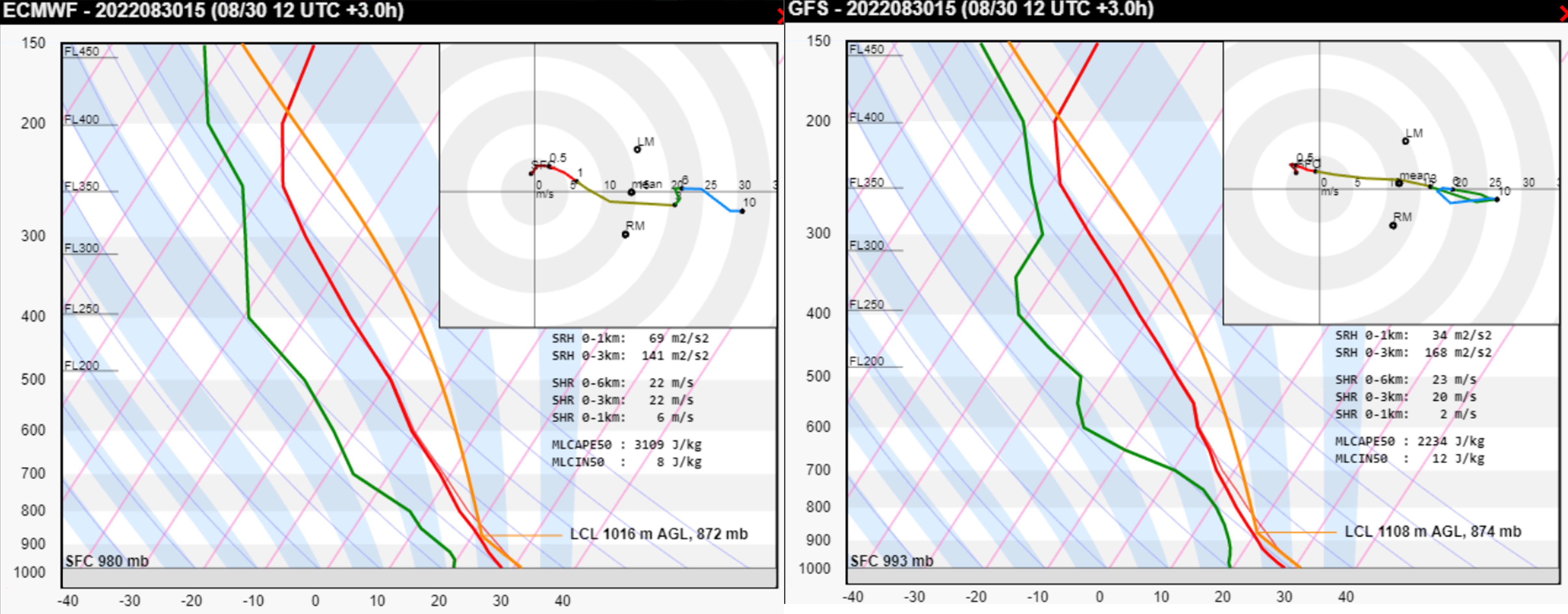
The supercell moved into the environment that has been found to be very conducive to severe weather, featuring high CAPE and strong vertical wind shear. Considering the model-simulated Skew-T and the surface observations from the area (temperature of 29, dewpoint of 23°C, and 5 m/s SSE wind), very large hail production was supported by:
High values of CAPE (MLCAPE ≈ 4000 J/kg) with large amounts of CAPE found in the temperature zone < -10°C
Vertical wind shear supportive of supercells. Very large hail occurs almost exclusively with this type of convection. Furthermore, strong shear resulted in a strong inflow into the storm. Based on the simulated hodograph, observed surface wind and observed storm motion, the surface inflow into the storm was almost 20 m/s. Strong inflow supports wide updrafts and wide updrafts lead to long hail embryo residence times in the favorable growth zone.
Unidirectional vertical wind shear (i.e. straight hodograph). Straight hodographs have been found to be more conducive to large hail growth than curved hodographs.
Both low-level shear and storm-relative helicity were quite weak in this case. Unlike for tornadoes, high values of these parameters are not necessary for very large or even giant hail.
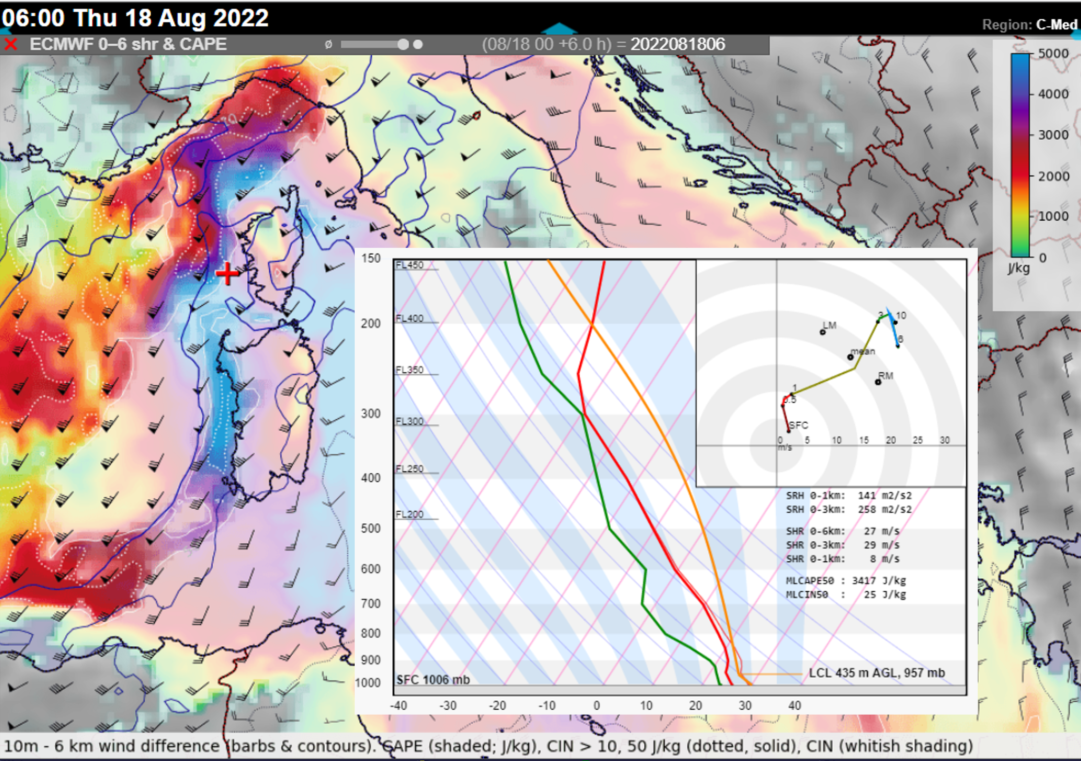
ICON-EU forecast of CAPE, 0-6 km bulk shear at 15 UTC with the model Skew-T and hodograph for the location represented by the red cross. The red star within the hodograph marks the observed surface wind and the blue star the observed storm motion. The black arrow is the surface storm-relative wind (i.e. inflow at that level).ECMWF and GFS forecast soundings for 15 UTC. Note the underestimation of surface dewpoint.
Supercell also profited from being the only storm around with no disruption to its inflow and updraft. Its deviant motion to the right was also more pronounced than anticipated by the Bunker’s ID method, suggesting the presence of a strong mesocyclone.
Was it possible to make a confident forecast of the storm producing hail reaching 10 cm? Such a forecast would be useful, as 10+ cm hailstones have a higher probability of causing both damage and injuries compared to 5+ cm hailstones. However, hail diameter doesn’t linearly increase with increasing CAPE and shear. For example, increasing CAPE may even limit the large hail production beyond some point. There are likely other factors that influence the trajectory of hail embryos through the updraft and their residence time in a zone of abundant super-cooled water droplets. Some of these are covered in a lecture by Matthew Kumjian. Testing these factors against a large sample of very large or giant hail cases will perhaps bring us even closer to confident forecasts of such devastating hailstorms.
In conclusion, the combination of very favorable large-scale conditions for hail with isolated convective initiation resulted in a perfect scenario for a damaging hailstorm. Such knowledge provided a good chance to correctly nowcast the event once the storm entered a supercell stage.
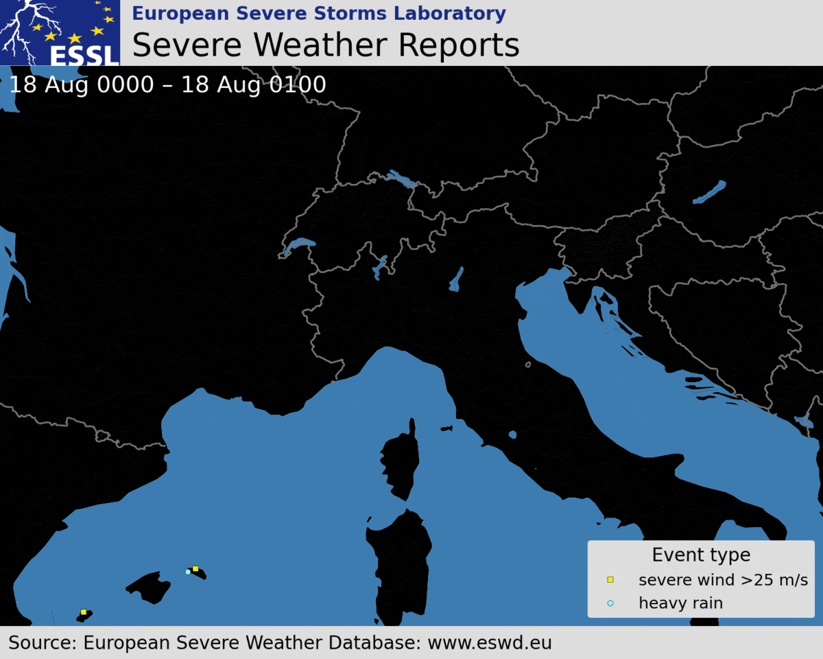
On 18 August, severe storms occurred in a swath from Menorca through Corsica, northern Italy, Slovenia, Austria, and southern Czechia. The event featured giant hail up to 11 cm in diameter and extremely severe wind gusts up to 62.2 m/s. In total, 12 people died and 106 people were injured by wind and hail. All fatalities, and most of the injuries, were caused by a long-lived convective system that produced a swath of severe to extremely severe wind gusts. The windstorm event can easily be classified as a derecho, a particularly long-lived and severe convective windstorm as the official criteria for a derecho were clearly met: its damage path exceeded 1000 km in length and wind gusts > 32 m/s were measured in Corsica, Italy, and Austria along the path of the storm.
Temporal evolution of ESWD reports for the event between 00 and 24 UTC.
This article describes in more detail the evolution of the event and its relation to the environment.
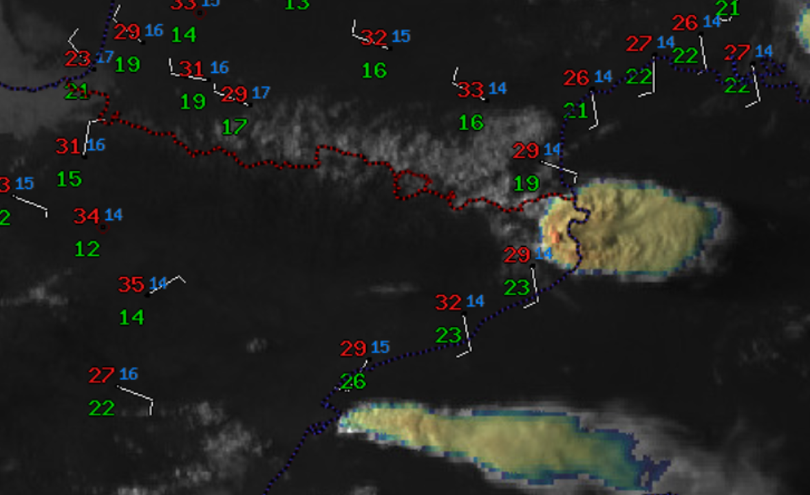
Temporal evolution of the derecho The first severe wind gust report was observed at 06:15 UTC in western Corsica. The last severe wind gust report was reported at 17:45 UTC from Czechia. Severe weather reports indicate that the derecho lasted at least 11 hours and 30 minutes. However, it is almost certain that the severe wind gusts occurred already sooner than 06:15 UTC. The severe wind gusts probably occurred as soon as 05:30 UTC, when the bow echo began to form. This means that the severe wind production in the storm lasted likely for more than 12 hours.
17 August
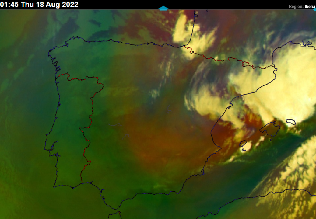
21:00 – 00:00 UTC: Storms initiated over the Balearic Sea. One of the storms became a right-moving supercell and intensified.
18 August
00:00 – 03:00 UTC: The right-moving severe storm grew in size and impacted Menorca. Heavy rainfall and severe wind gusts were reported. Further storms formed to the north.
Airmass RGB showing a severe storm over Menorca and a pronounced trough over western Spain and the Balearic Sea. Courtesy: EUMETSAT.
03:00 – 05:00 UTC: The storms continued to grow upscale and became a squall line. In the same period, a supercell ahead of the main storm system impacted Lavagna and Sestri Levante in Liguria, Italy with wind-driven hail up to 5 cm in diameter. 22 people were injured in this event. Cars, roofs, and facades of houses were badly damaged by hail.
Wind-driven hail damage to the house facade in Sestri Levante, Italy. Photo by Gherardo Ghotti.
05:00 – 06:00 UTC: The squall line transitioned into a bow shape just ahead of reaching Corsica with an increase in lightning activity and rapid acceleration towards the island’s western coastline.
06:00 – 07:00 UTC: The bow echo passed Corsica with extremely severe wind gusts up to 62.2 m/s in Marignana, a station located on a hill. Two other stations in Northwest Corsica measured wind gusts above 50 m/s. 4 people died and 10 were injured in this time frame. Severe winds capsized boats or blew the boats against the rocks and beaches. Damage to the roofs and power lines was reported. The updrafts of the storm, as well as lightning activity, weakened as the bow crossed the island.
07:00 – 08:00 UTC: The bow echo passed the northwestern part of Corsica and continued over the sea. 1 person died in this part of Corsica and wind gusts reached up to 34.4 m/s. Updrafts increased in intensity again as the bow entered the warm sea, as indicated by an uptick in lightning activity.
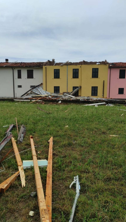
08:00 – 09:00 UTC: The bow echo impacted the western Italian coastline of southern Liguria and Tuscany with extremely severe wind gusts up to 38 m/s, causing widespread wind damage to trees and roofs. Some roofs were completely destroyed or blown away. 2 people died and 45 were injured. Lightning activity weakened and also the wind damage became more isolated as the storm passed the Apennines.
Roof damage in Ortonovo, Liguria, Italy. Photo byCittà Della Spezia.
09:00 – 10:00 UTC: Lightning activity of the storm increased and new updrafts developed over the lowlands behind the Apennines.
10:00 – 11:00 UTC: The storm system moved over the Veneto and Emilia-Romagna regions of Italy. Severe wind gusts reached up to 38 m/s and 9 people were injured.
11:00 – 12:00 UTC: The lightning activity decreased again as the storms reached the border between Italy and Slovenia. 2 injuries were reported in this period.
12:00 – 13:00 UTC: The system produced severe wind gusts over Slovenia and moved over southern Austria, where the storms intensified again. At the same time, a severe storm over Menorca produced very large hail up to 7 cm in diameter.
13:00 – 14:00 UTC: The system produced wind gusts up to 38.6 m/s in south-central Austria, mainly in Styria and Carinthia. 2 people died and 13 were injured in Mettersdorf. High voltage power lines were brought down by the winds. Storms were now traveling north.
14:00 – 15:00 UTC: The convective system continued producing severe winds over Austria with a maximum gust of 34.4 m/s as it traveled north. 3 further fatalities occurred in Styria as trees fell on hikers trying to protect themselves from the storm.
15:00 – 17:00 UTC: The system started decaying shortly after 16 UTC over northern Austria. Still, it managed to produce severe wind gusts over south-central Czechia.
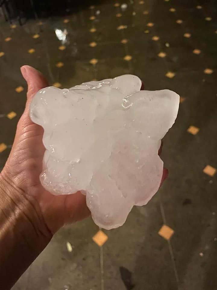
Further storm activity in the evening yielded very large to giant hail in Toscany and Marche regions, Italy. The largest hail fell in Macerata Feltria, measuring 11 cm across and injuring 1 person. Giant hail damaged cars, roofs, and solar panels.
Giant hail with size estimated at 11 cm across. Photo by Irene Gaggia.
The environment of the storms and its relation to their evolution.
The first storms over the Balearic Sea developed in the forward flank of the trough, in the exit region of a cyclonically curved jet stream. These storms were already forming in an environment of 0-6 km bulk shear > 20 m/s and plentiful CAPE. The transformation into the bow echo occurred in an environment featuring MLCAPE > 3000 J/kg, which is extraordinarily high, and 0-3 km bulk shear > 25 m/s, conditions very favorable for intense convective windstorms.
The very high CAPE values developed due to the presence of abundant low-level moisture and steep mid-tropospheric lapse rates that had been advected from Sahara. Such pronounced overlap of CAPE and shear was present west of Corsica and between Corsica and the coastline of Tuscany. Further north and northeast, CAPE was lower, but bulk shear remained favorable for well-organised squall lines (> 15 m/s in 0-3 km layer) as far as central Austria.
ECMWF forecast of MLCAPE and 0-6 km bulk shear combined with a forecast Skew-T and hodograph for a gridpoint west of Corsica.
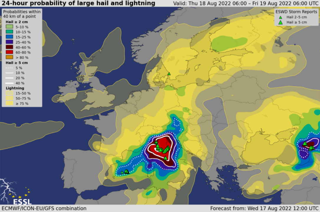
Besides the extremely severe wind gusts, the environment was very conducive for (very) large hail. ESSL’s experimental model-based forecasts AR-CHaMo predicted a large hail probability (within 40 km of a point) of over 60% in an area between Corsica, central and northeastern Italy in the 24-hour period between Thursday and Friday 06:00 UTC.
24-hour probability of large hail and lightning based on AR-CHaMo and the combination of 3 models.
While the presence of high CAPE and very strong shear helped the intense bow echo to develop, the crucial point was the upscale growth from the isolated storm to the squall line between Menorca and Corsica. We speculate that the development of the cold pool within the storm helped with the upscale growth. While the maritime boundary layer remained very moist, the presence of drier air and steep lapse rates above 900 hPa could have created strong downdrafts. Another factor may have been the mesoscale lift ahead of the progressing cold front that removed the CIN from the environment west of Corsica. The storm then tracked along the warm front towards Italy, where the further lift was provided by a warm air advection regime and a convergence zone. This lift also helped to remove the CIN from the environment. South of the warm front, CIN values were again very high, preventing convective initiation at this stage. Note that along the coast of Tuscany, vertical wind profiles would support intense tornadic supercells, but the organization of convection into a large-scale bow-echo lowered the threat of tornadoes compared to the severe wind gusts.
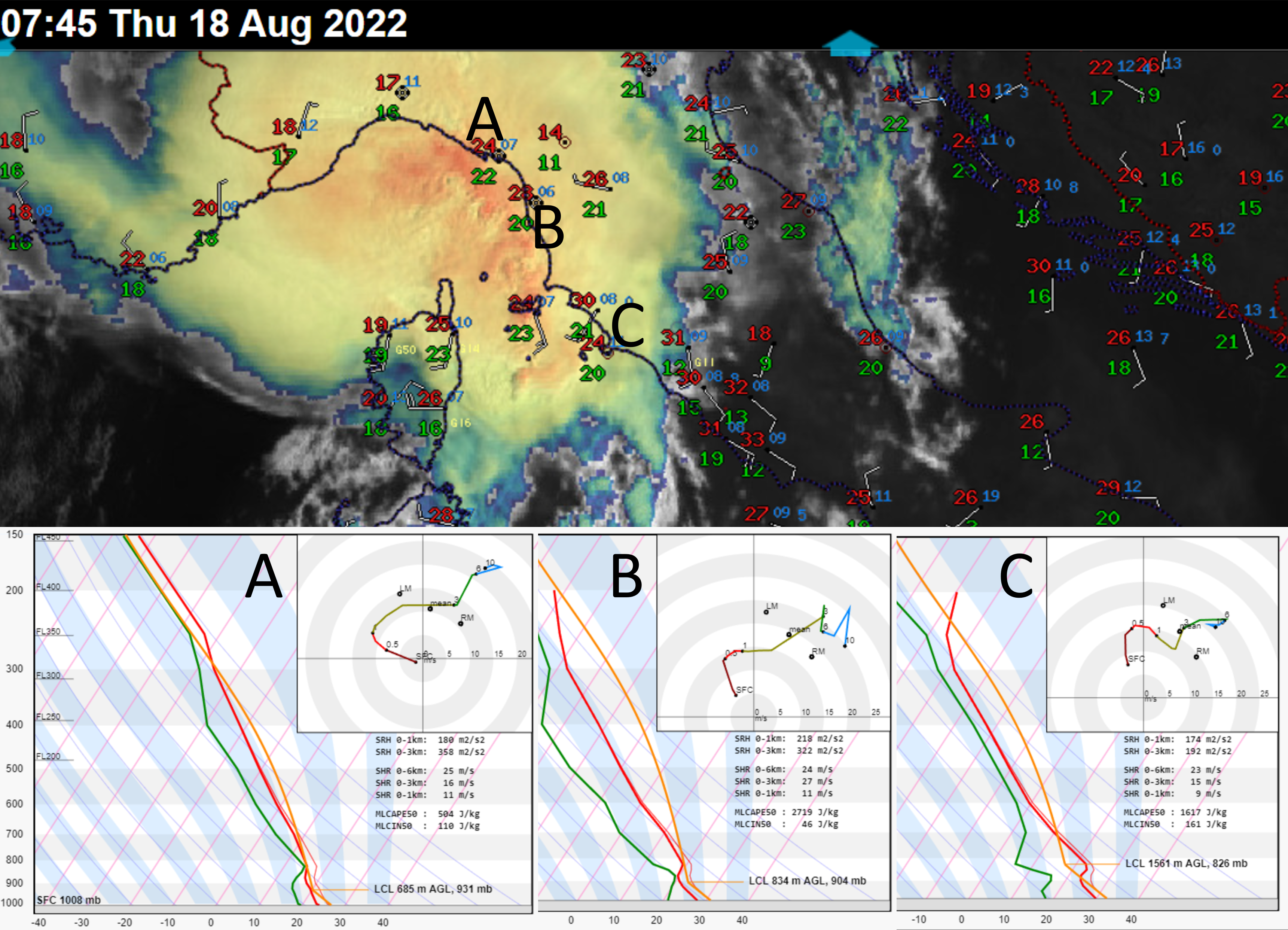
Sandwich imagery of the storm about to impact Italy at 07:45 UTC, combined with surface observations at 07:00 UTC. Positions of the three ICON-EU derived Skew-Ts are shown using the letters A, B and C. Note the temperature gradient along the warm front and the increase in CIN south of the front.
Looking at the surface observations, a cold pool was present during all stages of the derecho. The temperature of the cold pool of the storm remained constant throughout its evolution, between 20 and 21 degrees. The temperature difference between the cold pool and the surrounding environment increased as the system moved from the maritime areas further inland. Over western Corsica, the temperature decreased by 6 – 7 degrees when the gust front passed. Near the coastline of Tuscany, the temperature dropped only by 4 degrees. The temperature difference increased towards Austria and Slovenia with a drop of 9 to 13 degrees. This case shows that a strong cold pool is not necessary for a powerful convective windstorm.
The derecho went through several cycles of strengthening and weakening. By far the most impressive phase of strengthening occurred just west of Corsica as the squall line developed into a bow echo. The squall line was originally traveling towards the east. As the bow began to develop, the storm accelerated forward and its direction of movement turned more towards the north. The central part apex of the bow echo accelerated to an incredible speed of 40 – 50 m/s, compared to a mean wind of 17 m/s, which suggests the presence of a very strong rear inflow jet. The storm moved in the direction of the 0-3 km shear vector, i.e. in the direction of the strongest lift along the cold pool.
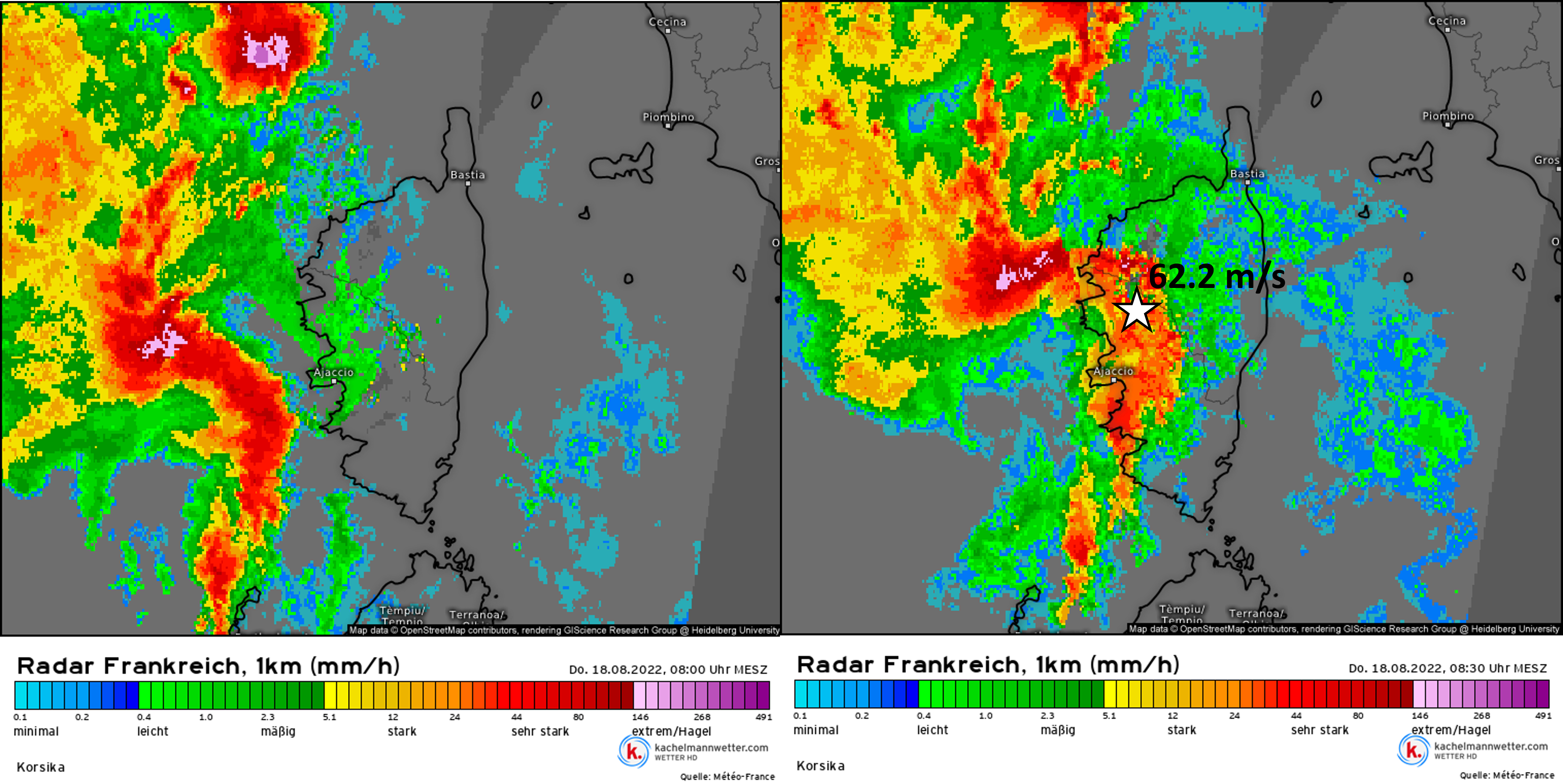
Bow-echo evolution over Corsica as shown by radar between 06:00 and 06:30 UTC. The location of the most severe wind gust is shown by the star. Source: kachelmannwetter.com, meteologix.com
During the course of its path, the storm weakened twice as it passed the high terrain of Corsica and the Apennines. Downslope winds and perhaps lower CAPE disrupted the generation of new updrafts, which can be seen in the satellite imagery and lightning detection data.
A sequence of sandwich satellite images showing a lack of overshooting top development as the system crossed Corsica.
The updrafts also weakened as the system moved through northeastern Italy. Over Slovenia, numerous severe wind gusts were observed well away from the heavy precipitation cores, suggesting a persistence of the outflow. Further intensification occurred as the outflow encountered the main Alpine ridge, over which new strong cells erupted. This was followed by an intensification of severe wind gusts, reaching over 32 m/s at several stations. At this time, the environment was still characterized by 0-3 km bulk shear exceeding 20 m/s.
Sandwich imagery from 13:30 UTC shows intensifying updrafts over the Alps. Yellow squares represent severe wind gust reports based on the ESWD.
The system finally died after moving over the area of weaker 0-3 km vertical wind shear, higher LFC, and marginal CAPE over northern Austria and southern Czechia.
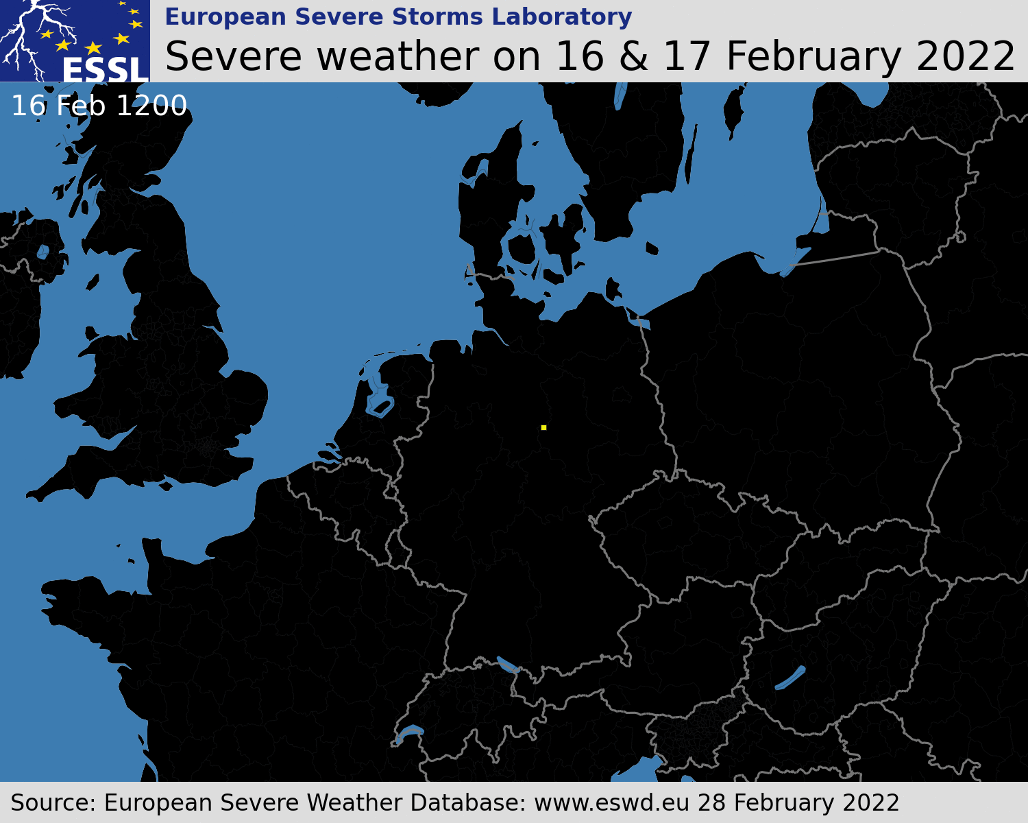
This short blog post provides an overview of severe weather associated with the recent windstorms and discusses why the windstorm of 16 – 17 February ended up as a prolific tornado producer.
Multiple severe windstorms affected Europe in the period of 16 – 21 February. 2814 reports of severe wind gusts were submitted to the ESWD in this period, the majority of them in the belt from the British Isles through northwestern France, BENELUX, Germany into Czechia, northern Austria, and Poland. The evolution of severe weather reports for the windstorm of 16 and 17 February is shown below
Temporal evolution of severe weather reports between 16 February 12 UTC and 17 February 12 UTC. Yellow squares represent severe wind gusts and red triangles tornadoes.
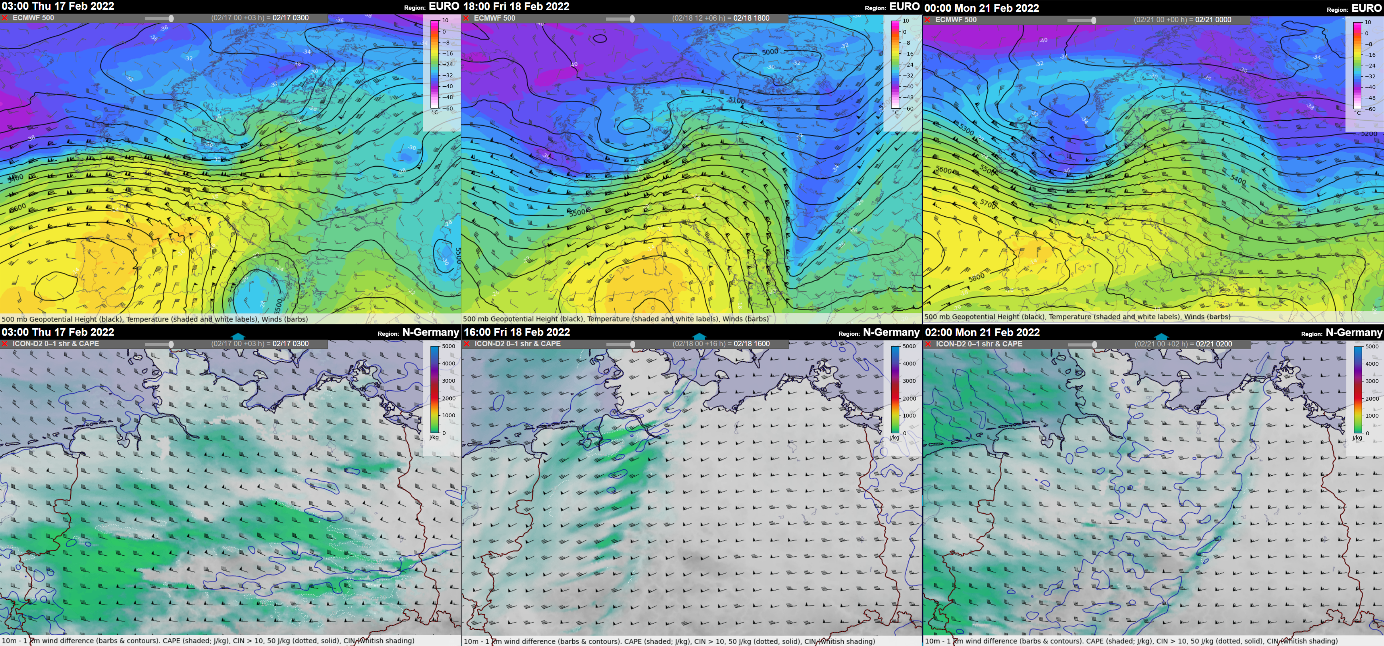
Each of the windstorms also involved a strongly-forced convective line that formed along the cold fronts ahead of the fast-moving short-wave troughs. In many areas, the passage of the convective line was accompanied by an increase in wind gusts severity. The environment featured marginal CAPE with a low Equilibrium level (suggesting low-topped storms) and strong vertical wind shear in the lower troposphere with 20 – 30 m/s of 0-1 km bulk shear. Very strong flow just above the ground explains the severity of wind gusts observed along the track of the storms.
500 hPa geopotential height, temperature, and wind (upper panel) and MLCAPE and 0-1 km bulk shear (lower panel) for 17 February, 18 February, and 21 February windstorms.
Due to the strong low-level shear, enhanced tornado threat accompanied the passage of all the windstorms. Between the night and morning hours of 17 February, a tornado outbreak occurred in a swath from northeastern Germany to south-central Poland, Malopolskie region. By 28 February, 22 tornadoes causing 2 fatalities and 5 injuries were reported in the ESWD, while further site surveys are ongoing by Skywarn Polska, and it is likely that the number of tornadoes will grow. 12 out of 22 tornadoes were strong and rated as IF2.
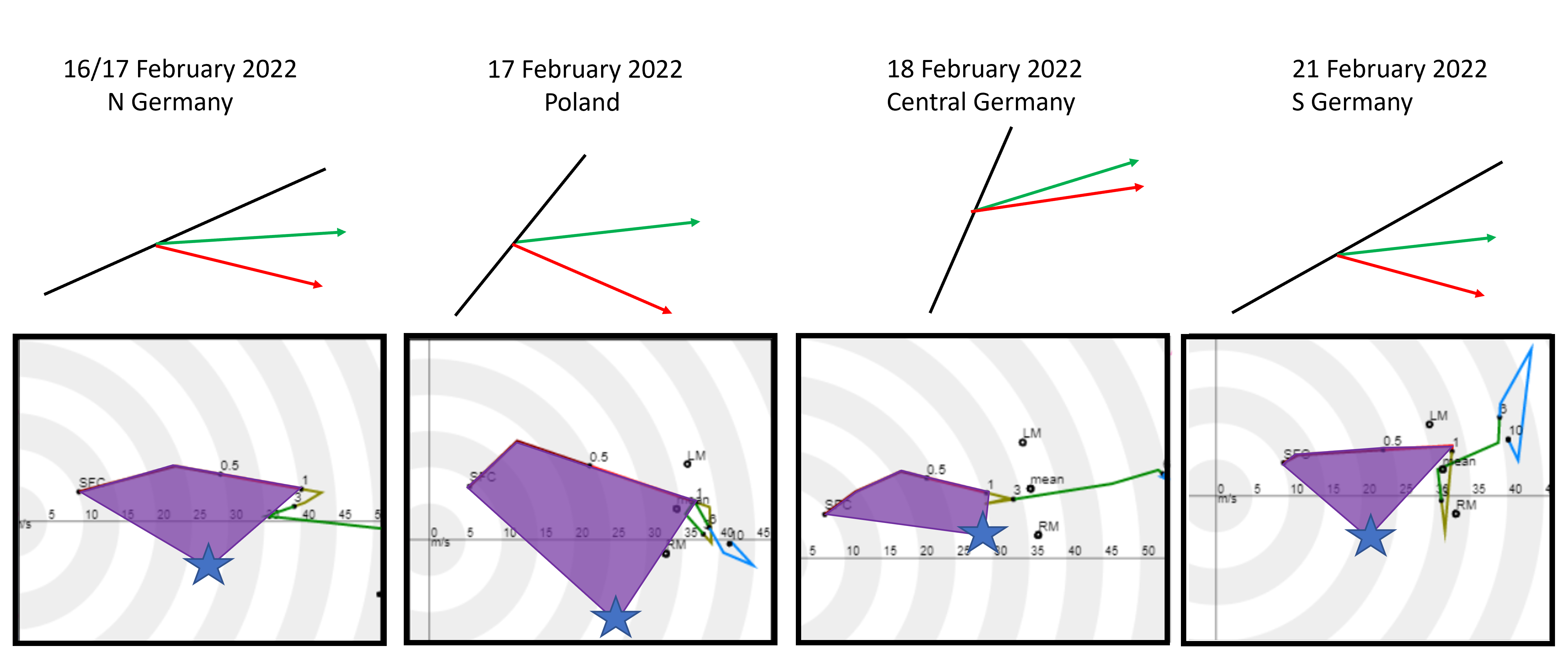
While the 17 February convective windstorm ended as a prolific tornado producer, the other two situations did not result in a single tornado despite a very strongly sheared environment. Overall, three windstorms occurred in this period: the 16 – 17 February windstorm (Dudley), the 18 February windstorm (Eunice), and the 20 – 21 February windstorm (Franklin). The 16 – 17 February and the 20 – 21 February windstorms featured well-organized convective systems with persistent bowing segments and inflow notches. The 18 February convective line was broken with no accompanying bowing segments.
The first difference among the three situations was in the orientation of the convective line, the direction of the mean wind (green arrow), and the direction of the movement of convective elements, such as bow-echoes or inflow-notches (red arrow). In all three situations, the convective elements within the line moved to the right of the mean wind. The largest angle between the mean wind and the orientation of the convective line was noted for the 17 February windstorm over Poland, suggesting the strongest lift on the leading edge of the convective line (perpendicular being the most “favorable” configuration). The individual convective elements also deviated most from the mean wind in this case.
Relationship of convective system orientation and motion of individual elements (such as bow-echoes) to the wind profile characteristics for different cases. Upper panel: Black lines denotes the orientation of the convective system, green arrows represent the mean wind, and red arrows the direction of motion of individual convective elements. Lower panel: Hodographs with 0-1 km SRH highlighted for observed storm motion of convective elements.
Hodographs based on the ICON-DE allow us to reconstruct the storm-relative helicity available to the convective elements in different situations. Considering the observed motion of the convective elements (marked in the hodograph by blue stars), the wind profile on 17 February over Poland had by far the most SRH. The inflow into the storm would be very strong (> 20 m/s) and contain almost purely streamwise vorticity (meaning aligned with the flow, making it “helical”). Strong inflow combined with large amounts of streamwise vorticity helped to create a favorable environment for the development of strong rotation in parts of the advancing convective system.
The reason for a higher amount of helicity was a stronger southerly component of the flow compared to the other situations. This is evident both from the hodographs and the surface station measurements. As the convective line crossed Central Europe between 16 and 17 February, 10 m wind over northern Germany had a smaller southerly component than over central Poland.
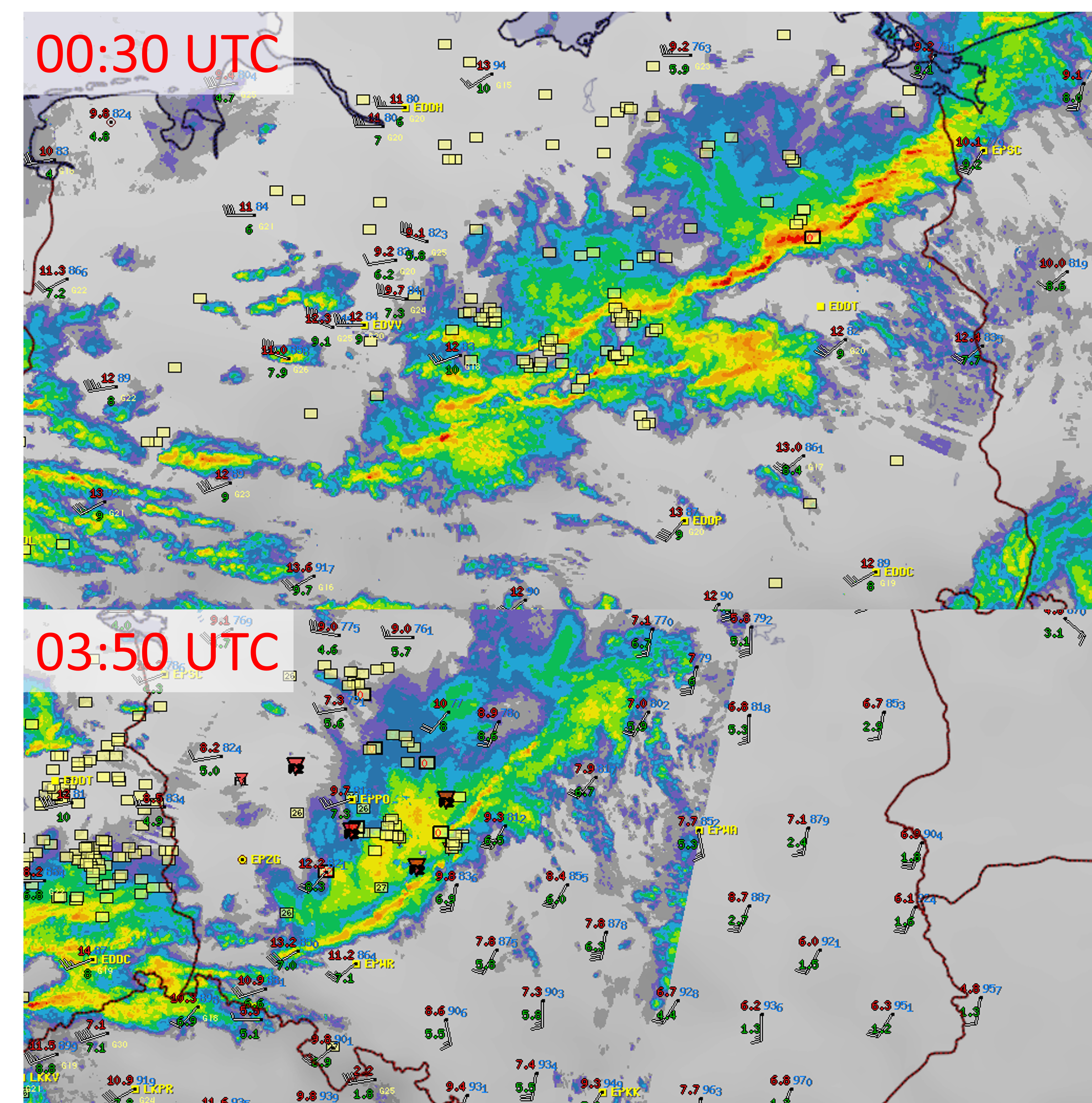
EUCom radar composite combined with surface station data (temperature and dew point shown in red and green color respectively) and ESWD reports (red triangles correspond to tornadoes and yellow squares to severe wind gusts).
The amount of helicity in the near-surface inflow seems to be the main difference between the tornado-producing convective windstorm over Poland on 17 February and the other windstorms. 17 February also had the most abundant low-level moisture content (and the highest CAPE values) as well as the line broken into many different convective elements (bow-echoes and inflow notches). Compared to the Kyrill tornado outbreak on 18 January 2007, cold pools were weaker on 17 February 2022.