
On 18 August, severe storms occurred in a swath from Menorca through Corsica, northern Italy, Slovenia, Austria, and southern Czechia. The event featured giant hail up to 11 cm in diameter and extremely severe wind gusts up to 62.2 m/s. In total, 12 people died and 106 people were injured by wind and hail. All fatalities, and most of the injuries, were caused by a long-lived convective system that produced a swath of severe to extremely severe wind gusts. The windstorm event can easily be classified as a derecho, a particularly long-lived and severe convective windstorm as the official criteria for a derecho were clearly met: its damage path exceeded 1000 km in length and wind gusts > 32 m/s were measured in Corsica, Italy, and Austria along the path of the storm.
This article describes in more detail the evolution of the event and its relation to the environment.
Temporal evolution of the derecho
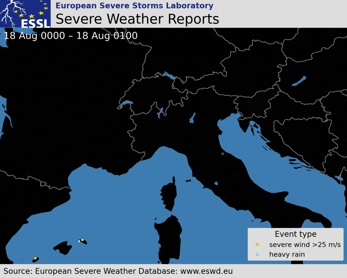
The first severe wind gust report was observed at 06:15 UTC in western Corsica. The last severe wind gust report was reported at 17:45 UTC from Czechia. Severe weather reports indicate that the derecho lasted at least 11 hours and 30 minutes. However, it is almost certain that the severe wind gusts occurred already sooner than 06:15 UTC. The severe wind gusts probably occurred as soon as 05:30 UTC, when the bow echo began to form. This means that the severe wind production in the storm lasted likely for more than 12 hours.
17 August
21:00 – 00:00 UTC: Storms initiated over the Balearic Sea. One of the storms became a right-moving supercell and intensified.
18 August
00:00 – 03:00 UTC: The right-moving severe storm grew in size and impacted Menorca. Heavy rainfall and severe wind gusts were reported. Further storms formed to the north.
and a pronounced trough over western Spain and the Balearic Sea.
Courtesy: EUMETSAT.
03:00 – 05:00 UTC: The storms continued to grow upscale and became a squall line. In the same period, a supercell ahead of the main storm system impacted Lavagna and Sestri Levante in Liguria, Italy with wind-driven hail up to 5 cm in diameter. 22 people were injured in this event. Cars, roofs, and facades of houses were badly damaged by hail.

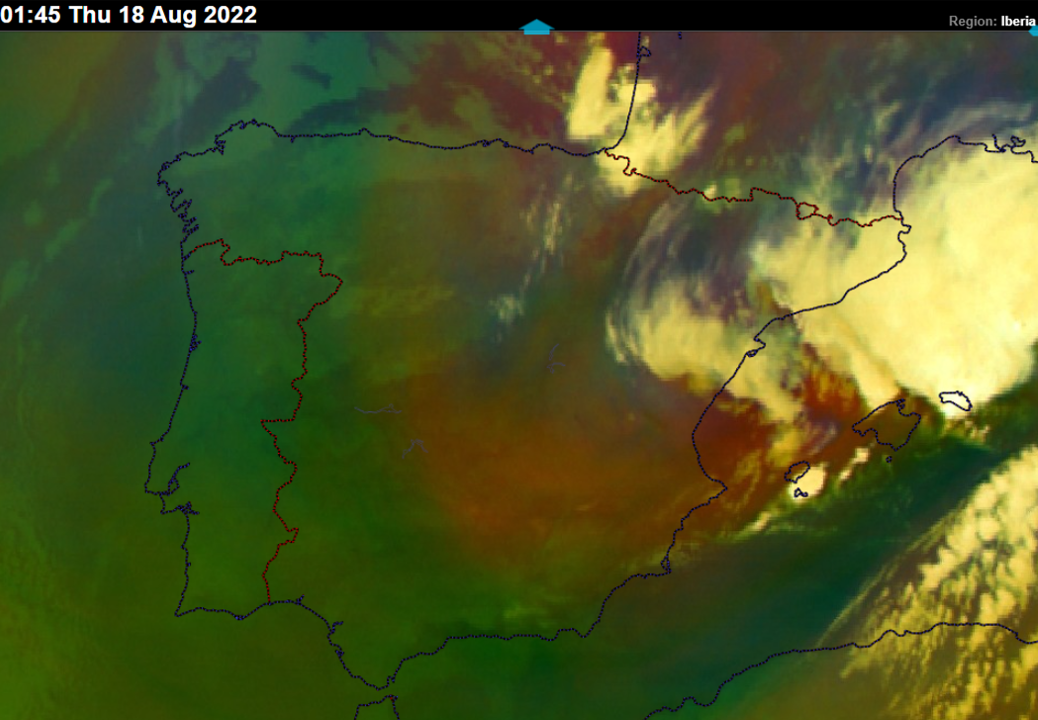
05:00 – 06:00 UTC: The squall line transitioned into a bow shape just ahead of reaching Corsica with an increase in lightning activity and rapid acceleration towards the island’s western coastline.
06:00 – 07:00 UTC: The bow echo passed Corsica with extremely severe wind gusts up to 62.2 m/s in Marignana, a station located on a hill. Two other stations in Northwest Corsica measured wind gusts above 50 m/s. 4 people died and 10 were injured in this time frame. Severe winds capsized boats or blew the boats against the rocks and beaches. Damage to the roofs and power lines was reported. The updrafts of the storm, as well as lightning activity, weakened as the bow crossed the island.
07:00 – 08:00 UTC: The bow echo passed the northwestern part of Corsica and continued over the sea. 1 person died in this part of Corsica and wind gusts reached up to 34.4 m/s. Updrafts increased in intensity again as the bow entered the warm sea, as indicated by an uptick in lightning activity.
08:00 – 09:00 UTC: The bow echo impacted the western Italian coastline of southern Liguria and Tuscany with extremely severe wind gusts up to 38 m/s, causing widespread wind damage to trees and roofs. Some roofs were completely destroyed or blown away. 2 people died and 45 were injured. Lightning activity weakened and also the wind damage became more isolated as the storm passed the Apennines.
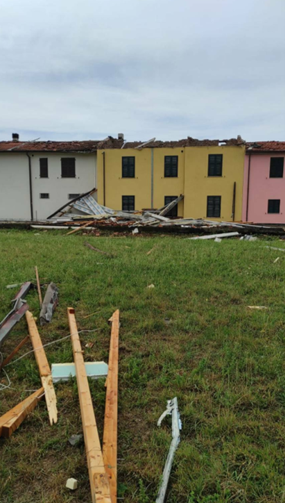
Photo by Città Della Spezia.
09:00 – 10:00 UTC: Lightning activity of the storm increased and new updrafts developed over the lowlands behind the Apennines.
10:00 – 11:00 UTC: The storm system moved over the Veneto and Emilia-Romagna regions of Italy. Severe wind gusts reached up to 38 m/s and 9 people were injured.
11:00 – 12:00 UTC: The lightning activity decreased again as the storms reached the border between Italy and Slovenia. 2 injuries were reported in this period.
12:00 – 13:00 UTC: The system produced severe wind gusts over Slovenia and moved over southern Austria, where the storms intensified again. At the same time, a severe storm over Menorca produced very large hail up to 7 cm in diameter.
13:00 – 14:00 UTC: The system produced wind gusts up to 38.6 m/s in south-central Austria, mainly in Styria and Carinthia. 2 people died and 13 were injured in Mettersdorf. High voltage power lines were brought down by the winds. Storms were now traveling north.
14:00 – 15:00 UTC: The convective system continued producing severe winds over Austria with a maximum gust of 34.4 m/s as it traveled north. 3 further fatalities occurred in Styria as trees fell on hikers trying to protect themselves from the storm.
15:00 – 17:00 UTC: The system started decaying shortly after 16 UTC over northern Austria. Still, it managed to produce severe wind gusts over south-central Czechia.
Further storm activity in the evening yielded very large to giant hail in Toscany and Marche regions, Italy. The largest hail fell in Macerata Feltria, measuring 11 cm across and injuring 1 person. Giant hail damaged cars, roofs, and solar panels.

The environment of the storms and its relation to their evolution.
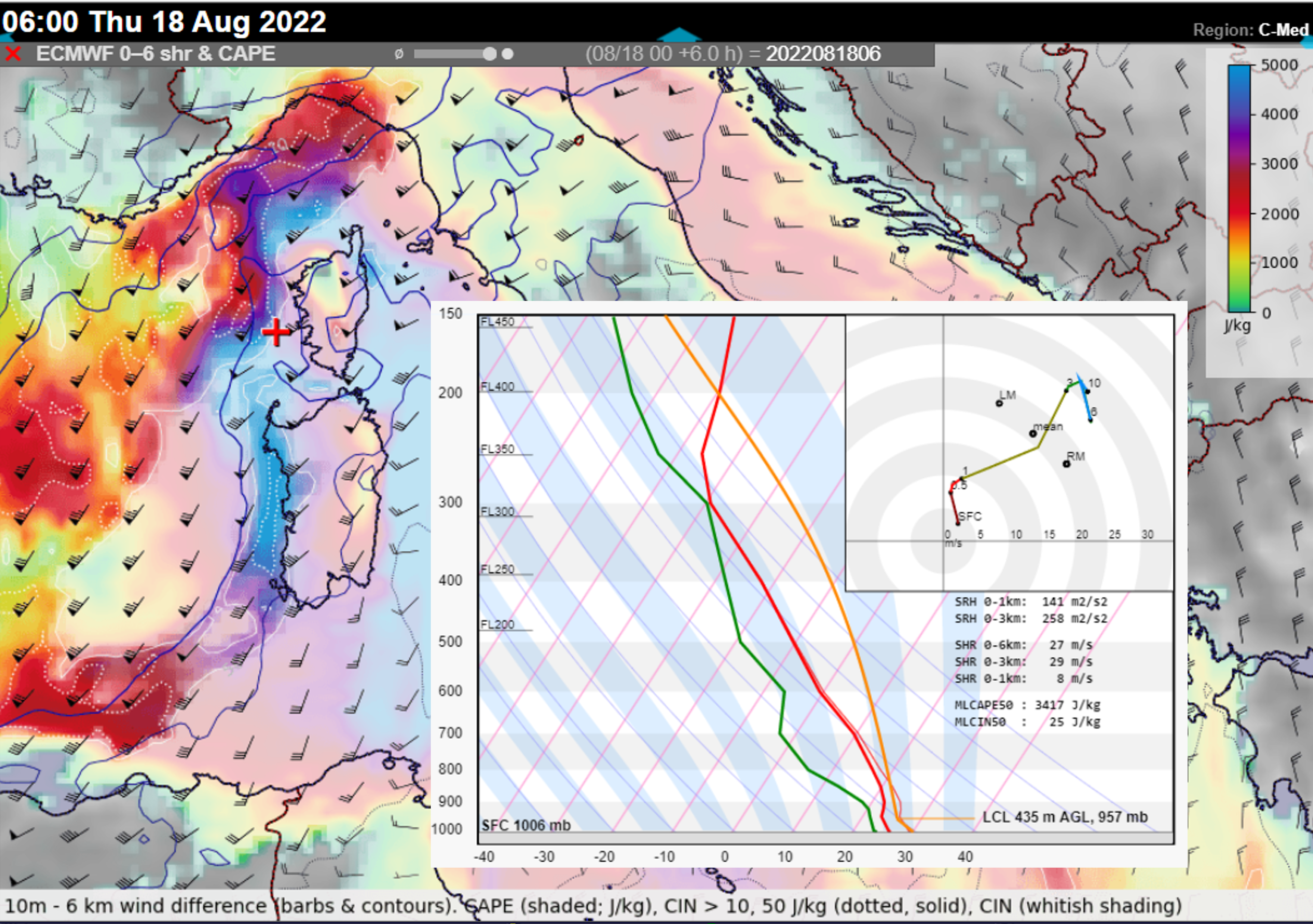
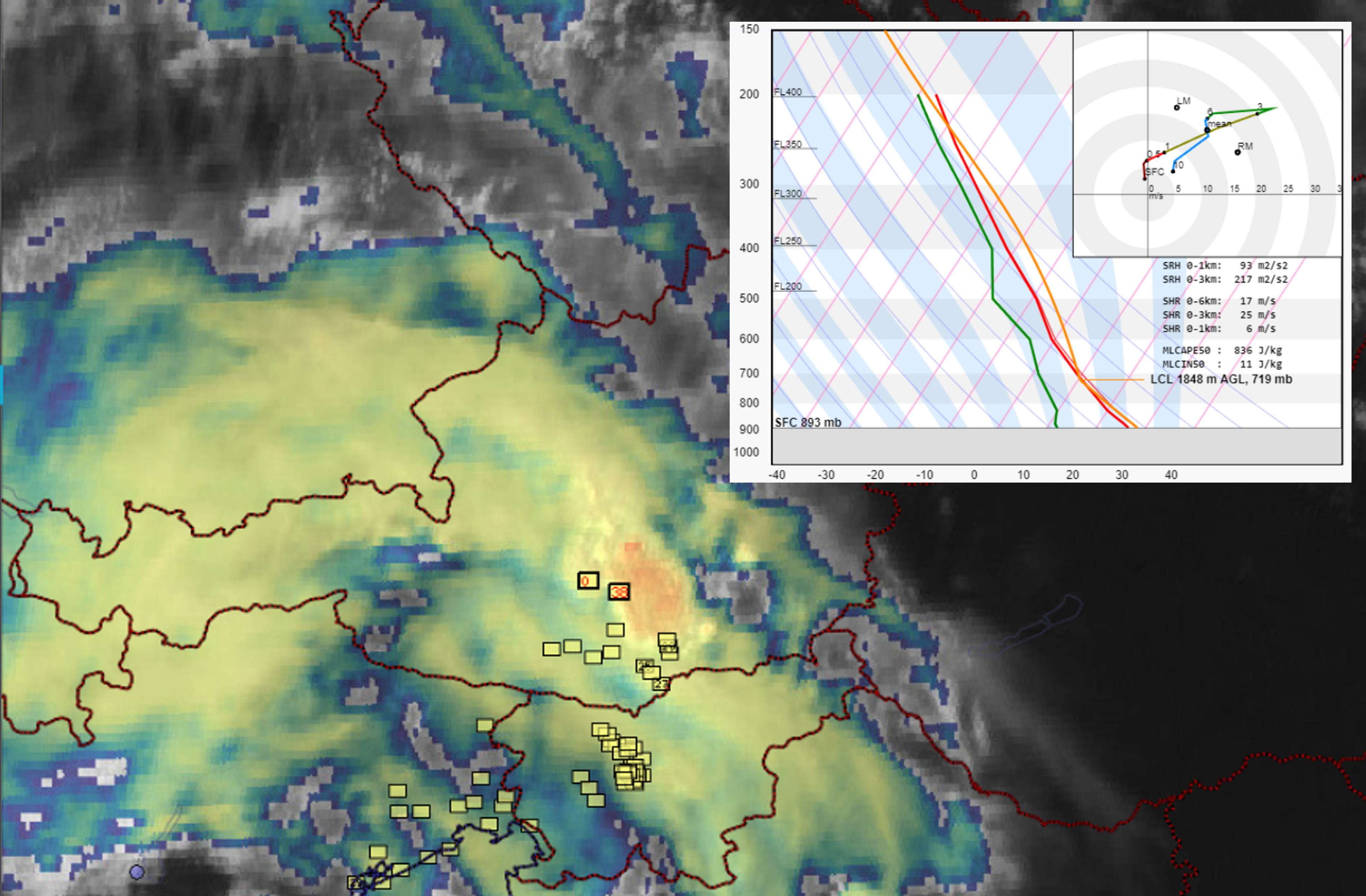
The first storms over the Balearic Sea developed in the forward flank of the trough, in the exit region of a cyclonically curved jet stream. These storms were already forming in an environment of 0-6 km bulk shear > 20 m/s and plentiful CAPE. The transformation into the bow echo occurred in an environment featuring MLCAPE > 3000 J/kg, which is extraordinarily high, and 0-3 km bulk shear > 25 m/s, conditions very favorable for intense convective windstorms.
The very high CAPE values developed due to the presence of abundant low-level moisture and steep mid-tropospheric lapse rates that had been advected from Sahara. Such pronounced overlap of CAPE and shear was present west of Corsica and between Corsica and the coastline of Tuscany. Further north and northeast, CAPE was lower, but bulk shear remained favorable for well-organised squall lines (> 15 m/s in 0-3 km layer) as far as central Austria.
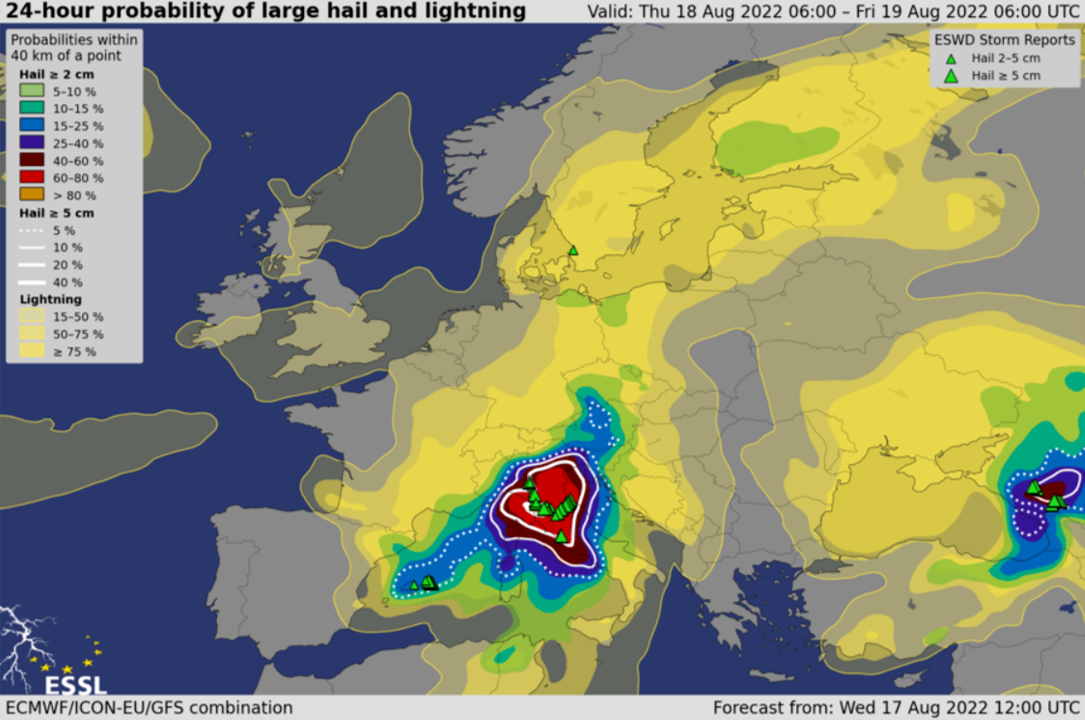
Besides the extremely severe wind gusts, the environment was very conducive for (very) large hail. ESSL’s experimental model-based forecasts AR-CHaMo predicted a large hail probability (within 40 km of a point) of over 60% in an area between Corsica, central and northeastern Italy in the 24-hour period between Thursday and Friday 06:00 UTC.
While the presence of high CAPE and very strong shear helped the intense bow echo to develop, the crucial point was the upscale growth from the isolated storm to the squall line between Menorca and Corsica. We speculate that the development of the cold pool within the storm helped with the upscale growth. While the maritime boundary layer remained very moist, the presence of drier air and steep lapse rates above 900 hPa could have created strong downdrafts. Another factor may have been the mesoscale lift ahead of the progressing cold front that removed the CIN from the environment west of Corsica. The storm then tracked along the warm front towards Italy, where the further lift was provided by a warm air advection regime and a convergence zone. This lift also helped to remove the CIN from the environment. South of the warm front, CIN values were again very high, preventing convective initiation at this stage. Note that along the coast of Tuscany, vertical wind profiles would support intense tornadic supercells, but the organization of convection into a large-scale bow-echo lowered the threat of tornadoes compared to the severe wind gusts.
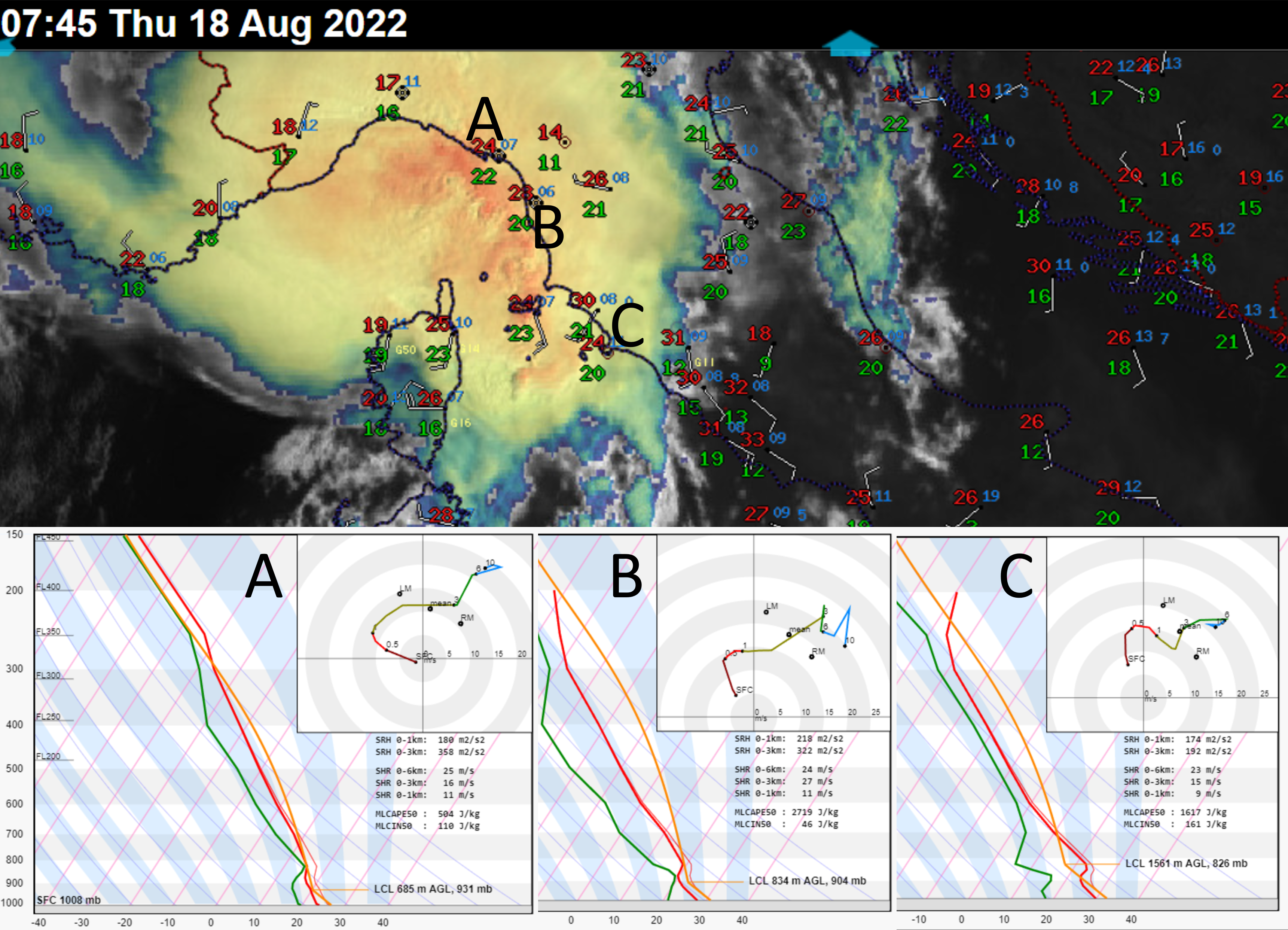
observations at 07:00 UTC. Positions of the three ICON-EU derived
Skew-Ts are shown using the letters A, B and C. Note the temperature gradient
along the warm front and the increase in CIN south of the front.
Looking at the surface observations, a cold pool was present during all stages of the derecho. The temperature of the cold pool of the storm remained constant throughout its evolution, between 20 and 21 degrees. The temperature difference between the cold pool and the surrounding environment increased as the system moved from the maritime areas further inland. Over western Corsica, the temperature decreased by 6 – 7 degrees when the gust front passed. Near the coastline of Tuscany, the temperature dropped only by 4 degrees. The temperature difference increased towards Austria and Slovenia with a drop of 9 to 13 degrees. This case shows that a strong cold pool is not necessary for a powerful convective windstorm.
The derecho went through several cycles of strengthening and weakening. By far the most impressive phase of strengthening occurred just west of Corsica as the squall line developed into a bow echo. The squall line was originally traveling towards the east. As the bow began to develop, the storm accelerated forward and its direction of movement turned more towards the north. The central part apex of the bow echo accelerated to an incredible speed of 40 – 50 m/s, compared to a mean wind of 17 m/s, which suggests the presence of a very strong rear inflow jet. The storm moved in the direction of the 0-3 km shear vector, i.e. in the direction of the strongest lift along the cold pool.
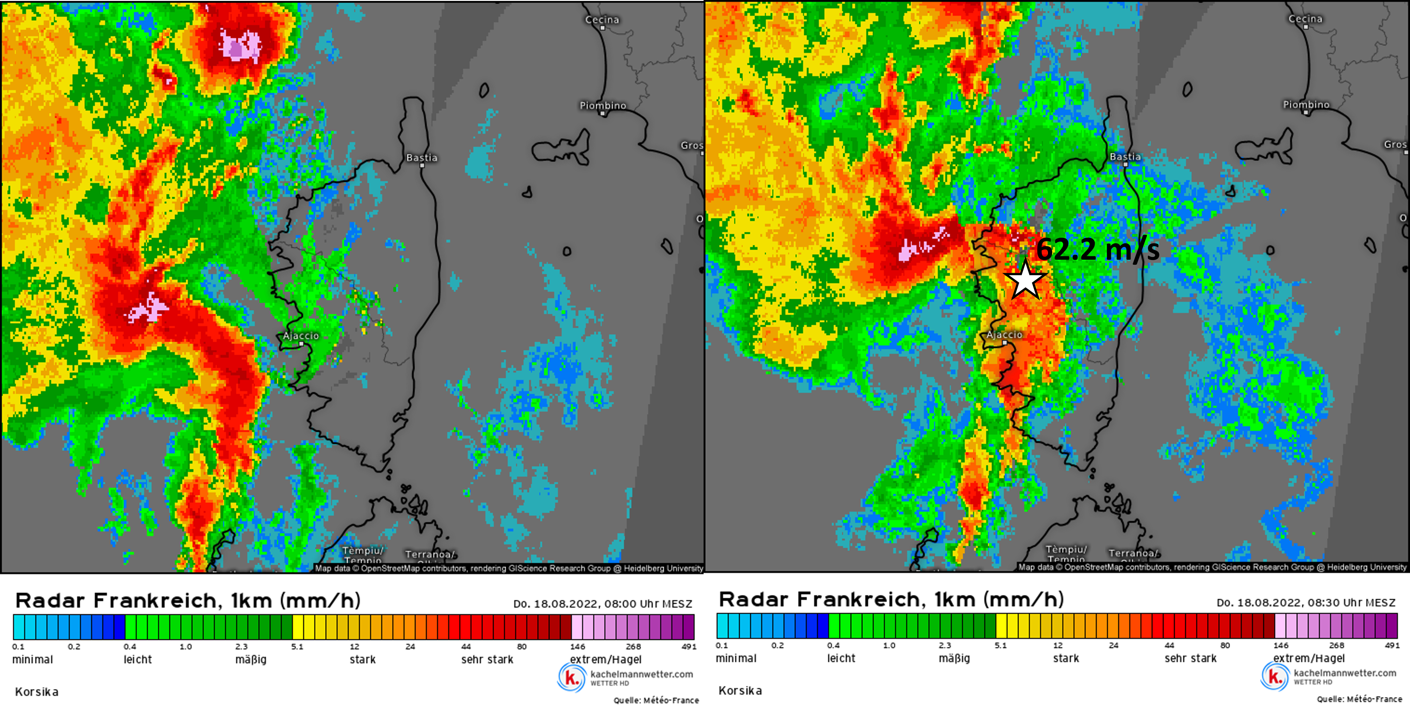
The location of the most severe wind gust is shown by the star.
Source: kachelmannwetter.com, meteologix.com
During the course of its path, the storm weakened twice as it passed the high terrain of Corsica and the Apennines. Downslope winds and perhaps lower CAPE disrupted the generation of new updrafts, which can be seen in the satellite imagery and lightning detection data.
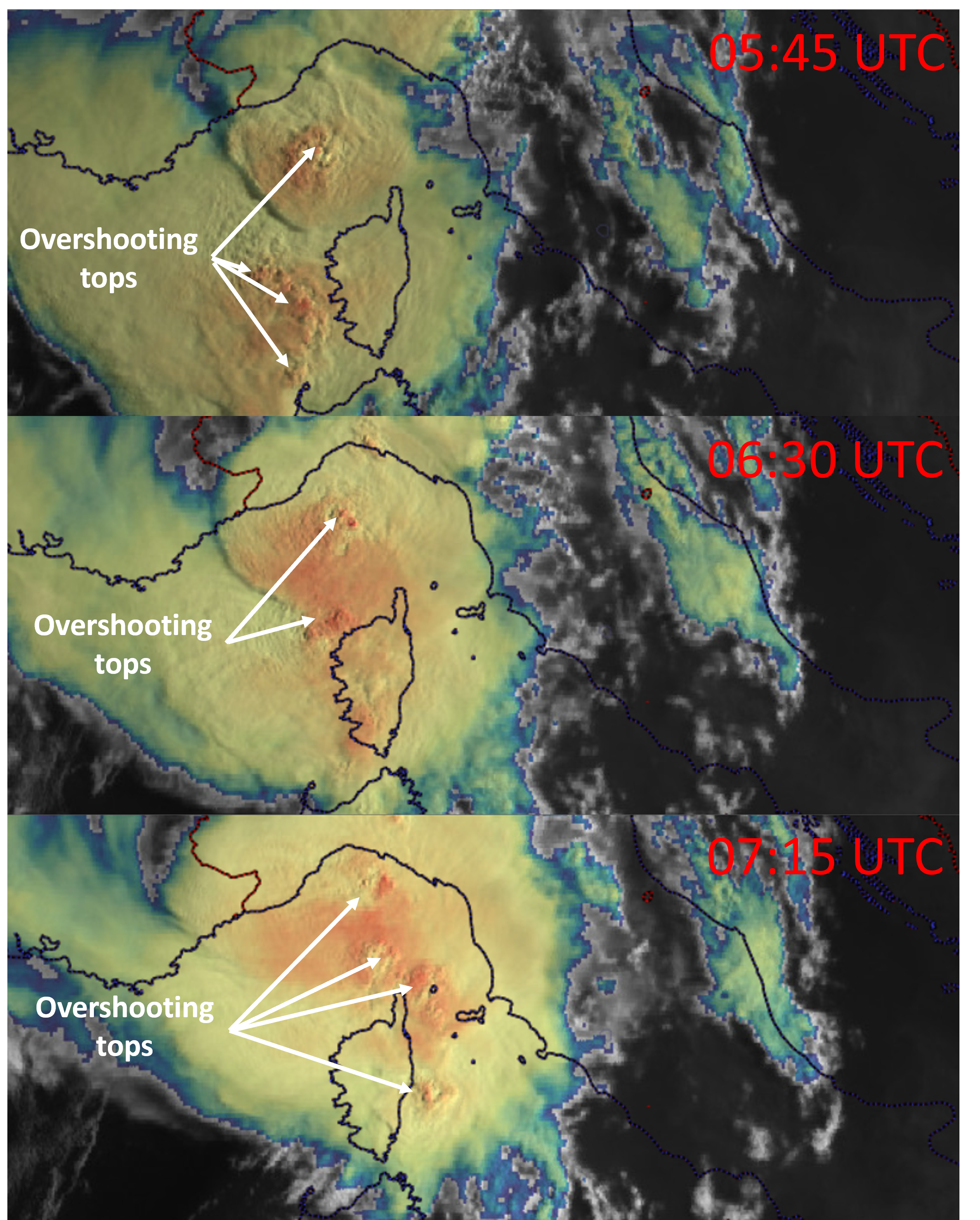
as the system crossed Corsica.
The updrafts also weakened as the system moved through northeastern Italy. Over Slovenia, numerous severe wind gusts were observed well away from the heavy precipitation cores, suggesting a persistence of the outflow. Further intensification occurred as the outflow encountered the main Alpine ridge, over which new strong cells erupted. This was followed by an intensification of severe wind gusts, reaching over 32 m/s at several stations. At this time, the environment was still characterized by 0-3 km bulk shear exceeding 20 m/s.
Yellow squares represent severe wind gust reports based on the ESWD.
The system finally died after moving over the area of weaker 0-3 km vertical wind shear, higher LFC, and marginal CAPE over northern Austria and southern Czechia.
