Monika Feldmann is the awardee of the EMS YSCA. The award was presented to her at the occasion of the ECSS2025 conference dinner in Utrecht, the Netherlands, by ESSL officials on behalf of the European Meteorological Society.
From right to left: Monika Feldmann, University of Bern – awardee of the EMS YSCA; Bogdan Antonescu, ESSL; Alois Holzer, ESSL; Tanja Renko, ESSL; Michou Baart de la Faille, ESSL; Pieter Groenemeijer, ESSL. Photo credit: ESSL, Igor Laskowski.
The scientific programme for the European Conference on Severe Storms was published on 8 August. Corresponding emails were sent to the contributing authors and co-authors.
The submissions promise a high-quality and diverse scientific programme. 220 posters and 82 oral presentations were selected by the Scientific Programme Committee (SPC) chaired by Dr Kelly Lombardo. In many cases, the decision was not easy. The ESSL would like to thank all members of the SPC for their important voluntary work.
In addition to the presentations, a panel discussion on the various improvements and knock-on effects for nowcasting expected from MTG is scheduled for late Tuesday afternoon during the conference week.
On Wednesday, a panel discussion will be held to assess the rich legacy of Dr Chuck Doswell who passed away earlier this year.
Due to the slight delay in finalizing the programme, the deadline for the “Early Registration” fees has been postponed to 25 August at 12 UTC. More information on the registration process can be found here.
The European Severe Weather Database (ESWD) will receive an update of its user interface. The relaunch is scheduled for 27 August 2025.
All active users have been informed accordingly. More information on the new capabilities we will publish with the next ESSL Newsletter due end of September.
Upon multiple request, the abstract submission deadline has been postponed to June 15, 2025.
15 June is the final deadline, there will be no further extensions.
We cordially invite you to submit a contribution for the 12th European Conference on Severe Storms, which will take place in Utrecht, the Netherlands, from 17 to 21 November 2025.
Please note that for travel support applications, the deadline remains 6 June 2025.
A direct link to the abstract submission tool you can find here.
The ECSS Scientific Program Committee, ESSL and its partners are preparing a high-level scientific program for you and looking forward to your participation. Please submit your contribution in time.
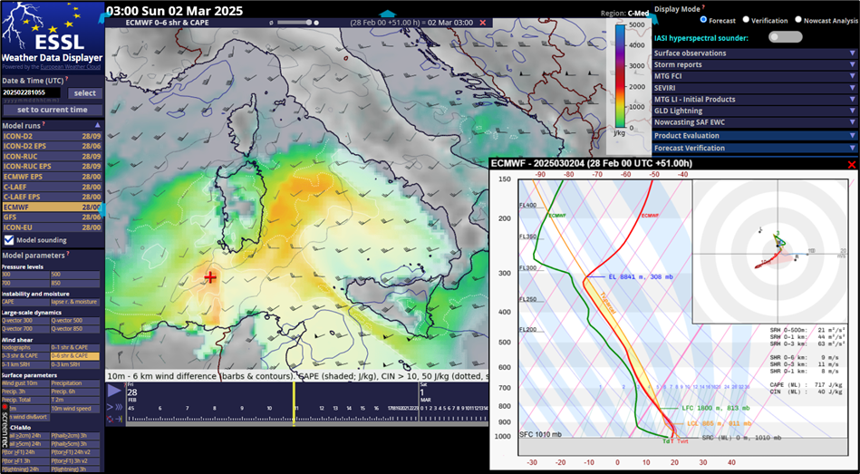
The ESSL Weather Data Displayer has been a success story.
Since 2012, hundreds of forecasters have found it useful, especially for, but
not limited to, forecasting severe convective storms. The Displayer has been used
at numerous courses and testbeds and had been developed based on feedback
received from forecasters from across Europe and from overseas. The main
developer of the Displayer is ESSL Director Dr. Pieter Groenemeijer.
In the past years, ESSL was asked by national and regional
weather services, international organizations, universities and research
institutes to make the Displayer available to them. Starting in 2025, the
Displayer is ready to be licenced to users. Which data sets are included within
the Displayer depends on the licence model and on the pre-existing access
rights of the user to restricted third party data, for example certain products
from ECMWF and EUMETSAT.
Screenshot of the ESSL Weather Data Displayer on 28 February 2025. ECMWF CAPE and 0-6 km shear chosen for C-Med domain and forecast time step 2 March 2025 03:00 UTC. Model sounding tool switched on for location south of Sardegna.
The ESSL and KNMI invite you to the 12th European Conference on Severe Storms to be held 17-21 November 2025 in Utrecht in the Netherlands.
The Second Announcement and Call for Papers (PDF) is available here.
The ECSS2025 webpage including registration and abstract submission pages is linked here.
Travel support for students and early career scientists will be available from both ESSL and our co-sponsor EMS (via their Young Scientist Conference Award). In addition, a new and attractive student registration fee is introduced for 290 EUR only.
We have received the sad news of the passing away of Charles A. Doswell III, or Chuck, as most will know him. A Honorary Member of ESSL, Chuck has been an extraordinary supporter of the European Severe Storms community, right from the first edition of the conference series that became the ECSS conferences in Toulouse in 2000. Chuck Doswell was a researcher who worked at several employers including the National Severe Storms Laboratory in Norman, Oklahoma. He did not only have a strong interest in severe weather research, but also in it resulting in quantifiable, meaningful outcomes.
He had a particular talent for reducing the complexity of severe storm forecasting to its fundamentals (lift, moisture, and instability), for which he was awarded the Nikolai Dotzek Award in 2013. He always made sure that these basics were fully understood by his audience whenever he presented them in his own special style. Chuck actively supported everyone with a genuine interest in making progress in severe weather forecasting, including the founders of ESSL and the ESTOFEX project. ESSL is extremely thankful to have enjoyed his support from consulting us on the European Severe Weather Database to teaching at the ESSL Testbeds and courses. Now, we are confident that the instability has lifted him to a place where he is now enjoying his favorite red grapy moisture.
The ESSL team are sad to have received the news of the passing away of Prof Dr Robert Sausen.
Robert Sausen, Deputy Director of the DLR Institute for Atmospheric Physics, has been a crucial supporter of ESSL in the years after its founding. He served as the first Chair of the ESSL Advisory Council from 2008 until 2015, supporting ESSL in countless ways. In those days, his support of ESSL, being the legacy of Nikolai Dotzek, was crucial.
We are very grateful to him and wish his wife, family, friends, former colleagues, and others close to him strength to cope with this loss.
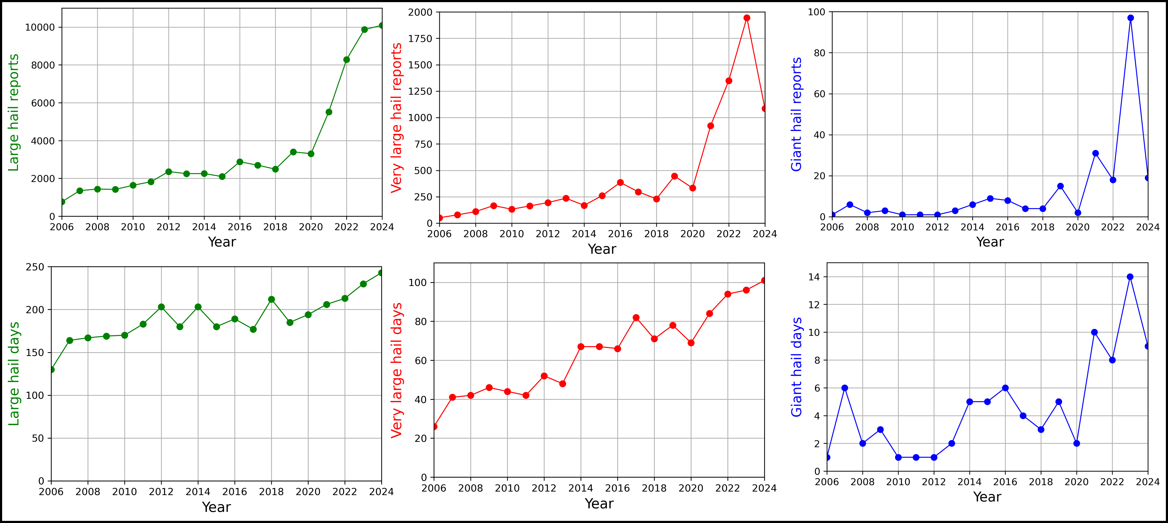
Compared to 2023, 2024 hasn’t featured record-breaking hailstorms or situations that matched the ferocity of 19 and 24 July 2023 or 26 August 2023. However, it was still a very active year, resulting in the most hail reports ever reported into the ESWD: 10 092, as well as days with large (≥ 2cm) and very large (≥ 5cm) hail days: 243 and 101 respectively. In terms of the sheer number of the most damaging hail events, 2024 pales in comparison with 2023 with a decrease in very large hail reports from 1946 to 1086 and giant hail (≥ 10 cm) reports from 97 to 19. These numbers represent the European Severe Weather Database state as of 04 January 2025.
Number of reports and days with large (2+ cm), very large (5+ cm), and giant (10+ cm) hail between 2006 and 2024 according to the ESWD.
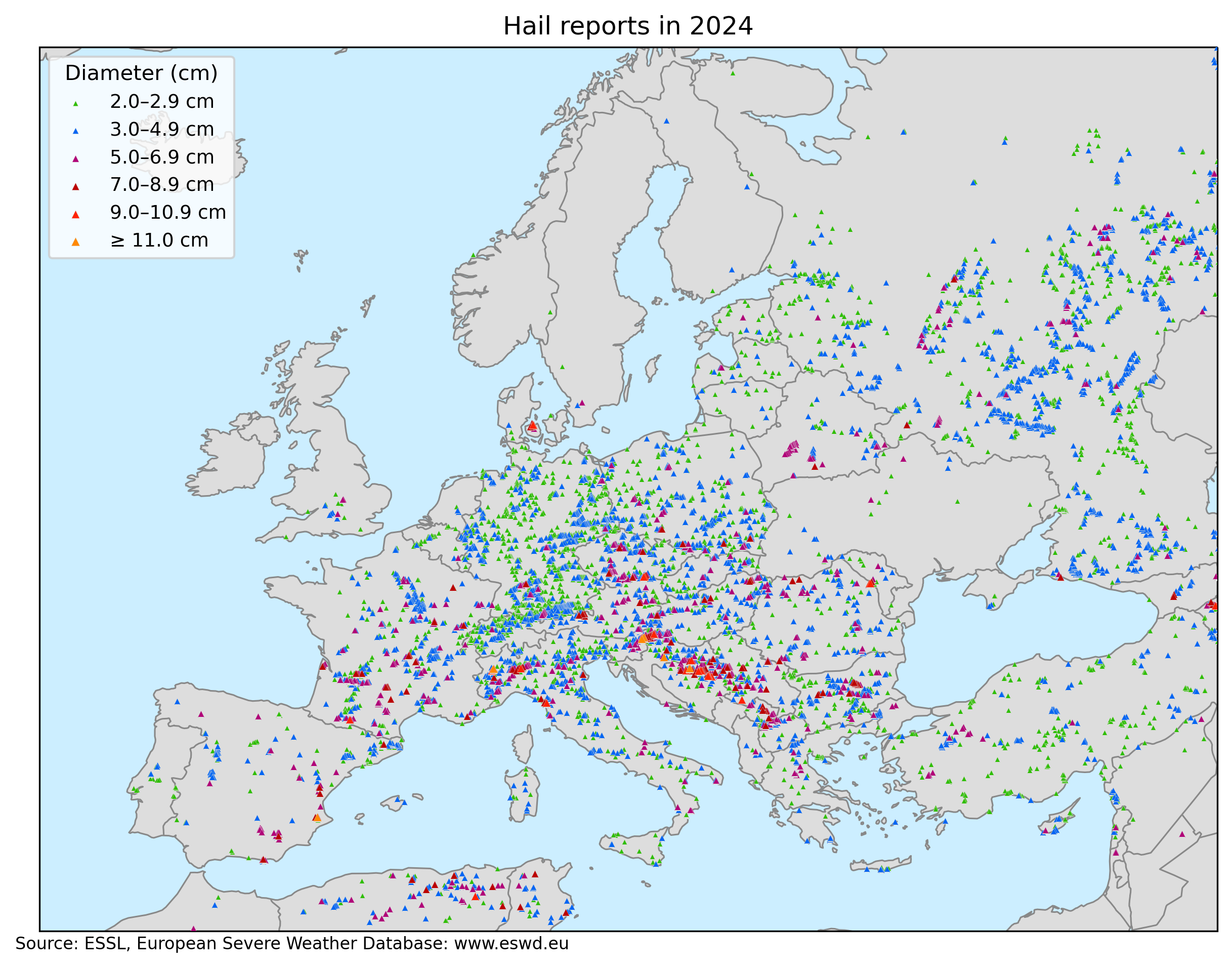
Different regions of Europe were affected by hailstorms this year. In June, southeastern Europe was especially active with multiple devastating and long-tracked hailstorms. This month was also by far the most active concerning large hail. The activity shifted further west and north towards July and August and the number of severe hailstorms dropped since mid-July with large parts of Europe experiencing drought.
Spatial distribution of large hail reports across Europe and surrounding territory in 2024.
ESSL would like to express deep gratitude to all the voluntary observer persons and networks, who have greatly helped with the severe weather data collection across Europe. Now let’s have a look at the individual major hail cases last year. The list is non-exhaustive. And before we move on,
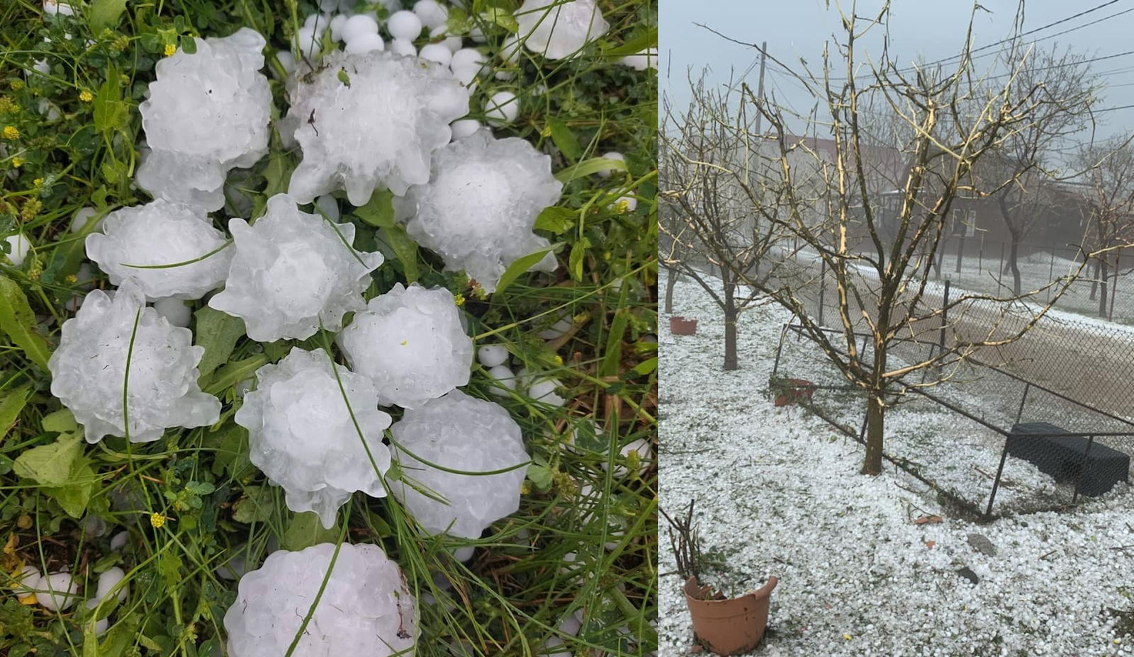
28 March: A curious event with hail up to 6.5 cm in diameter across the southern UK in a marginal CAPE environment.
3 June: A hailstorm cut a 137 km path across northern Bosnia, extreme eastern Croatia and western Serbia. Hail reached up to 7 cm in diameter with most damage reported as the storm transitioned to a bow echo with wind-driven hail damaging facades of houses, breaking windows, and destroying crops between Croatia and Serbia.
4 June: Numerous damaging hailstorms occurred in Romania, Bulgaria, Moldova, and Ukraine. Two events stood out from the rest. The first involved densely falling wind-driven hail in Săsarm, Romania, reaching up to 5 cm in diameter. The facades, windows, and roofs of the houses were seriously damaged. Vegetation also suffered with some of the trees partially debarked by falling hail. Further east, a hailstorm crossed from Romania to Moldova, producing the first giant hail report of the year in the village of Răducăneni with hail reaching 10 cm in diameter and causing significant damage.
Photos by Gabriel Melescanu and Muresan Bianca. Source: Facebook)
9 June: On this day, hailstorms were reported in a belt from southeastern France through Switzerland, southern Germany, and Austria into southern Slovakia and Hungary. The most severe hailstorms were reported from Austria. The largest hail reached 8 cm in the village of Erpfendorf and the hailstorm caused serious damage to cars and vegetation in the Tirol region. Several hailstorms developed over eastern Austria with hail up to 7 cm in diameter. One of the hailstorms produced two tornadoes and also seriously damaged an aircraft that flew through the hailstorm, making this event more well-known in the meteorological community.
Photo by Thomas Schreiner (ESSL ; Felixdorf, Austria)
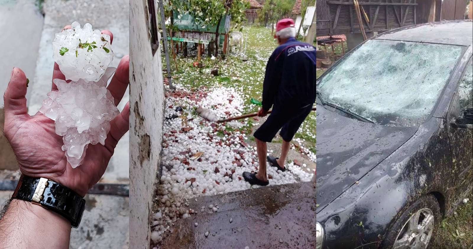
12 June: Serbia, Bulgaria, and Russia were affected by severe hail. Over Bulgaria, a hailstorm tracked 170 km across the country, producing hail up to 8.5 cm in diameter, and damaging cars, roofs, house facades, and vegetation. The worst damage was reported from the village of Sheremetya. In Serbia, the largest hail reached 7.5 cm in diameter; in Russia, the largest hailstone was 7 cm across.
Photos by Stefka Pencheva (Darlevtsi, Bulgaria). Source: Facebook
13 June: This day was one of the most severe hail days of 2024 across Europe. In total, 240 large hail reports were collected. Significant hailstorms formed in a belt from Bosnia through Serbia into southern Romania and Bulgaria. Dozens of reports were also collected from southern Russia. Two long-lived hailstorms tracked across Bulgaria and from eastern Serbia to Romania with hail swaths over 200 km long. Serious hail damage was reported from all three countries and in many places, hail was accompanied by severe wind gusts. In Bulgaria, the largest hail reached 8.5 cm across, and hundreds of houses were damaged in the village of Shipka. Hail reached 7 cm in Serbia and Romania, where extreme wind-driven hail damage to crops was reported east of Bucharest.
Photo by Mariana Balasa (Progresu, Romania). Source: Facebook
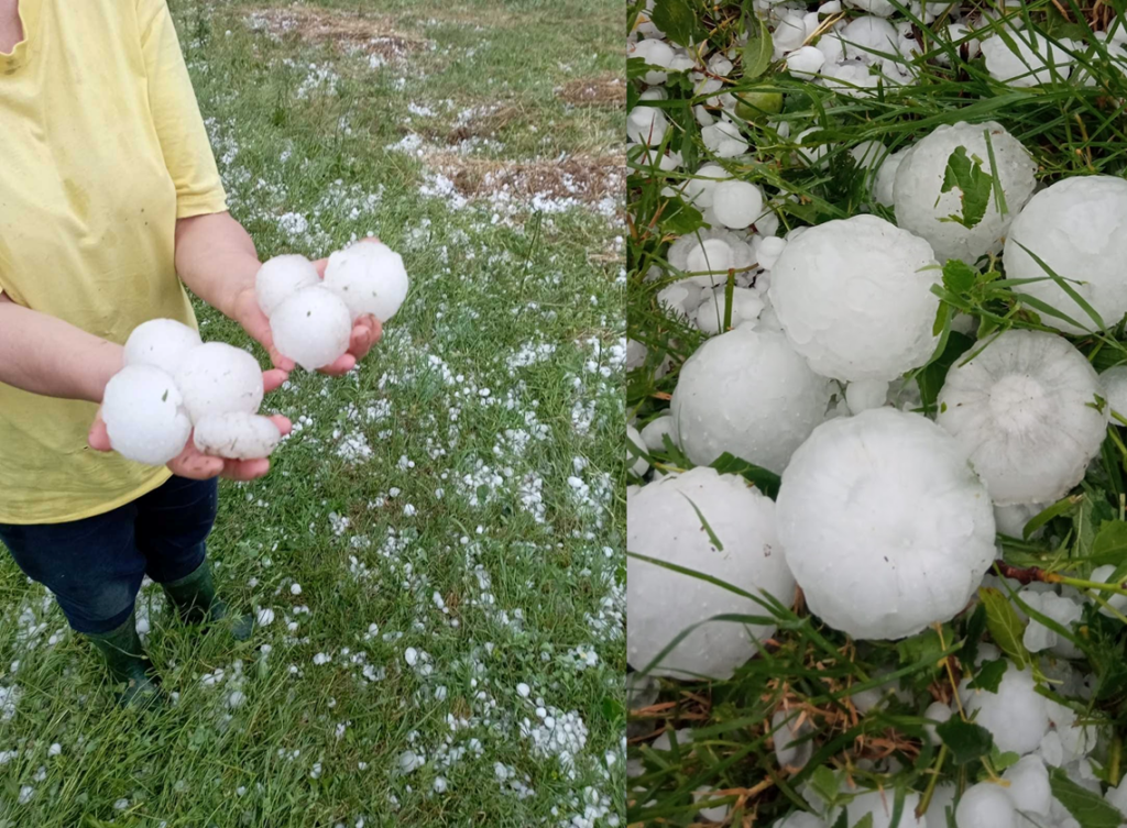
21 June: Another big day with 242 reports of large hail submitted to the ESWD, mostly from Czechia, Italy, and Germany. In Czechia, multiple supercells developed, each producing hail exceeding 5 cm. The largest hail, reaching 9 cm across, fell in Hluboké Mašůvky, a small village on the border with Austria. In Italy, a supercell produced hail up to 8 cm in diameter.
22 June: Report-wise, the spatial scale of the event was similar to the day before (220 reports of large hail), but the intensity and impacts were much more pronounced. The day started with a mid-day wind-driven hail event in Poland, especially affecting Harta and Dynów. Hail reached 7 cm in diameter, severely damaging roofs, facades, windows, cars, and crops. In the afternoon, multiple supercells formed over Bosnia, each producing hail exceeding 5 cm in diameter. Three storms produced giant, 10+ cm, hail. The largest hail fell in the town of Prnjavor, reaching 11 cm across. Extensive damage to roofs and cars was reported. Hailstorms also affected western Serbia, especially the town of Osečina. Here, densely falling wind-driven up to 8 cm in diameter caused extreme damage to crops, vehicles, and roofs. The storm also killed animals and caused an unknown number of injuries. Towards the evening, storms formed also over Hungary, with hail reaching 8 cm in diameter.
Photos by Бојан Пиљагић and Opština Osečina (Osečina , Serbia). Source: Facebook
23 June: Storms continued to produce large hail across southeastern Europe. The largest hail fell in the town of Sjenica, Serbia, reaching 10 cm in diameter and damaging cars. Very large hail was also reported in Bosnia and Kosovo. In Kosovo, the largest hail was 8.5 cm across.
Photo by Hedija Ahmetović Burović (Sjenica, Serbia) and Sami Haĵdari (Dobroshec, Kosovo). Source: Facebook
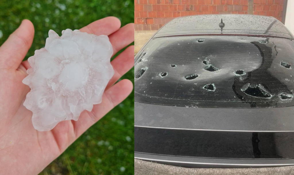
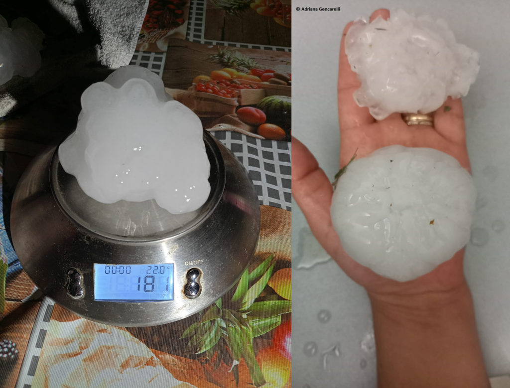
29 June: A brief, intense supercell produced hail up to 12 cm in diameter in Piemonte, Italy, damaging cars, roofs, and solar panels. 2 people were injured.
Photos by Chiara Querio and Adriana Gancarelli. Source: Facebook.
30 June: Severe hailstorms were reported in Austria, Czechia, and Poland. The most severe event occurred in Austria, specifically in the municipality of Waldkirchen an der Thaya region with hail reaching 7 cm in diameter. 80% of the buildings in the affected villages sustained damage to roofs, facades, windows, or solar panels, and the region was declared a disaster area. Very large hail up to 6 cm also fell in southern Czechia and up to 6.5 cm in central Poland.
1 July: Severe weather occurred in a belt from northwestern Italy through Slovenia, Croatia, and northern Bosnia into Serbia. The day’s main event started with supercells forming over Slovenia and producing very large hail up to 5.5 cm in diameter. Storms strengthened as they moved over Croatia with one of them producing an eccentric hailstone with an estimate of 11 cm size of its longest axis in the village of Budaševo. One of the supercells tracked for 260 km, lasting 5.5 hours. The most damaging phase of the hailstorms came later on when the hail combined with the severe wind gusts on the border of Croatia, Bosnia, and Serbia. A particularly destructive wind-driven hail event was reported from Bošnjaci with significant damage to at least 1500 buildings. Roofs, windows, and facades were heavily damaged and animals were killed. In Serbia, the hail reached 7 cm in diameter and 1 person was injured.
Photos by Ivan Baboselac (Crometeo) and vlč. Josip Levaković (Župa Bošnjaci). Source: Facebook
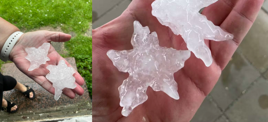
6 July: A supercell produced a swath of very large hail across Denmark. Hail had very eccentric shapes with pronounced lobes, leading to very large dimensions across the longest axis, up to an estimate of 10.5 cm. Hail damaged cars and roofs, and was by far the largest hail reported to ESWD from this country.
Photos by Dennis Hede ( source: Facebook) and Martin Grønbech (source: Seerfoto)
11 July: 328 large hail reports were submitted for this day, most of them from France. Poland, Czechia, Germany. and central Russia were also affected. In France, multiple supercells formed, producing hail locally exceeding 5 cm in diameter. Three hail swaths were more than 100 km long. The largest hailstone fell in Mazères-de-Neste and was estimated at 9 cm across. Severe hail activity continued from the early afternoon to late night, damaging roofs, cars, and crops. In Czechia and Poland, supercells produced hail up to 7 cm in diameter.
12 July: The biggest large hail day of 2024. 753 reports were submitted to the ESWD. Hail fell in a belt from France through northern Italy, Switzerland, and Germany into Slovenia, Austria Czechia, and Poland. In France, an early morning hailstorm caused damage with hail reaching 5 cm in diameter. In Italy, two supercells brought large hail. The most prominent one tracked through parts of Milan and produced hail up to 9 cm in diameter, injuring 4 people. In Germany, several storms produced long swaths of hail up to 7 cm in diameter. While the majority of hail tracks involved hail < 5 cm, 30,000 ha of farmland were damaged in the country. One of the hailstorms produced a hail swath 300 km long. In Austria, hail up to 6.5 cm in diameter damaged roofs, windows, facades of houses, and photovoltaic panels. In Slovenia, hail up to 6 cm was reported.
Source: PRETEMP
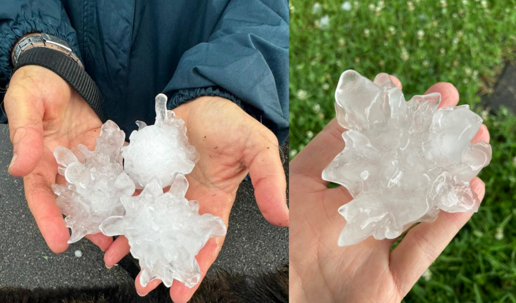
13 July: 313 large hail reports were submitted mostly from Slovenia, Hungary, Poland, and Belarus. The most severe hailstorms occurred in Slovenia, where two supercells formed in the afternoon and moved towards Hungary. Giant hail was reported in and around Slovenska Bistrica, and the largest hailstone was estimated at 12 cm across. Roofs, cars, greenhouses, and solar panels were damaged. In Hungary, the hail reached 5 cm, and in Croatia, 7 cm in diameter. In Poland, an intense overnight elevated supercell produced a long swath of wind-driven hail up to 4 cm in diameter.
Photos by Marko Kresnik and Anja Šuligoj Kegl. Source: Facebook
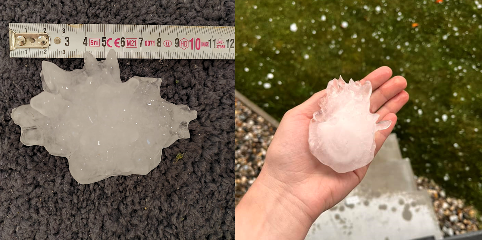
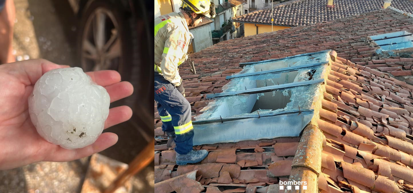
2 August: Very large hail was reported from Andorra, Italy, France, and Spain. In Italy, an intense storm developed right over Torino, producing hail up to 7 cm in diameter and causing widespread disruption to traffic and damage to cars, roofs, and windows. 1 person was injured by hail. In Spain, two supercells produced hail up to 8 cm in diameter. The biggest impact was recorded in Sant Pere de Torell, Catalonia, where hail badly damaged at least 1000 roofs and 300 cars. In France, hail reached up to 6 cm in diameter.
Photos by Lola Colina (source: Facebook) and Bombers Catalonia (source: Twitter)
3 September: A supercell developed in the Valencia region, Spain, and produced hail up to 11 cm in diameter in the village of Agullent.
8 September: A supercell developed in Tuscany, Italy, and produced hail up to 9 cm in diameter in Camaiore municipality. Damage to roofs and cars was reported and hail injured one person.
28 October: 11 300 ha of crops were damaged by a late evening hailstorm in Andalusia region. Hail up to 7 cm in diameter damaged many cars in the town of Santa María del Águila.
This short article discusses the conditions leading up to the devastating flash floods in the Valencia region on 29 October 2024. We also briefly discuss some storm characteristics from the perspective of the satellite data. Please note that we concentrate on the meteorology, but neither climatology nor the social aspect of the disaster, making this writing far from exhaustive.
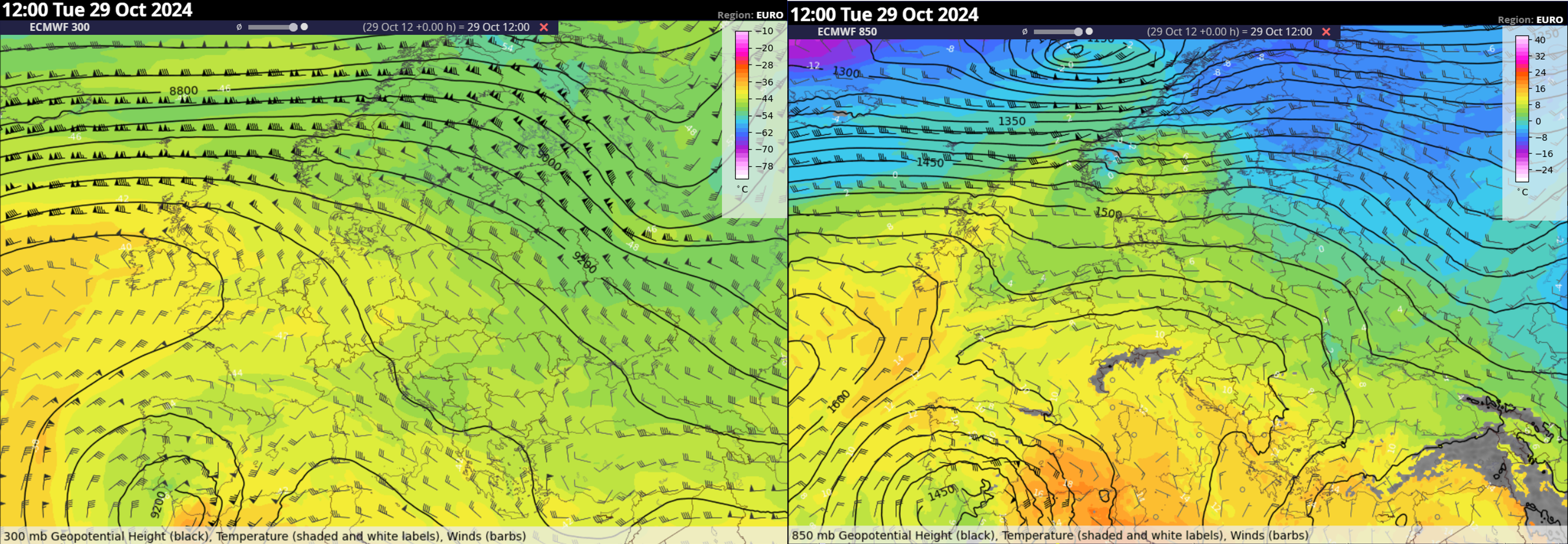
The synoptic scale was characterized by a deep cut-off low over northwestern Africa and southern Spain. At the upper troposphere, a left exit region of a jet streak was located over southeastern Spain and shifted north during the day. Closer to the ground, a strong easterly low-level flow, with wind speeds up to 25 m/s at 850 hPa overspread eastern to central Spain with persistent warm air advection across the area. The low-level jet was lifted over the local topography on the eastern coastlines, initiating the development of the storms.
ECMWF analysis of the 300 and 850 hPa geopotential height, temperature and wind at 12 UTC.
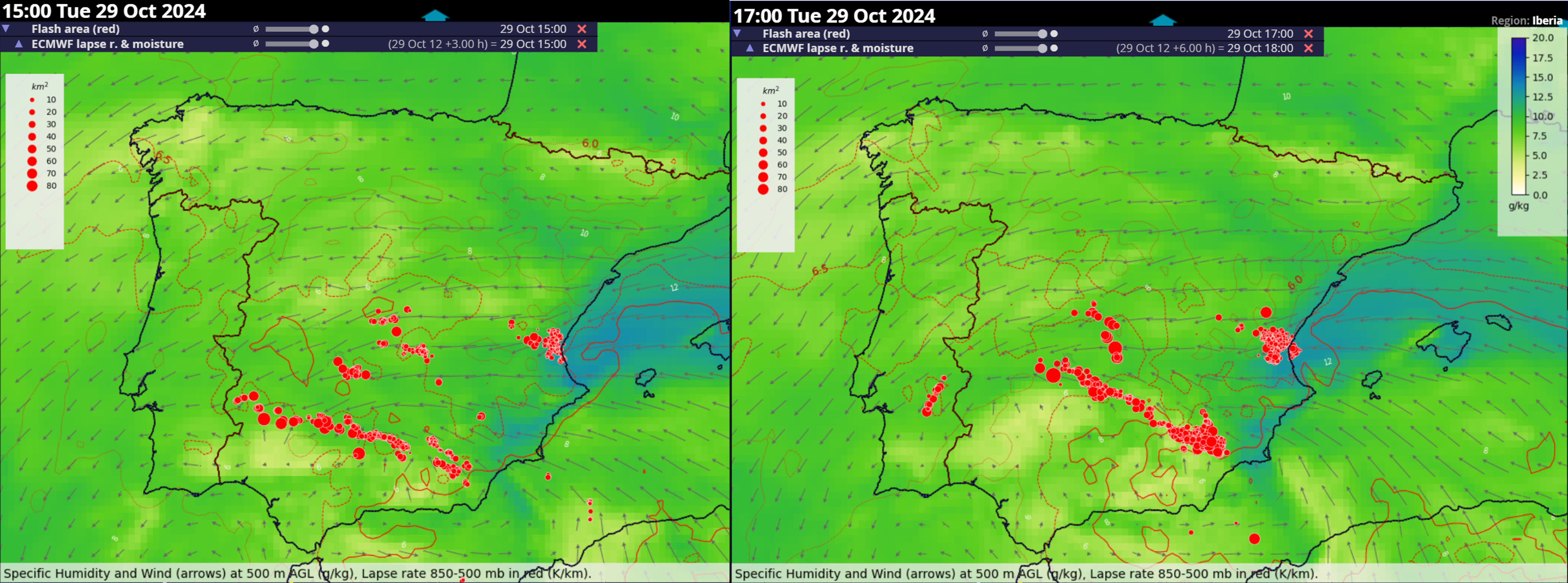
Southerly mid-tropospheric flow advected steep lapse rates from the Sahara over the Balearic Sea. The models simulated a notable overlap of steep lapse rates (exceeding 7 K/km between 850 and 500 hPa) and abundant lower tropospheric moisture (exceeding 12 g/kg in the lowest 500 m). This yielded a high CAPE environment, especially over the sea and coastlines. Figure below shows the persistence of these ingredients just east of Valencia as the quasistationary storm was happening. High CAPE combined with substantial vertical wind shear, a situation with a high conditional probability of severe weather should storms form.
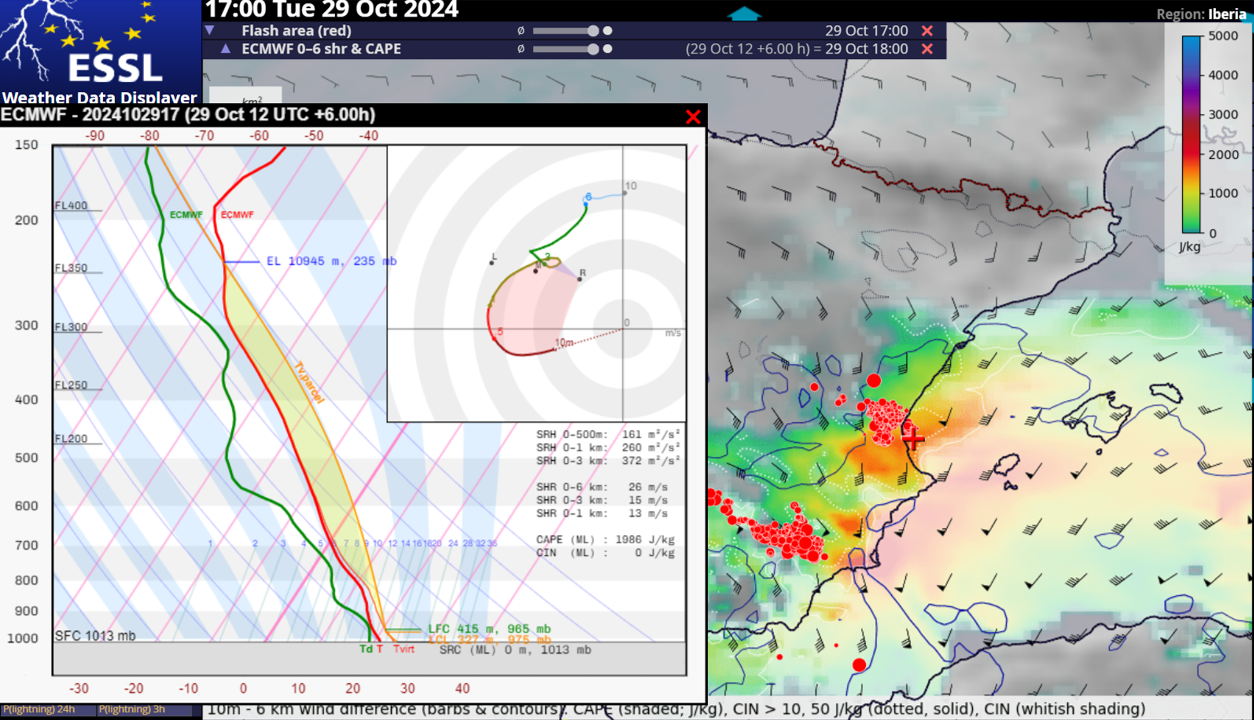
ECMWF 12 UTC forecast of 15 and 18 UTC lapse rates (red contours), specific humidity (color shading) and wind vectors at 500 m combined with a 15 and 17 UTC flash area (red dots) based on the Lightning Imager of the MTG. Note the position of the Valencia storm at the tip of the tongue of very moist airmass.ECMWF 12 UTC forecast of 18 UTC MUCAPE (color shading), 0-6 km bulk wind shear (barbs) combined with a 17 UTC flash area (red dots) based on the Lightning Imager of the MTG. Red marker just east of Valencia shows the location of the plotted forecast profile.
The storm produced high rainfall intensities over several hours, and at least three tornadoes rated IF1, IF1.5, and IF2. According to AEMET, the hourly record rainfall in Spain was broken in Turis, with 184.6 mm in 1 hour and 42 mm in just 10 minutes. Overall the station received 771.8 mm in 14 hours. Weather station Chiva reported 491.2 mm in 8 hours, 343 mm in 4 hours, and 160 mm in 1 hour.
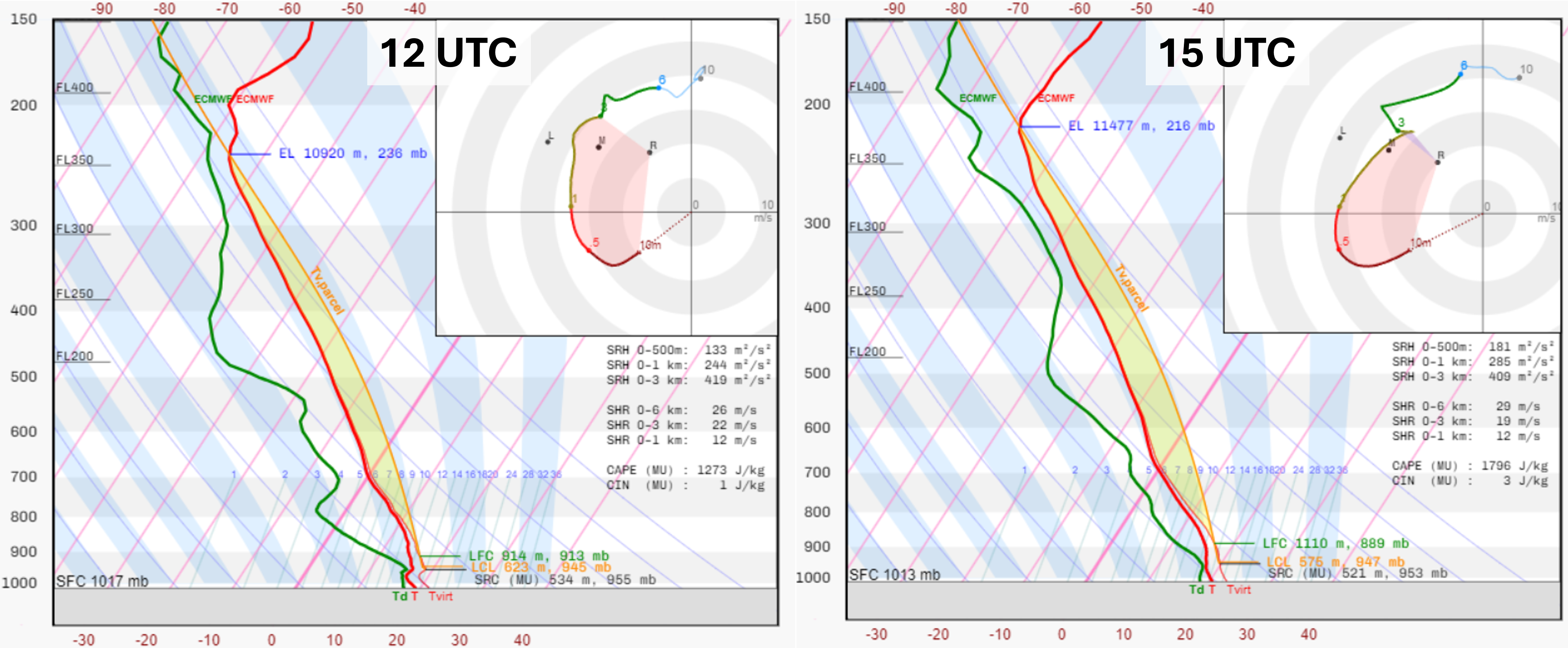
Because extreme rainfall produced a much larger impact than tornadoes, we will mostly concentrate on the ingredients-based forecasting of this phenomenon, following the work of Doswell et al. (1996). The authors separate the ingredients for rainfall intensity and its duration. The intensity is a function of the supply of low-level moisture, its vertical flux, and the “efficiency”. The efficiency is the ratio of the amount of rainfall that reaches the ground to the amount of rainfall formed in the storm. The evolution of the forecast temperature and humidity profiles and hodographs just east of Valencia in the inflow zone of the storm shows an improvement in the ingredients for high rainfall intensity between 12 and 15 UTC.
Skew-T log p diagram of the ECMWF 12 UTC analysis and 15 UTC forecast and hodograph over the sea just east of Valencia.
By 15 UTC, these ingredients were present over the area:
High absolute moisture content in the lower troposphere rapidly advected towards the coast with wind speeds up to 25 m/s in the bottom 500 m.
High potential for rapid vertical flux of moisture due to high CAPE
High precipitation efficiency due to low-cloud bases, and high relative humidity in the low to mid-troposphere, resulting in a low potential for evaporation of rainfall.
Considerable depth of the cloud available for the growth of raindrops through collision and coalescence, given by the large distance between the lifted condensation level and the 0° isotherm (so-called deep warm cloud depth)
The intensity and the width of the precipitation swath were likely increased by the presence of strong vertical wind shear, both in the bottom 1 km and above it. Observations and idealized simulations have shown that precipitation rates are increased through shear-induced enhancement in the low-level updrafts (Smith et al. 2001, Nielsen and Schumacher, 2018Nielsen and Schumacher, 2020). The width of the precipitation area is also increased by the stronger shear (and conversely, strong inflow) producing wider updrafts (Mulholland et al. 2024). This was especially important in this case, which featured low cloud bases, which typically result in narrower updrafts.
Precipitation fell over the area in several rounds. The first convective system affected the Valencia region already in the morning hours. A decrease in activity was noted during the late morning with drier air in the low to mid troposphere advected over the region. The main phase with a quasi-stationary storm started around 14:30 UTC and lasted till 18 UTC.
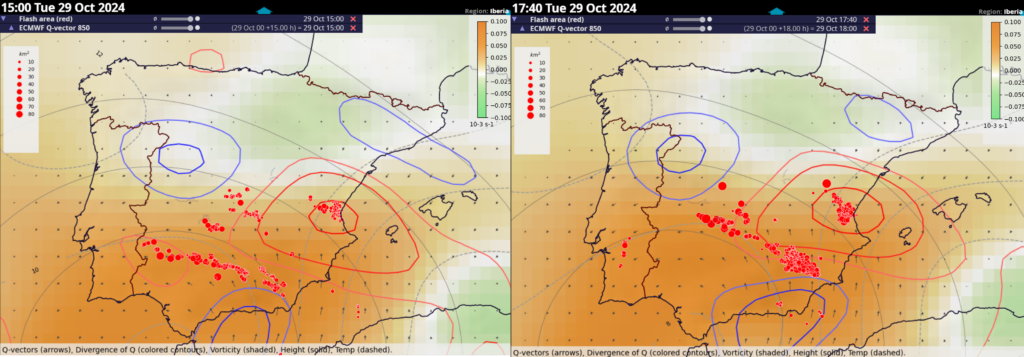
ECMWF 12 UTC forecast of 15 and 18 UTC Q-vector convergence (blue and red contours), and vorticity (color shading) at 850 hPa combined with a 15 and 17:40 UTC flash area (red dots) based on the Lightning Imager of the MTG.
There were several factors contributing to the quasi-stationary nature of the storm in the area:
Persistent maximum of synoptic-scale lift at 850 hPa caused by warm air advection
Persistent strong easterly onshore flow ascending the local topography
Tongue of higher low-level moisture and CAPE upwind of the initiating storms resulted in back building
High relative humidity in the low troposphere combined with low cloud bases. This resulted in weak or absent cold pools that would push the initiation of new cells to other locations.
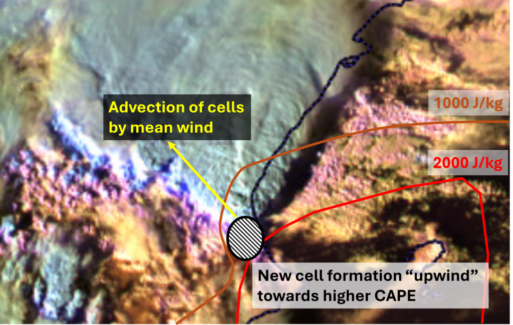
The storm showed the typical pattern for quasistationary rainstorms in the Mediterranean, with the higher moisture and CAPE remaining over the sea, while the storms form over the coastline and are advected further inland. This results in opposing directions of cell advection by mean wind and new cell formation towards the area of higher CAPE. This process applied in this case and is schematised below.
MTG Cloud phase RGB at 15:40 UTC combined with a schematic showing the distribution of CAPE in the area (brown and red contours), the orientation of the mean wind vector, and the region where new updrafts are initiated (ellipse with black stripes).
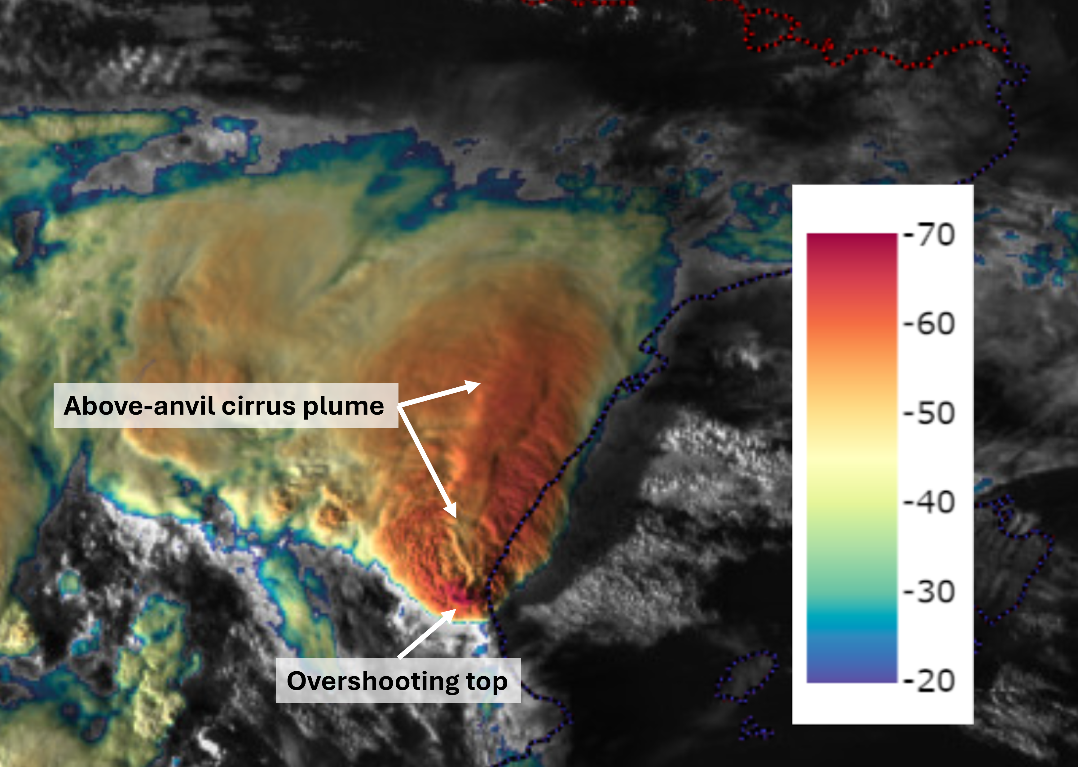
The storm that ensued looked extremely intense from the satellite’s perspective. It displayed a persistent, cold, and wide overshooting top with a long above-anvil cirrus plume advected in the direction of upper tropospheric storm-relative winds. Both features are shown in the figure below. The animation of the “Sandwich” (combination of visible and infrared channels) shows the long-lived nature of the features as well as the rapid expansion of the anvil. The above-anvil cirrus plume becomes more prominent towards sunset as the low sun angle creates longer shadows.
MTG Sandwich imagery at 16:10 UTC with colour representing the cloud-top temperature based on the IR channel.
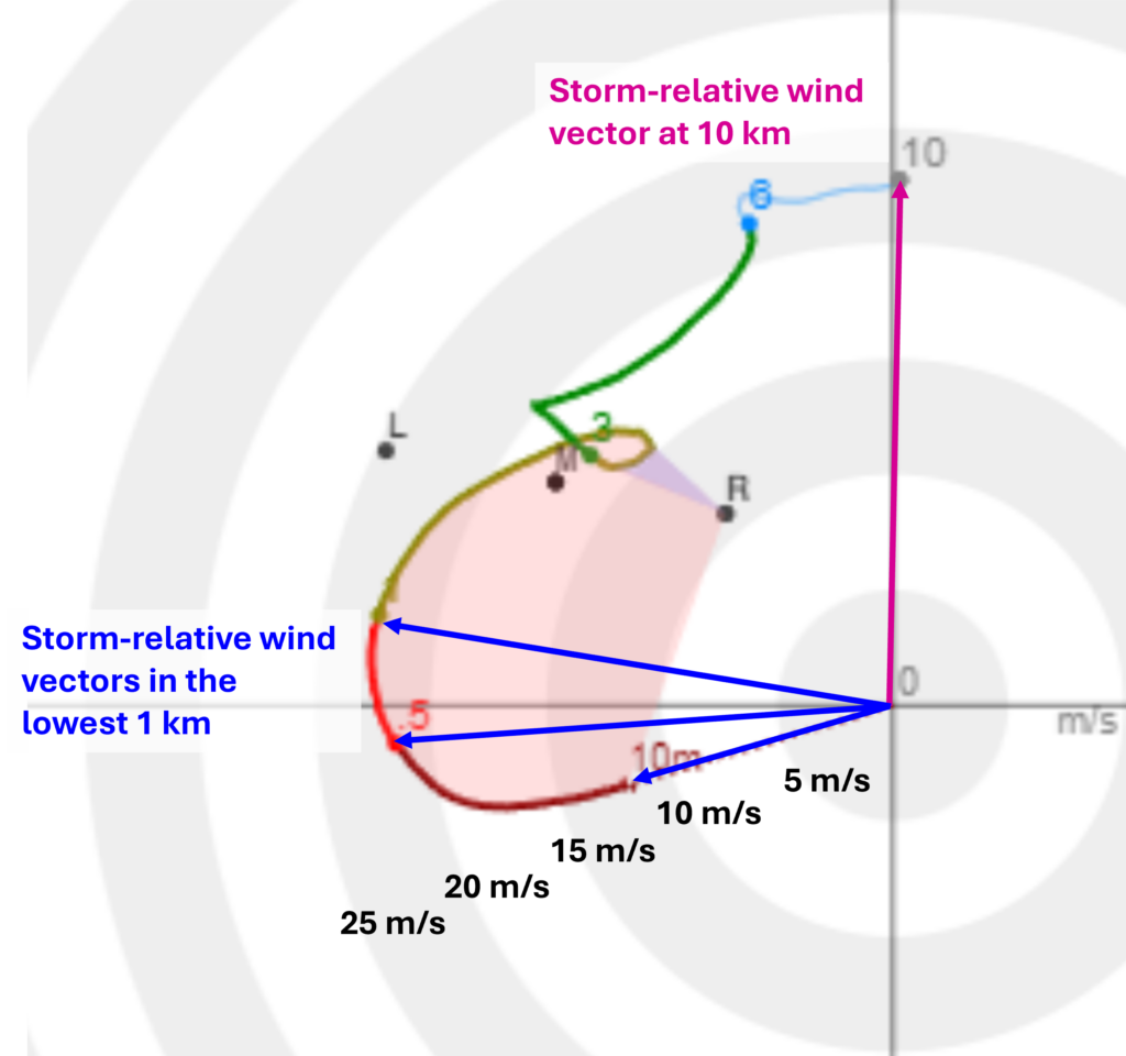
The nature of the storm top features reflected the environment in which the storm formed characterized by high CAPE and strong upper tropospheric storm-relative winds, which helped to create a hydraulic jump downwind of the overshooting top (Homeyer et al. 2017). The quasi-stationary nature of the main updraft of the storm resulted in strong storm-relative flow both in the upper troposphere and near the surface. The storm-relative inflow reached up to 22 m/s in the bottom 1 km, which greatly increased the updraft width and the vertical moisture flux (Peters et al. 2020). Interestingly, although the storm had a persistent, strong, and wide updraft in the upper troposphere, there was no large hail reported to the European Severe Weather Database.
ECMWF 12 UTC forecast of the 18 UTC hodograph east of Valencia over the sea outside of the convective activity. Numbers on the hodograph represent altitude in km. Blue and purple vectors indicate the storm-relative winds in the lowest 1 km and at 10 km assuming the updraft of the storm was not moving.
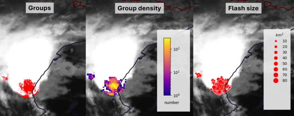
Strong moisture flux through the charging region of the storm resulted in very high lightning activity. Some of the products available from the new Lightning Imager are shown below, showing a high density of lightning in the core of the storm. Some of the flashes were also detected from the southern side of the storm due to the angle of the scanning of the satellite, forming a curious U-shape around the edge of the anvil.
MTG Lightning Imager data at 16:35 UTC showing different products available to the forecasters: event groups, event group density, and flash sizes. More information on the the Lightning Imager and disseminated products can be found here.
In summary, a high-end environment for severe convective storms existed over the area from the perspective of high CAPE and strong vertical wind shear. This resulted in well-organized storms with strong updrafts and a high precipitation intensity. The continuous strong onshore flow of a very moist airmass, in combination with a persistent maximum in the low-level synoptic- and mesoscale-scale lift over the area kept the updraft redevelopment locked in the same position for several hours. This resulted in the extremely high precipitation intensity to persist for several hours.
Last but not least, ESSL would like to extend its deepest sympathies and condolences to the people of Spain, who have suffered from this horrifying natural disaster.