Afternoon nowcasting session

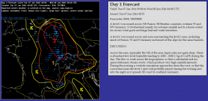
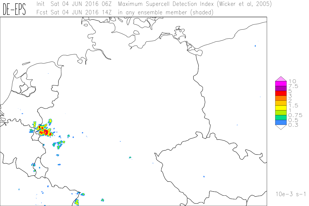
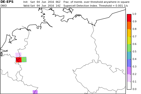
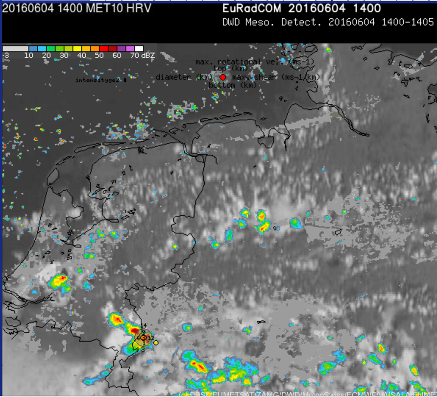
We had an interesting afternoon session with much convection affecting the area that was highlighted in the Day1 outlook. Having pulsating convection, the collision of different storms as well as several convergence lines that we analysed in the surface maps, it was quite challenging to tell about the further development of the convective situation, especially over Northeastern France.

P1010283

The main focus was on excessive precipitation events. 12 UTC soundings showed almost no wind speed throughout low- and mid levels. So it was quite likely that storm movement is quite small and driven by the dynamics of the storms (cold-pool).  In addition rather humid vertical profiles with steep lapse rates were visible.

2016060712.07145.skewt.parc

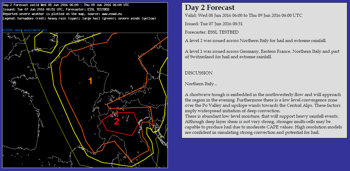
While team 1 was concentrating on the Western domain where we have issued the outlook for, team 2 was looking for northern Germany were storms organized along a pronounced convergence line. Having in mind the situation yesterday and the day before, the participants decided to include tornados in their mesoscale discussion. This finally was the right decision having a first report of a tornado near Hamburg (https://www.facebook.com/Wetterspiegel.de/videos/1108717095860456/).

Tomorrow will probably be another interesting day with short wave features that introduce a synoptic-scale lift mechanism.

Share

First outlook preparation

Today we have started to prepare the first outlooks of the week. Therefore the participants were divided into two groups.

Group 1 was working on the day 1 outlook. They first started to make a surface analysis to diagnose the current distribution of low level moisture and the separation of warm and cool airmasses. In addition they were looking for convergence zones that might become interesting throughout the day. Although there have been quite a few differences the hotspots were anticipated by all surface analysis.

Bild5 Bild6

With the help of the soundings from 00 UTC it was also found out, that in the area of interest there was quite a good overlap of steep mid-level lapse rates and humidity. Whereas humidity was enhanced to the southwest, lapse rates became steeper to the northeast.


After that, the model output and the high-resolution ensembles have been studied to find out which regions will also stay under the influence of these good ingredients in the afternoon hours. The following map shows what the outlook at the end looked like.

Day1-Outlook

The main hazard is excessive precipitation due to the high humidity values in combination with almost non-existing storm motion. The lack of deep layer shear mostly prevents from big hail. However it cannot be excluded for local mesoscale developments. Also a local wet downburst cannot be ruled out given a somewhat larger spread in low-layer as seen in some of the 00 UTC soundings. Finally, having the almost non-existent flow in mid-level (850 to 500 hPa) and the development of local convergence zones it is also possible that we may see one or two tornados (landspouts).


What was in addition interesting is the approaching vorticity maximum from the west that is already visible in water vapor satellite images. This may lead to ongoing convection throughout the whole night.

Bild8

Short wave trough(s) are also interesting for our day 2 forecast.  Since these features are accompanied with synoptic scale lift mechanisms that should enhance convective activity and in addition lead to better organized convection. Especially in the Po valley were the first short wave trough arrives in the afternoon hours also quite a lot of low level moisture will be present. Also the model output does enhance convective activity in that area. So this is why a LVL2 was issued in that region. The main threat again is excessive precipitation but also large hail is possible especially in the LVL2 area.

Bild7Day2-Outlook

So … finally an interesting setup. Looking forward to the nowcasting session during the afternoon.


Share

An impressive COSMO DE-EPS forecast

Last Saturday unorganized convection was dominating in a low-shear environment, but a few cells became severe and some of them produced large hail according to the ESWD. One outstanding development occured in the border region of the southernmost Netherlands and neighbouring Germany.

Interestingly, COSMO DE-EPS produced nearly perfect forecasts of this development in three consecutive initialization times (see example for 06 UTC model initiation):

20160604 8_maxsdi

Supercell Detection Index (maximum SDI of all ensemble members) for 14 UTC
20160604 8_upssdi

Fraction of 20 ensemble members exceeding a threshold for the SDI: more than 90 % in the correct 40×40 km box, while the rest of the domain was correctly modelled free of such an intense development.
20160604 Radar

High resolution visible satellite and radar overlay of reflectivity and Mesocyclone Detections at 14:05 UTC.

An interesting example for the potential of high resolution ensembles that we found in the very first hours of this years’ Testbed.

Share