
Did somebody’s lament (“That really sucks if it is July and the best storms can be found in Northern Africa!”) yesterday help? We don’t know. Anyway, the second day of the first Testbed week turned out to be more interesting than anticipated.
The verification, which opened up our daily program, revealed that yesterday (Mon 1 July 2013) evening and night quite a number of storms had popped up along the convergence line across Northern Germany and Poland mentioned in yesterday’s weather summary. A handful of marginally large hail (2 cm) and heavy rain events was reported with this activity, hence a level 1 area might have been the better choice along with the well predicted thunder areas (Fig.1). The mesocyclone detection algorithm, which is provided by the German Weather Service (DWD) and based on the German radar network, recognized at least weak rotation with almost every other of these storms. This suggests that a number of supercells was interspersed, which is rather surprising, considering a rather modest background of environmental conditions (CAPE likely below 500 J/kg, 0-6 km vertical wind shear not above 15 m/s).
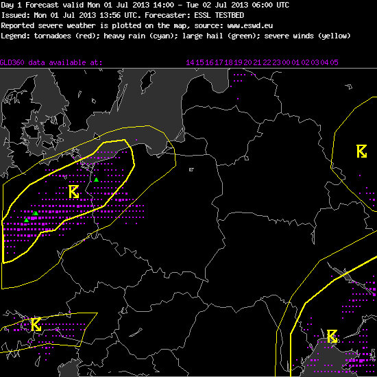
Fig.1: Verification of the day 1 forecast for Mon 1 July 2013. Magenta dots: lightning detections (VAISALA GLD360), green triangles: large hail reports (ESWD).
The same boundary and an accompanying short-wave trough were again the main focus for thunderstorms today on their further way to the E and SE, embedded in an equally modest-looking setup of limited CAPE and shear. After the team for day 1 forecast (for today, Tue 2 July 2013) had largely confirmed Monday’s day 2 forecast with two low-end level 1 areas for large hail in parts of Poland and Central France, from noon onward scattered thunderstorms formed over Poland, E Germany, the Czech Republic and E Austria. These storms soon became very interesting for the nowcasting activities during the afternoon (Munich domain). Two handfuls of reports of 2-3 cm sized hail appeared in the ESWD in the following hours, along with a few additional reports of heavy rain, of which, however, at the time of writing it is still unclear if they indeed match our criteria (substantial damage inflicted). This hail and rain risk was correctly seen by the nowcasters, while some individual events remained elusive enough to occur outside of the drawn watch areas. As an example, Fig. 2 shows the 13 UTC nowcast (valid from 13 to 15 UTC), which correctly captured two hail events in Poland, closely missed a hail and a rain event in the Czech Republic and missed an isolated hail event in Austria. The latter was associated with a strong multicell storm which also caught our eyes at the Testbed site in Wiener Neustadt, but it stuck to the Alpine rim with continuous backbuilding and failed to descend into the forelands.
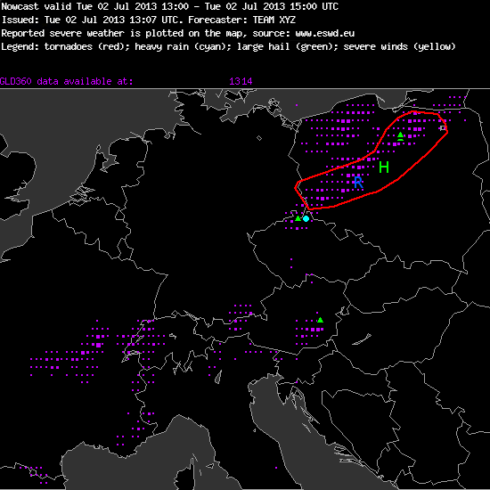
Fig. 2: Verification of the nowcast issued at 13 UTC Tue 2 July 2013, valid for the 13 to 15 UTC period. Red line: watch area for a hail (“H”) and heavy rain (“R”) risk; magenta dots: lightning detections (VAISALA GLD360); green triangles and blue dots: large hail and heavy rain reports (ESWD), respectively.
In general, the aptitude of today’s convection to produce (at least marginally) large hail was perceived higher than a priori expected. We also noted that the strongest storms conspicuously formed beneath a pronounced pink band in the “air mass” satellite product, which illustrated a streamer of very dry air in the upper troposphere, a so-called dry intrusion (Fig. 3), which accompanied and illustrated the sharp upper-level trough.
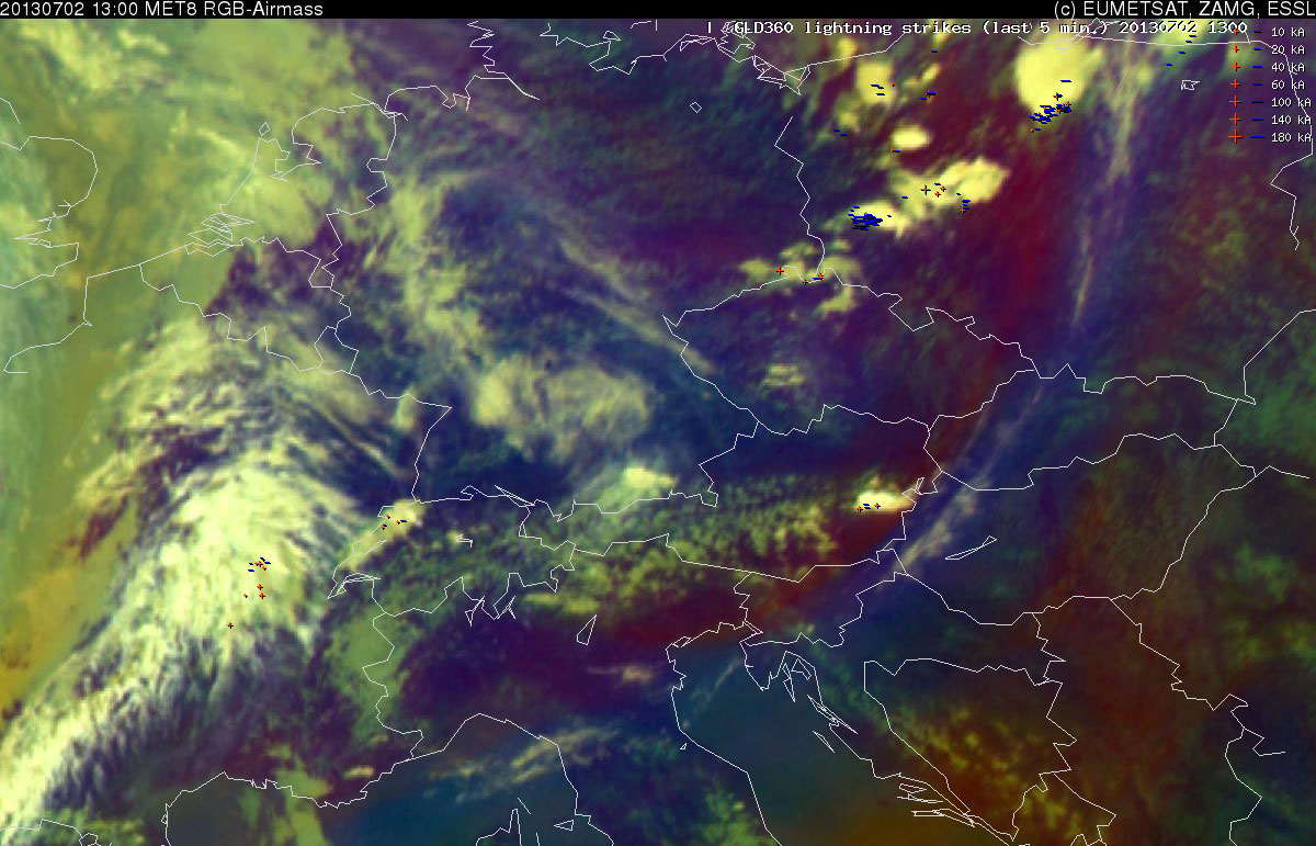
Fig. 3: Meteosat RGB air mass satellite product at 1300 UTC Tue 2 July 2013 plus lightning detections within the last 15 minutes.
We assumed that large-scale lift of the whole column of air ahead of this trough managed to steepen the vertical temperature gradient across the lower and middle troposphere, as it was quite impressively shown by the 12 UTC soundings across the region – from North to South: Lindenberg (DE), Wroclaw (PL), Prague (CZ), Kuemmersbruck (DE), Munich (DE) and Vienna (AT) -, all of which exhibited a few hundred J/kg of CAPE (Fig. 4).
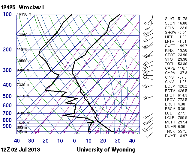
Fig. 4a.
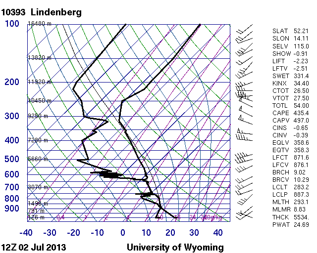
Fig. 4b.
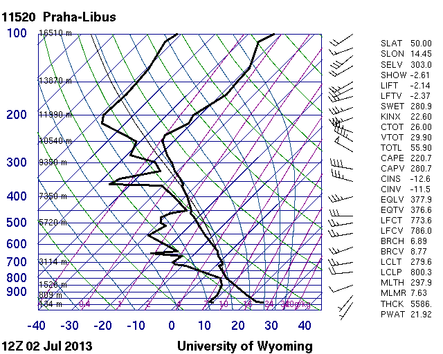
Fig. 4c.
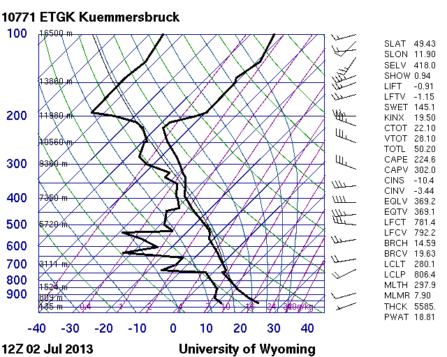
Fig. 4d.
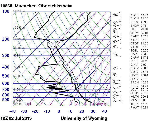
Fig. 4e.
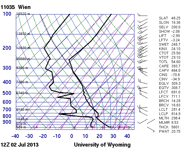
Fig. 4f.
This is in line with preliminary climatological studies with ESWD data, which suggest that CAPE mainly based on steep lapse rates is more conducive to hail formation than CAPE mainly based on rich low-level moisture. The latter would rather feature an enhanced heavy rain risk instead. An additional reason for today’s fairly large number of hail reports may have been stronger than forecasted deep-layer shear in the range of the short-wave trough, which would match our subjective impression of a sharper trough.
Tomorrow (Wed 3 July), another interesting day is in store for the Munich domain with the arrival of a weak cold front and another short-wave trough from the West, as it can be seen in the day 2 forecast issued by the other team (Fig. 5).
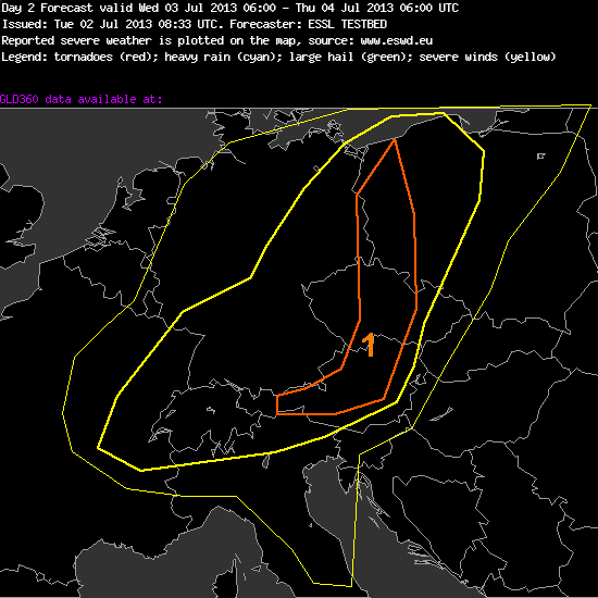
Fig. 5: Day 2 forecast for Wed 3 July 2013. Thin yellow line: >15% thunder probability; thick yellow line: >50% thunder probability; orange line: 5-15% probability of severe weather, all relating to a 40 km radius around a given point.
—–
Day 2 Forecast
Valid: Wed 03 Jul 2013 06:00 to Thu 04 Jul 2013 06:00 UTC
Issued: Tue 02 Jul 2013 08:33
Forecaster: ESSL TESTBED
Prefrontal of a coldfront which is moving eastwards slow moving thunderstorms will develop during the day and will only organize locally due to modest CAPE values and small vertical wind shear under 15m/s.
A level 1 warning is issued for northern austria, czech republic and western poland mainly for heavy rainfall and to a lesser extent for large hail which will rather develop in the eastern part of the level 1 area.
—–
Side note: the German COSMO shows the most “aggressive” solution and forecasts plentiful convective precipitation (> 50 mm) even over Wiener Neustadt tomorrow evening and in the first night hours, whereas the other models are more reluctant and keep the precipitation maximum a bit further to the West. Stay tuned!

This blog is real fun and informative 🙂 Keep this going!