
Phew! The atmosphere did not know any mercy and confronted the participants of the first Testbed week 2013 with a challenging start: no obvious hot spot for severe storms anywhere, but a lot of areas with an enhanced thunderstorm risk and marginal severe weather chances scattered across the continent.
After the day 1 forecast group (i.e., the forecasters for the present day, Mon 1 July 2013) could not decide whether to focus on the Helsinki or Paris domain, they ended up with choosing the Warsaw domain instead. This turned out to be a good solution, as it almost fully covered the area where most evening and nighttime convection was expected.
The weather pattern was characterized by a Westerly upper-level flow with warm air advection across many parts of Europe, in which the forecast models agreed on increasing low-level moisture and the evolution of a little CAPE (400-800 J/kg) in the afternoon and evening hours over Northern France, Belgium, the Northern half of Germany and Western Poland. Various sources of lift were soon identified: warm air advection and – later towards evening – the arrival of a quite pronounced short-wave trough would provide synoptic-scale lift. Closer to the surface, a wind shift line moved in from the Northwest, probably originating from an old cold front. Consequently, a >50% thunder probability area was issued for the Northern half of Germany and Western Poland. A >15% thunder probability area was additionally drawn over the Alps for isolated air mass thunderstorms. Severe weather was considered unlikely: vertical wind shear would only start to increase in the night, when no surface-based convection was expected any more which could fully benefit from it.
The 12 UTC soundings tempered the mood for a short time, as most of the Central European sites still featured a cap at ~850 hPa which would likely suppress convection. However, the soundings along the wind shift line – Trappes (France), Meiningen and Lindenberg (Germany) – already showed a litte instability which was almost uncapped. Indeed a band of growing cumulus clouds with first radar echoes and lightning strikes soon developed and showed the importance of the concentrated lift associated with this convergence line (Fig. 1).
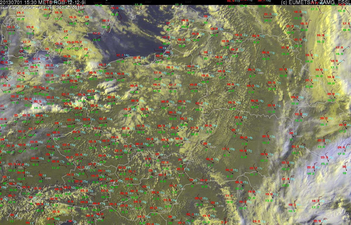
Fig. 1: Nowcast display at 1500 UTC Mon 1 July 2013: Meteosat E-view satellite image and SYNOP observations.
As this convection was still too modest to be interesting for the nowcasting session in the afternoon, the attention shifted to another area with thunderstorm activity in Northern Finland. Due to limited CAPE, weak vertical wind shear and some obstructive-looking cloudiness, this convection was initially considered unlikely to produce severe weather. However, after 14 UTC several storms connected to a line which moved Northwestward and tempted the forecasters to issue a watch area for severe wind gusts in their first nowcast (issued at 1430 UTC, valid for the 1430 to 1630 UTC period). This decision was not so much fostered by the conviction that indeed something severe would happen, but at least to an equal part by the desire to try the nowcasting tool. No watch area was drawn in the second nowcast (1530 to 1730 UTC) any more, as the convective line was already moving out of the Helsinki domain and the functionality of the nowcasting tool was successfully proven.
Meanwhile, the other group labored over the day 2 forecast (Tue 2 July 2013). They chose the Munich domain, where an increasing coverage of thunderstorms in the warm air mass was foreseen, and they even found two small areas where they could issue a level 1 mainly for a hail risk (Fig. 2):
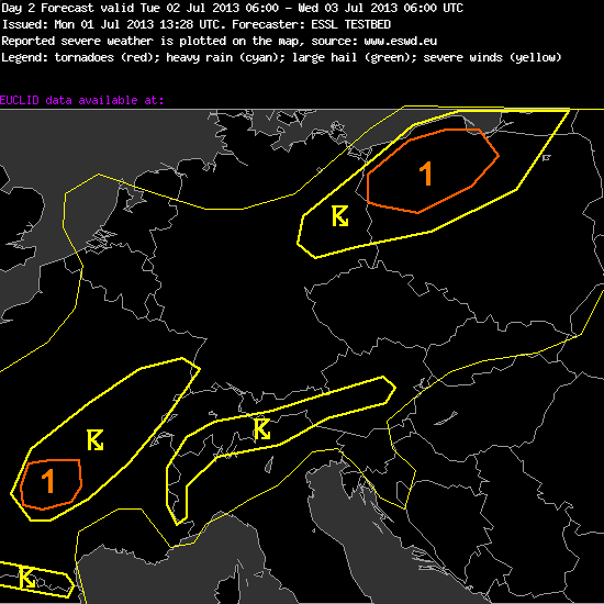
Fig. 2: day 2 forecast valid for Tue 2 July 2013. Thin yellow line: >15% thunder probability; thick yellow line: >50% thunder probability; orange line: low probability (5-15%) of severe weather, all relating to a radius of 40 km around a given point.
Day 2 Forecast
Valid: Tue 02 Jul 2013 06:00 to Wed 03 Jul 2013 06:00 UTC
Issued: Mon 01 Jul 2013 13:28
Forecaster: ESSL TESTBED
A level 1 was issued for NW Poland for large hail and to a lesser extent for excessive precipitation.
A level 1 was issued for south-central France for large hail.
Ahead of an strong mid/upper trough moving eastward from Germany towrds the northeast during the forecast period, moderately steep lapse rates and adequate moisture will aid to produce~500-1000 J/kg of CAPE. In combination with deep-layer wind shear of about 15 m/s, this provides the setting for a number of thunderstorm, some of which may produce 2-4 cm large hail across NW Poland. Almost front parallel storm motion may lead to some local excessive precipiation.
Across south-central France some 1000 – 1500 J/kg of CAPE may prove adequate for isolated large hail with storms developing across the Massif Central.
For the day 3 forecast (Wed 3 July 2013), the same group then identified a region with a low-end severe weather risk from Poland to the Eastern Alpine region. Day 4 (Thu 4 July 2013) and day 5 (Fri 5 July 2013) were finally declared unpredictable due to the huge model discrepancies. However, it was anticipated that the chances for better organized thunderstorms and severe weather would remain low due to the weak dynamics across most of the continent.
Of course we hope that the forecast models can better agree on a common scenario tomorrow (Tuesday). Conclusion after the first day of Testbed 2013: good spirit and an uncooperative atmosphere!
