
With the advance of a convergence zone and the associated increase of low-level moisture in the very warm air mass, a belt with daily widespread afternoon thunderstorms is slowly shifting eastward from Western into Central Europe these days. Due to still weak vertical wind shear, most of the storms continued to be poorly organized yesterday, but nonetheless they produced another round of excessive rain, large hail and severe downburst events scattered across France. The activity also started to spread into Western Germany, and the verification of yesterday’s day 1 forecast demonstrated that much of the severe weather events occurred further East than the issued level 1 areas (Fig. 1), similar to the day before. In the afternoon nowcasting session the same team struggled with the short-lived character and elusive nature of these pulse storms (Fig. 2).
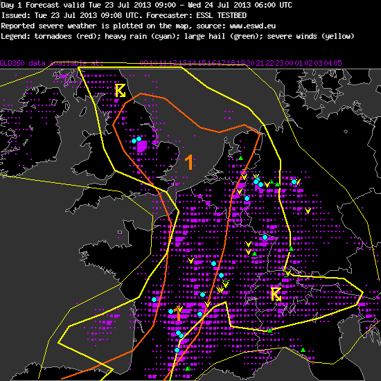
Fig. 1: Verification of the day 1 forecast issued yesterday (Tue 23 July 2013).
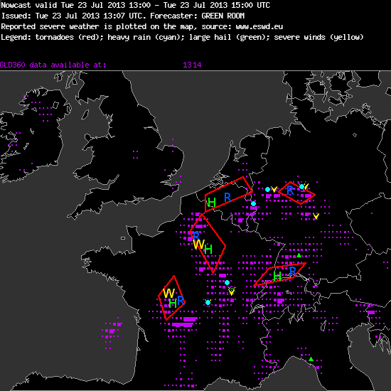
Fig. 2a: Verification of the nowcast issued at 13 UTC Tue 23 July 2013, valid for the 13 to 15 UTC period.
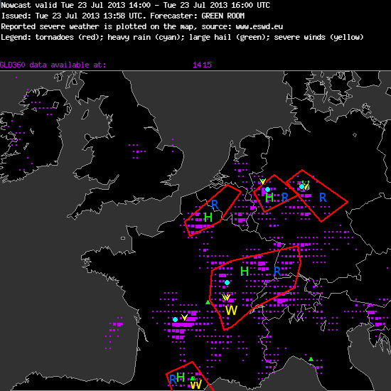
Fig. 2b: Verification of the nowcast issued at 14 UTC Tue 23 July 2013, valid for the 14 to 16 UTC period.
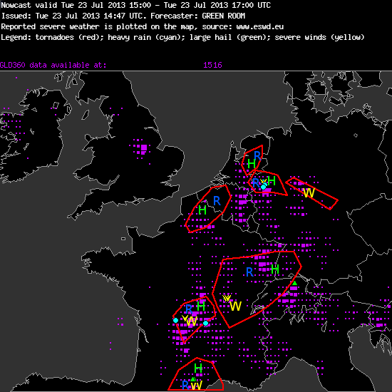
Fig. 2c: Verification of the nowcast issued at 15 UTC Tue 23 July 2013, valid for 15 to 17 UTC period.
Now that Germany finally starts to get affected by thunderstorms again after several exceptionally calm weeks, more of our attention starts to shift back to those of our tested products which are confined to the German area, namely the high-resolution COSMO-DE ensemble prediction system, the NowcastMix product for an automatic warning guidance and the mesocyclone detection algorithm. All of them have been developed and provided by the German Weather Service (DWD).
Ongoing complaints that the forecast models tend to mis-estimate (and, in particular, undererstimate) the pulse storm activity of the current weather period led to a closer comparison of the CAPE and precipitation forecasts today, which provides a good opportunity to highlight the COSMO-DE ensemble prediction system (in the following: COSMO-DE EPS). Its individual runs receive their initial and boundary conditions from 4 different global models (ECMWF, GFS, GME and JMA) and are computed with 5 different model physics packages, resulting in a total of 20 ensemble members. The horizontal resolution of 2.8 kilometres is impressively fine.
The following images illustrate the panel of 4 different visualizations of COSMO-DE EPS that we have made available for our Testbed, using the forecasts of radar reflectivity for 14 UTC yesterday (Tue 23 July 2013) as an example (base time: 06 UTC). Fig. 3 presents the envelope maximum simulated radar reflectivity of all model runs, which can be interpreted as a “worst case scenario”. In Fig. 4, areas with forecast radar reflectivity greater than 40 dbZ are highlighted with various colours, each of which belongs to one particular EPS run; this display is particularly neat because the user can track these colour-coded features from one forecast time step to the next. In Fig. 5, this information from Fig. 4 is condensed to the percentage of model runs which simulate a radar reflectivity greater than 40 dbZ; here, the “personal identity” of the individual EPS runs gets lost, but on the other hand you get an impression of how many EPS members exceed the threshold, which could not be seen from Fig. 4. All in all, Testbed participants can largely agree that this visualization is very useful and that the various displays ideally complement one another.
Fig. 6 shows the radar reflectivity forecast of the deterministic COSMO-DE run for the same time. Comparing it to the Figures 3 to 5, you can easily see that the ensemble runs add valuable information by forecasting a possibility of convection also further North over Western and Central Germany, where indeed lots of storms with severe wind and rain events occurred yesterday (see the verification in Fig. 1 again). They reduced the under-forecasting of thunderstorm activity, which was lately perceived by the Testbed participants, and are a helpful vehicle which shall prevent forecasters to become over-confident!

Fig. 3: COSMO-DE forecast for 14 UTC Tue 23 July 2013: maximum simulated radar reflectivity of all EPS runs.
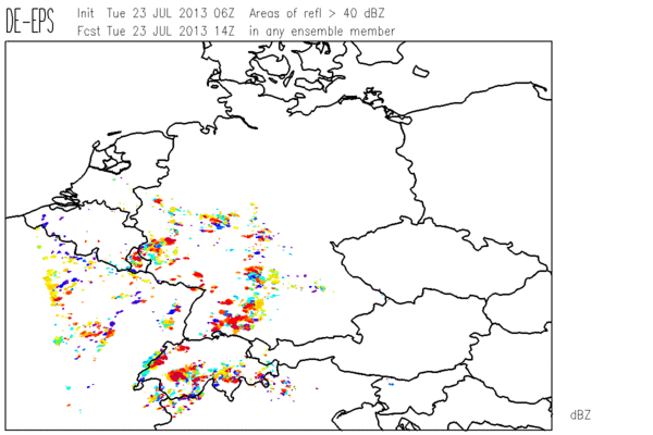
Fig. 4: COSMO-DE forecast for 14 UTC Tue 23 July 2013: areas of simulated radar reflectivity >40 dbZ in the individual EPS runs.

Fig. 5: COSMO-DE forecast for 14 UTC Tue 23 July 2013: percentage of EPS members with a simulated radar reflectivity >40 dbZ.
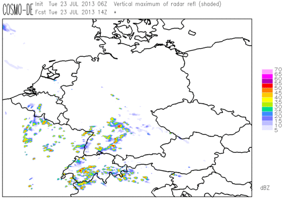
Fig. 6: COSMO-DE forecast for 14 UTC Tue 23 July 2013: simulated radar reflectivity according to the deterministic run.
Since the precipitation signals were even stronger for today (Wed 24 July 2013) in the eastward shifting belt across Central Europe, today’s day 1 team even issued a level 2 area for the Southern half of Germany and a large surrounding level 1 for the rest of Germany, E France and the entire Alpine region. Despite the weak shear, the expected large number of storms was expected to result in rather many hail, wind and rain reports. This slightly controversial decision along with a hint of actionism by Christoph, wo actively involved the other group participants without prior announcement, resulted in a particularly lively online weather briefing today.
Since many of the storms across Germany formed quite early in the day and since Thilo was particularly quick with retrieving severe weather reports, a preliminary verification of today’s forecast can already be done: a few handfuls of heavy rain, severe wind and marginally large hail events occurred mainly over Germany, but probably not enough for a level 2. The forecast models have finally stopped their recent under-forecasting. Darned if you follow them, darned if you don’t!
