
The models seem determined that we are heading towards an exceptional severe weather outbreak in the Western half of Europe in the next couple of days. Forecasting an approaching high-impact situation gets more and more exciting, but also more challenging.
Fig. 1 presents the day 1 forecast issued today (Thu 25 July 2013). The group on duty was working so hard that they ran out of time to issue an explanatory text along with it. 😉 However, a brief reasoning can be presented here, along with a handful of model maps. While the zone of widespread but weakly organized thunderstorms which has concerned us this week so far is slowly leaving the Paris domain to the East (a level 1 area for pulse storms with a main threat of excessive rain over N Italy and Slovenia is its remnant), the coming period of strongly organized convection is expected to be kick-started over SW France today in the evening.
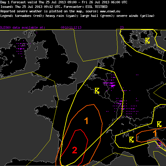
Fig. 1: Day 1 forecast issued today, Thu 25 July 2013.
With the gradual eastward shift of the upper-level jet streak ahead of the Atlantic trough (Fig. 2), steep lapse rates from Iberia and rich low-level moisture accumulation along a convergence zone / sea breeze front are expected to coincide over SW France. This combination results in the first remarkable overlap of CAPE around 2000 J/kg and deep-layer shear between 15 and 20 m/s. Figures 3 and 4 show that GFS, ECMWF and COSMO-EU agree on this scenario despite their different model resolutions and the resulting different representation of the topography.

Fig. 2: ECMWF forecast for 500 hPa geopotential (black contour lines), temperature (colour shading) and wind (barbs) for 18 UTC Thu 25 July 2013.
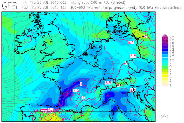
Fig. 3a: GFS forecast for mid-level lapse rates (red contour lines, plotted above 6.5 K/km) and low-level moisture (colour shades) for 18 UTC Thu 25 July 2013.
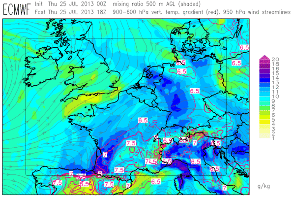
Fig. 3b: As in Fig. 3a, but for ECMWF.
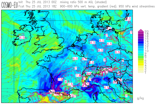
Fig. 3c: As in Fig. 3a, but for COSMO-EU.
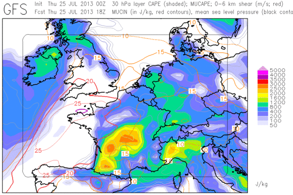
Fig. 4a: GFS forecast for CAPE (colour shades) and 0-6 km vertical wind shear (red contour lines) for 18 UTC Thu 25 July 2013.
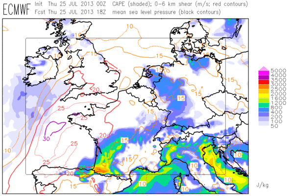
Fig. 4b: as in Fig. 4a, but for ECMWF.
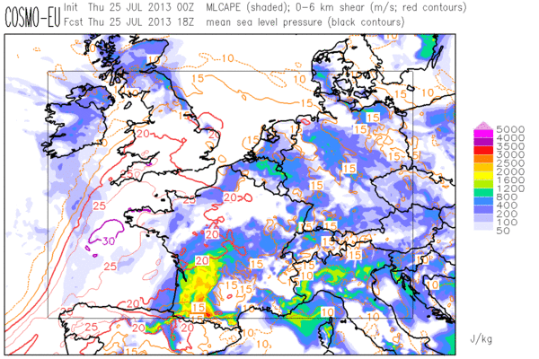
Fig. 4c: As in Fig. 4a, but for COSMO-EU.
The convergence of the low-level wind due to sea breezes and upslope flows is thought strong enough to spark first thunderstorms towards evening, which have good chances to turn into supercells with a threat of large hail, severe wind gusts and locally excessive precipitation. A level 2 was issued for these threats. Even an isolated tornado is not ruled out along the sea breeze front, though it was agreed that the 0-1 km wind shear is rather borderline. Later tonight, the forecast models largely agree on the evolution of an MCS which shall travel northward across France, which is why a level 1 was extended northward for severe wind gusts and excessive precipitation.
Tomorrow (Fri 26 July 2013) looks even more threatening over France, BeNelux and W Germany. The day 2 forecast for tomorrow is presented in full detail in Fig. 4.
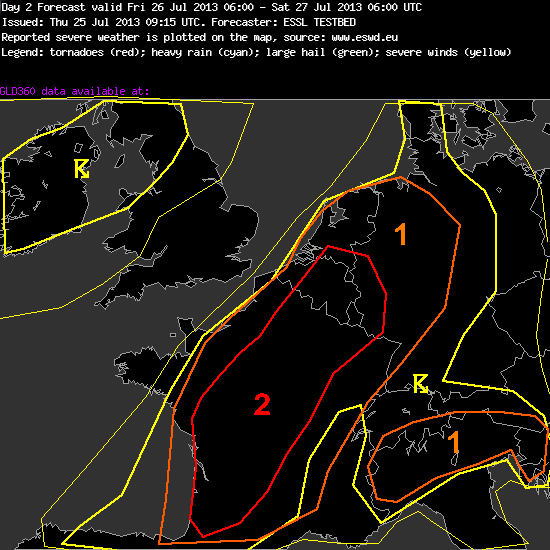
Fig. 5: Day 2 forecast issued on Thu 25 July 2013, valid for Fri 26 July 2013.
—–
Day 2 Forecast
Valid: Fri 26 Jul 2013 06:00 to Sat 27 Jul 2013 06:00 UTC
Issued: Thu 25 Jul 2013 09:15
Forecaster: ESSL TESTBED
A level 1 and a level 2 were issued for large parts of France, Belgium, the Netherlands, Luxemburg and Germany mainly for large hail, severe wind gusts and to a lesser extent for tornadoes and excessive precipitation.
A level 1 was issued for N Italy mainly for large hail and excessive rainfall.
France, Benelux, Germany:
Warm air advection overspreads W and Central Europe from the Southwest. Steep lapse rates originating from Spain, the Pyrenees and the Alps will be advected into France and Germany. Very rich low-level moisture is expected to build up along a wavy front from W France into Benelux. This results in CAPE values around 2000 J/kg, locally even up to 3000 J/kg.
Deep-layer shear is between 20 and 25 m/s beneath the Southwesterly jet streak. Any storm that forms can quickly turn into a supercell. Later towards evening, growth into one or more large MCSes is also possible. Large hail and severe wind gusts pose the main threat. A tornado is not ruled out in areas where plentiful low-level moisture and enhanced 0-1 km shear overlap.
In the absence of synoptic-scale lift, local convergence zones in the low-level wind field act as possible triggers for convection. These include upslope winds (e.g. over the Pyrenees), sea breeze fronts (e.g. over W France) or outflow boundaries from overnight´s convection (mainly over N France, Belgium and W Germany). A level 2 area was drawn where our confidence in convective initiation is best. We left the Netherlands and NW Germany under a level 1, because residual cloudiness from overnight´s convection may limit diurnal heating.
N Italy:
Very rich low-level moisture again results in CAPE around 1000 J/kg. Vertical wind shear remains weak. Pulse storms are expected especially over the mountains with a threat of large hail and excessive rain.
—–
This afternoon, evaluation of the various tested products (NowcastMix, COSMO-DE ensemble prediction system and the Mesocyclone Detection Algorithm) is the primary task, since nowcasting is not so interesting yet. Until now (14 UTC), first weakly organized storms have only formed over parts of Germany and – completely off our radar this week – over parts of Ireland, Sweden and Russia.
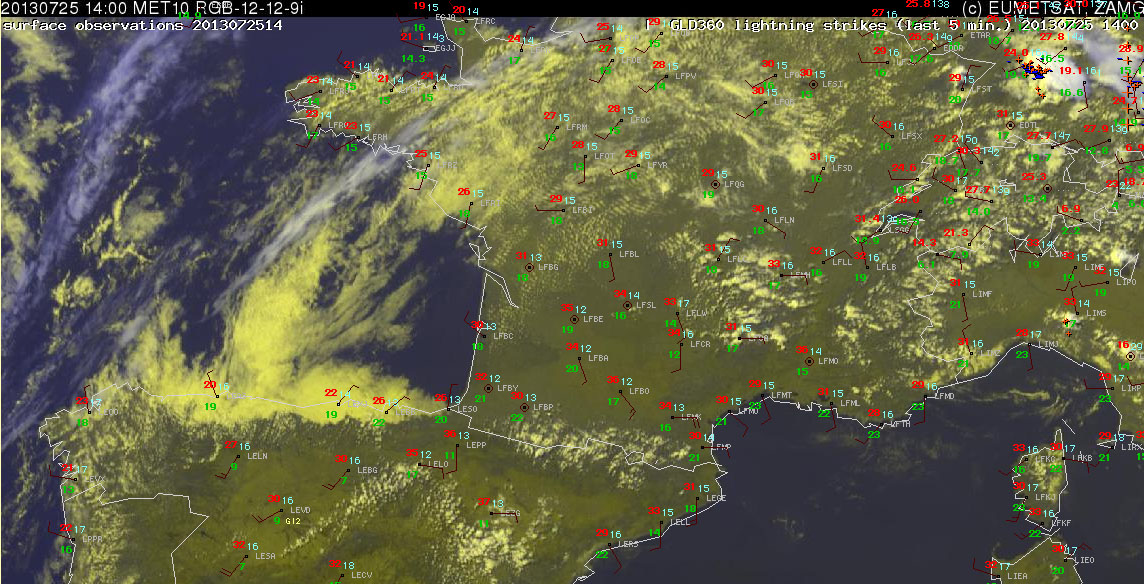
Fig. 6: Nowcast display at 1400 UTC Thu 25 July 2013: E-View satellite image, SYNOP reports and lightning detections within the last 15 minutes.
Everything is still quiet over the level 2 area, in line with our expected late initiation. Satellite imagery showed low stratus until 10 or 11 UTC, which then gave way to unimpeded insolation (Fig. 6). Dew points are around 20°C and temperatures well in excess of 30°C. We will continue to monitor when (and, as pessimists would say: if) storms will explode over the Pyrenees and SW France until we head out for our weekly joint dinner at 1630 UTC. I am sure some of us will even be intrigued enough to even resume monitoring between dinner and bedtime! 🙂

I’m curious when will be the first storms over France, it is 18UTC and is still quiet 🙂
btw i cant belive when i look at GFS forecast at 27.07 There will be conditions for veeery strong thunderstorms.