
Yesterday’s pulse storms (see yesterday’s post) brought quite a lot of severe weather again. Excessive rain and localized severe wind gusts were scattered across France, Belgium, Southern Switzerland (Ticino) and Northern Italy (Lombardia and Alto Adige) in the afternoon and evening. The most stunning event was a fierce hailstorm between Bolzano and Trento in the Italian Alps: hailstones up to 4 cm and hurricane-force gusts managed to destroy 30.000 tons (!) of apples within minutes.
Turning to the second part of yesterday’s ouverture into a possibly memorable week, the hottest day since 2006 in England with temperatures up to 34°C was also followed by a night of widespread thunderstorms, as a short-wave trough provided some lift. These storms were accompanied by localized flooding and an amazing number of damaging lightning strokes, while hail and wind only played a minor role (non-severe hail in London and two cases of fallen trees near Stoke-on-Trent are known so far).
Fig. 1 presents the verification of yesterday’s day 1 forecast and the accompanying text. In general, the lightning areas were aligned pretty well with the detected lightning strokes (magenta dots), but the severe weather events occurred clearly more to the Northeast than expected (Belgium, N France, N Italy), which mainly resulted from an under-estimation of the severe weather potential associated with the pulse storms. The Western level 1, which was mainly issued due to the gradually increasing forcing and shear, verified better.
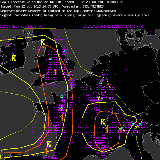
Fig. 1: Verification of the day 1 forecast valid for Mon 22 July 2013.
—–
Day 1 Forecast
Valid: Mon 22 Jul 2013 15:00 to Tue 23 Jul 2013 06:00 UTC
Issued: Mon 22 Jul 2013 14:55
Forecaster: ESSL TESTBED
A level 1 was issued for western France, northern Spain and southern England, Wales and surroundings for excessive rain, large hail and severe wind gusts.
Rich low-level moisture is overlapping with steep lapse rates from the east. CAPE will be around 1000 J/kg in the evening hours across northern France. A mid-level vort-max will move northward along the western French border spreading into the British Isles. Initiation of storm clusters is expected across France and England that move north/north-eastward. Main threat will be excessive precipitation due to rich moisture and due to storm movement parallel to the boundary.
Across France/Spain, larger CAPE enhances the potential of a few hail events. Additionally, vertical wind shear will be around 15 m/s, and a few organized storms are not ruled out. Bowing segments may than pose a threat of severe wind gusts.
Western Alps
Weak winds, high moisture and steep lapse rates are present, convergence in the complex terrain has lead to initiation. Pulse storm and stoirm cluster will be capable of producing isolated large hail or doenbursts. Main threat will be excessive rain due to the slow storm movement.
—–
Not so much change is expected for today (Tue 23 July 2013) yet, hence today’s day 1 forecast is looking pretty similar. The Western level 1 belt was shifted a bit to the East and the Alpine storms were left without a second level 1 area this time.
We are already having one eye at the development of the possible severe weather outbreak over Western Europe towards the end of the week, when GFS and ECMWF agree on an almost incredible weather pattern with a deep and strong SW flow that shall feature abundant CAPE and strong shear. We won’t see forecast maps like these too often in our lives. Fig. 2 shows a handful of them if you promise not to drool!
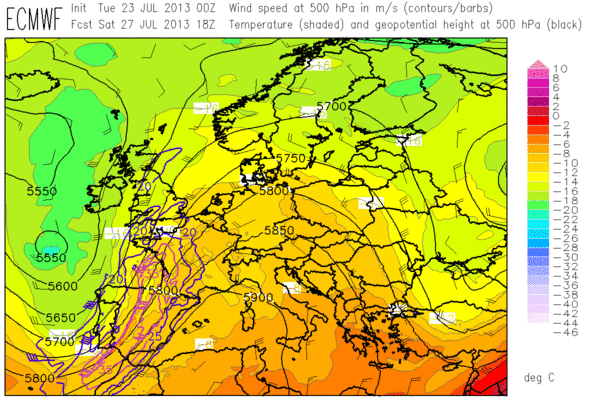
Fig. 2a: Today’s ECMWF forecast of 500 hPa geopotential (black contours), temperature (colour shades) and wind (barbs) for 18 UTC Sat 27 July 2013.
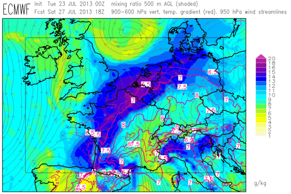
Fig. 2b: Today’s ECMWF forecast of mid-level lapse rates (red contour lines, plotted above 6.5 K/km) and low-level moisture (colour shades) for 18 UTC Sat 27 July 2013 (Paris domain).
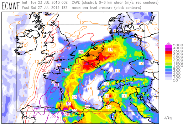
Fig. 2c: Today’s ECMWF forecast of CAPE (colour shades) and deep-layer shear (contour lines) for 18 UTC Sat 27 July 2013 (Paris domain).
Today’s day 5 forecast is already covering Saturday, and it is not surprising that the team on duty used a strong wording – see Fig. 3 and text below.

Fig. 3: Day 5 forecast issued today, valid for Sat 27 July 2013.
—–
Day 5 Forecast
Valid: Sat 27 Jul 2013 06:00 to Sun 28 Jul 2013 06:00 UTC
Issued: Tue 23 Jul 2013 15:11
Forecaster: ESSL TESTBED
The severe weather situation of the previous day intensifies.
Severe weather is expected in France, the Benelux states and the northern part of Germany. With CAPE values up to 3500 J/kg and coincident 0-6 km wind shear of more than 20 m/s, well organized, persistent storm systems producing lightning, heavy rain, large hail, and strong windgusts can be expected.
In northern Italy and the south of Switzerland considerably high CAPE up to 3000 J/kg with weak wind and moderate 0-6 km wind shear less than 10 m/s can lead to slow moving convective cells with heavy rain, lightning, and possibly hail.
—–
Only fly in the ointment: it seems like the biggest storms day(s) will follow just after the end of the last Testbed week.
