
Chuck strived to play Cassandra’s role today: “Forget about yesterday! Today is today!” Was he convincing enough? Doubtlessly, persistence is a good companion these days.
Yesterday (Tue 9 July 2013) thunderstorms fired up over almost the same regions which we already knew from Monday, and which we would recognize again today. In the absence of other lift mechanisms, thermal upvalley and upslope circulations took over the role of trigger mechanisms for thunderstorms over virtually every mountain chain across the Southern half of Europe, where rich low-level moisture beneath still rather cool upper levels enabled moderate instability release (Fig. 1).
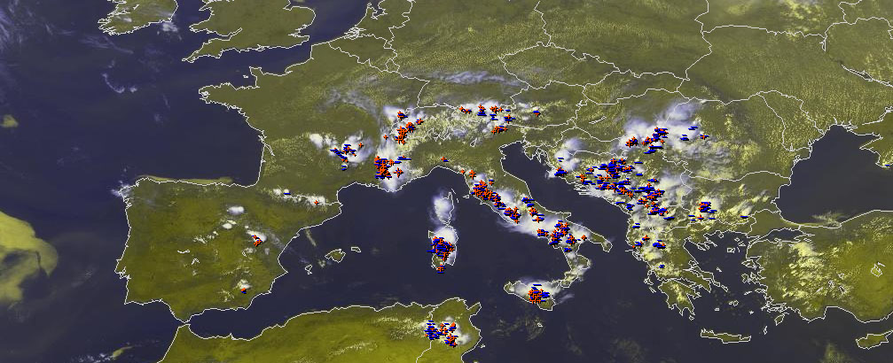
Fig. 1: Nowcast display at 1350 UTC Tue 9 July 2013: Meteosat E-view satellite image and lightning detections within the last 5 minutes. These data were the latest available for the 14 UTC nowcast presented in Fig. 3.
Compared to Monday, less severe weather seemed to have occurred over the Balkans (only one heavy rain report arrived from Croatia). The center of severe storm activity shifted more towards France, where a number of heavy rain and large hail events occurred around the Massif Central, plus a downburst which uprooted numerous trees. Furthermore, several heavy rain events with flash floods were reported across Italy.
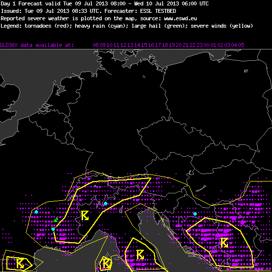
Fig. 2. Verification of the day 1 forecast valid for Tue 9 July 2013.
Yesterday’s day 1 forecast for the Munich domain did not include a level 1 area, hence the verification showed an “underforecasting” of these severe weather activity (Fig. 2). However, again two things need to be emphasized: (1) it is very difficult to anticipate the locations of these dispersed events associated with short-lived pulse storms, and (2) it is not necessarily a mismatch if the severe weather probability is not assumed to be above 5% within a radius of 40 km (which would match our level 1 criteria) at any given point and yet a number of severe weather events occurs, as long as they stay isolated enough. The lightning areas were well forecasted, though also with a negative bias – many areas between the 15% and 50% lightning lines actually received quite a lot of lightning.
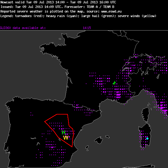
Fig. 3: Verification of the nowcast issued at 14 UTC Tue 9 July 2013, valid for the 14 to 16 UTC period.
The most noteworthy change was that a weak short-wave trough moved over Spain and triggered scattered afternoon thunderstorms after a series of very hot and dry days. Northwesterly upper-level flow increased the deep-layer shear to ~15 m/s, locally even more near the East coast where opposed sea breezes developed. Hence, yesterday’s afternoon nowcasting shifted to the Toulouse domain, and a watch area was drawn in the 14 UTC nowcast (valid until 16 UTC) for Eastern Spain, where the first explosive initiation had just happened (Fig. 3). Large hail and especially severe wind gusts due to the very dry subcloud layers were thought to be the threats. No severe weather reports arrived until today, but this may also be due to the poor reporting rate in Spain. At least several healthy-looking storms occurred over the watch area (Fig. 4).
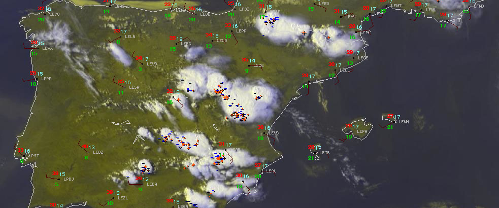
Fig. 4: Nowcast display at 1600 UTC Tue 9 July 2013 (the end of the validity of the nowcast shown in Fig. 3): Meteosat E-view satellite image, SYNOP reports and lightning detections within the last 5 minutes.
Today, even more storms formed over Spain, whereas not much change could be noticed elsewhere… yet. Stay tuned for today’s second post, which will outline today’s forecasts and possible changes in the near future! Our guest writer will now take over again!
