
The stable weather pattern also continued during Day 3 (Wednesday) of the second testbed week but despite that constant, the preparation of the Day 1 outlook became pretty intensive with lots of fruitful discussions. A small area in our forecast region even was thought to be ready for supercell development during the afternoon/evening hours! Who would have thought that when scanning through the maps 1 or 2 days ago.
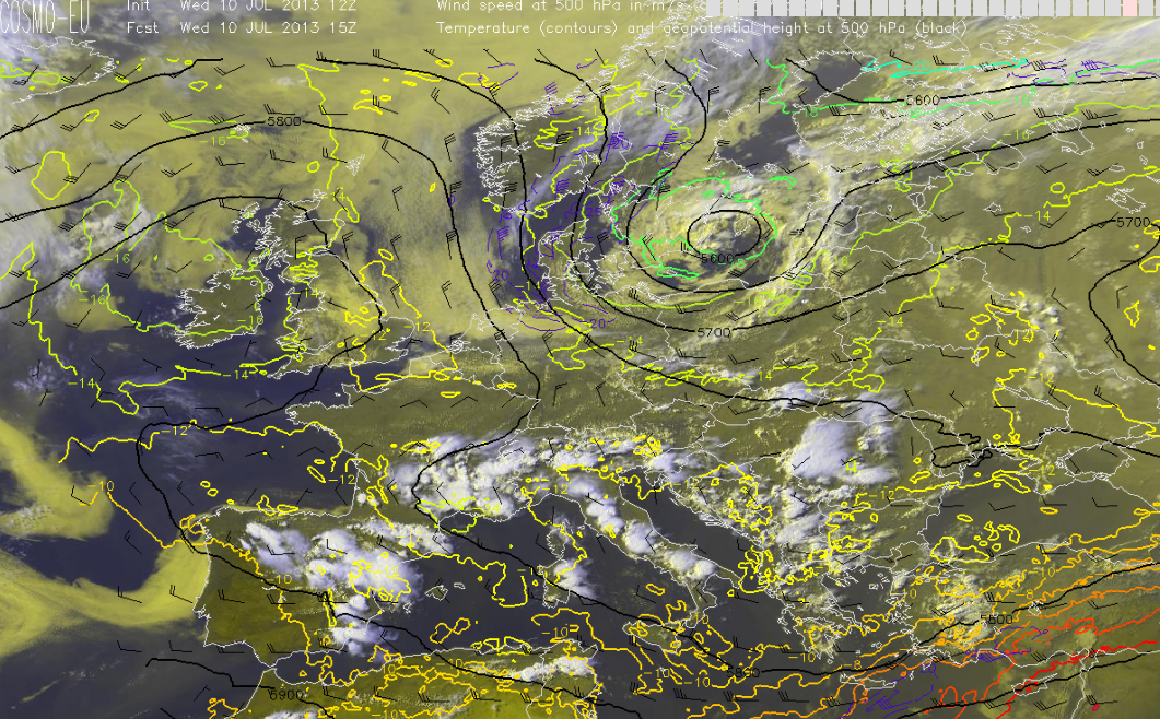
Fig.1: Visible image with 500 hPa data atop (wind highlighted as barbs, black lines for geopotential heights and the coloured lines for the temperature). @ 16 MESZ
No change in the major pattern is seen in Fig. 1 compared to the past 2 days. But I can tell that today’s discussion becomes more interesting weather-wise than what you would probably expect with a sentence beginning with “no change”. The stout ridge finally left far W-Europe and is now placed over the far E-Atlantic. What was left behind can be described as an extensive area with cool mid-level air, weak height gradients and numerous mid/upper cyclonic vortices over southern Europe. With upper air map (and hand) analysis (00 UTC) we analyzed one mid tropospheric vortex over S-France, another one over NW Italy an a third one over the far S-Adriatic Sea. 14 hours later (16 MESZ), those vortices weakened and evolved into numerous west-east aligned upper level troughs. All areas south of the Alps once again saw rich boundary layer moisture with surface dewpoints in the mid to upper tens, so combined with those cool mid-level temperatures (moderate lapse rates), we expected widespread MLCAPE build-up in the order of 500 to 1000 J/kg with locally even higher values. Deep layer shear remained weak, so we expected pulsating thunderstorms with a transient hail and severe wind gust risk. Thunderstorms then should grow upscale into multicell clusters which might produce concentrated swaths of strong to isolated severe wind gusts, a few large hail reports and heavy rain. The Day 1 group (forecasting for today/Wednesday until Thurday 06Z) decided to concentrate on the Toulouse area (including Spain/Portugal/France/Switzerland and NW Italy/S-Germany) as ingredients over the Balkan States did not look as impressive as they did 24 to 48 hours ago.
However there was also another reason for shifting to the Toulouse area. Spain became the focus for organized convection … especially areas from N-Spain to the Pyrenees and along the east coast all the way down to the Sierra Nevada.
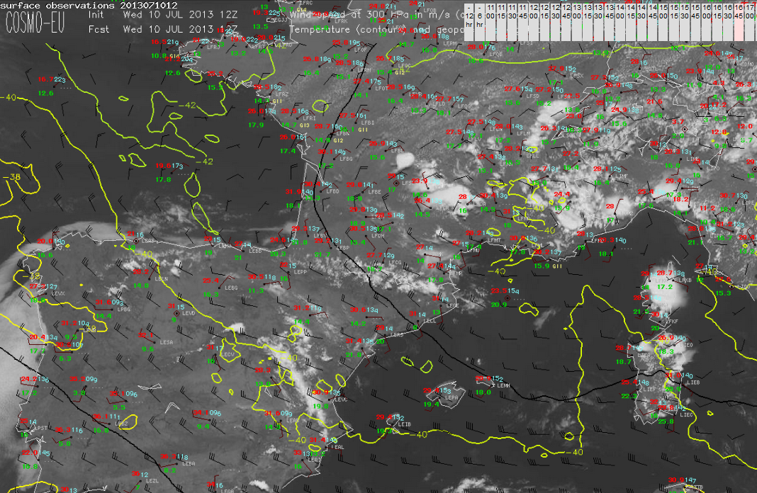
Fig.2: Surface observation with 300 hPa wind barbs atop. Background is a visible image. @ 1645 MESZ
You see the set-up just before thunderstorms initiated along the mountains from northern into eastern Spain. Most parts of the Iberian Peninsula experienced 30-40 kt NW-erly flow which caused 10-15 m/s (6 km) shear mainly over eastern Spain. Like yesterday we expected intense heating over Spain and strengthening onshore flow from the western Mediterranean which eventually would advect rich boundary layer moisture ashore along the east coast of Spain. Surface dewpoints indeed approached 20 °C along the E-coast during the noon and afternoon hours. There, many stations also reported easterly or southeasterly winds with sustained speeds of 10-15 kt. So it was not a surprise that forecast soundings and models all showed strengthening directional shear (enhanced storm relative helicity within the lowest 3 km) beyond 15 UTC over the east coast of Spain. Most models expected SRH-3 of 200 – 300 m^2/s^2 with 500 to 1000 J/kg MLCAPE, with an increase/decrease of CAPE/shear to the north. So we expected another round of mountain thunderstorm development around noon due to strong capping below 800 hPa (hence areas away from the mountains would remain capped for surface based initiation). High based thunderstorms and moderate deep layer shear all indicated a risk of a few severe downburst and large hail events. However it was thought that the main concern would arise for those storms as they would eventually move east into an increasingly more unstable and stronger sheared environment along the E/SE coast of Spain. We expected a few supercells with large to isolated very large hail, strong to isolated severe wind gusts (although cap could limit that risk) and heavy rain. In addition, rich boundary layer moisture along the coast should bring LCLs down a bit and an isolated tornado event was not ruled out. That’s why we increased probabilities to a level 2 for the east/southeast coast of Spain. For the rest of N/NE Spain a level 1 for large hail and a few severe downburst events next to heavy rain was issued. While writing this post, radar data of Spain indicates numerous intense thunderstorms with sharp reflectivity gradients and somewhat more southerly (deviant?) storm motions (compared to thunderstorms to the north) southwest of Valencia (17 UTC)….those storms are just about to enter the more volatile air mass so we’re looking forward how those thunderstorms will behave during the evening hours well into the overnight hours.
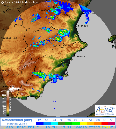
Fig.3: Radar data from AEMET @ 1640 MESZ
During the afternoon hours I worked with the group which prepared Day 3 and Day 4 outlooks. The Day 3 outlook will be described a bit as this day could become the more active one regarding organized thunderstorm development over at least three different regions.
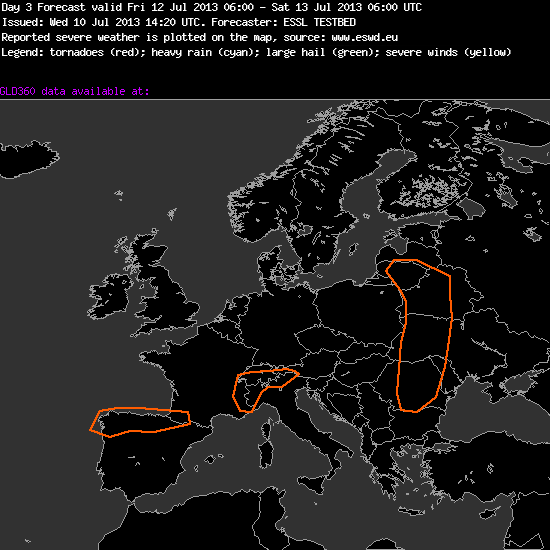
Fig.4: Severe areas are highlighted with orange colours.
+++++++++++++++++++++++++++++++++++++++++++++++++++
Day 3 Forecast
Valid: Fri 12 Jul 2013 06:00 to Sat 13 Jul 2013 06:00 UTC
Issued: Wed 10 Jul 2013 14:20
Forecaster: ESSL TESTBED
Severe weather is expected in:
1. Northern Spain: A Low approaching from the North, with lots of moisture and very high cape (2000-4000 J/kg) risk: some organized TS with large to very large hail and severe wind gusts.
2. Alps: Capes around 2000 J/kg,but not so much shear, so we expect only clustering storm but they can produce heavy rain, and some hail.
3. Eastern Europe influenced by a coldfront but it is uncertain where the coldfront will be located (Different models). With the coldfront moderate shear and moderate cape could produce some severe weather events.
++++++++++++++++++++++++++++++++++++++++++++++++++++++++++++
The best point to talk about : we finally expect an area with a broad CAPE/shear overlap and increasing probabilities for organized thunderstorms. As mentioned yesterday, a cut-off low over Poland will move east with a decrease in forward speed. At the same time, a cold front is forecast to push east towards Belarus and W-Ukraine. All models agree with this scenario although there are some discrepancies where to place the cold front and how fast the slow-down of the forward speed of the main upper low will be. Those points will impact our final severe risk, but today all models showed at least an overlap of 10 to 15 m/s 0-6 km shear and 500 to 1000 J/kg MLCAPE along the eastward moving cold front. We included that uncertainty by increasing the width of the severe risk area in east/west but also in north/south direction. With decreasing forcing (as the cut-off weakens and slows down) we do not expect a foreced line or a well organized MCS event but we could easily see a few multicells/isolated supercells which could produce large hail and strong to severe wind gusts. Definitively an area to look at.
The second area which was highlighted over NW/N Spain into extreme SW France will be placed ahead of a slowly SE-ward moving upper low, which starts to come ashore over NW Spain during the overnight hours. Days of persistent onshore flow and evapotranspiration beneath very steep lapse rates should cause a belt of strong to isolated extreme CAPE build-up in the order of 2000 – 3000 J/kg within the severe risk area. Shear remains wek (0-6 km bulk shear around 10 m/s), but combined with those CAPE values we would expect to see a few explosive thunderstorm developments with large to isolated very lage hail, severe downbursts and excessive rainfall amounts (due to slow storm motions). If those CAPE values continue to show up in the following model runs, we might think about that this event maybe exceeds our level 1 probabilities.
The third severe area over far NW Italy and extreme SE France just reflects the well known “500 to1000 J/kg and no shear environment”, which we already saw during the past few days. A few multicell clusters with heavy rain, isolated large hail and gusty winds likely evolve.
For Day 4 we issued a very similar map with two severe risk areas (one over N Spain and the other one over NW Italy). However we did not continue to highlight the cold front over Belarus/Ukraine as shear gradually weakens and forcing becomes very diffuse.
So to finish this post, we’re looking forward to a few active thunderstorm days during the last 2 days of the testbed week!
