
It’s July, the sun shines from a cristal blue sky, people smile and everyone is happy …. everyone? Well there is a group of forecasters and scientists in Vienna Neustadt, which really looks forward to some changes in the ongoing weather pattern. And there is indeed a silver lining on the horizon for some more organized convection for the following days over eastern Europe. However today it is Tuesday and Tuesday still had a huge surface high pressure area over a big part of western and central Europe, so no major changes were yet seen.
The figure below should offer you a short overview about the conditions on our second testbed day:
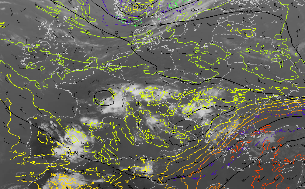
Fig.1: IR 10.8 satellite and 300 hPa winds (barbs), heights (lines) and temperatures (colored lines)
Group 1 forecast for Tuesday (Day 1): The dominant high pressure area which extended from Spain all the way to the UK continued its gradual weakening trend and left behind a broad area with fairly weak height gradients at 500 to 300 hPa. In this figure you can still see the broad cyclonic circulation which meanders over Italy and the Adriatic Sea. Filled with cool mid-level air atop hot and humid lower levels set the stage for another round of active thunderstorm development over an extensive area. This includes most of Italy, Corsica, Sardegna and the Balkan States. In addition you can see another cyclonic vortex over S-France which likely assisted in thunderstorm development from SE France into Switzerland. Like it was the case during the past few days, shear at all levels was forecast to stay weak with 0-6 km bulk shear remaining below 10 m/s during the forecast. However we noticed a gradual increase in boundary layer moisture and hence also an increase in expected CAPE build up with models pointing to local peaks well in excess of 1500 J/kg mainly over SE France. We once again issued our 50-% lightning areas along the mountain ranges, surrounded by a broad 15-% lightning area which was very similar to Monday. However, during the day today we received some worrisome reports of heavy rain and very intense wind gusts with Monday’s convection (e.g. a wind gust of 35 m/s over southeastern France (not yet verified) and some flooding problems in the western Balkan States [see http://www.essl.org//cgi-bin/eswd/eswd.cgi ]) so we are afraid that we might have underestimated the risk for Tuesday in our DAY 1 forecast. We might end up seeing level 1 conditions from the Massif Central to the east but also over parts of the Balkan States as those thunderstorms really had healthy looking updrafts (overshooting tops) and even better CAPE to work with compared to Monday. We will see in tomorrow’s verification how our reluctant forecast without any level 1 areas worked out. Another area we were concerned about evolved over northeastern Spain, where onshore flow advected better moisture well ashore. All models showed some more or less aggressive signals for initiation with high based (severe downburst prducing) thunderstorms and fat mid-level CAPE profiles (isolated large hail). However we were unsure about the final magnitude of initiation due to ongoing capping issues, so we decided the stay with the safe forecast and issued our Day 1 forecast once again for the Munich domain (e.g. from Italy to S-Germany into the Balkan States).
Group 2, forecasting for day 2:
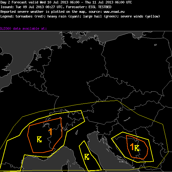
Fig.2: DAy 2 outlook with yellow lines representing the thunderstorm areas (15-% thin lines and 50-% thick lines) and orange lines showing the level 1 areas.
I don’t want to spend too many words on tomorrow’s outlook (for Wednesday) as no serious change in the weather pattern is forecast. However this group increased probabilities and issued two level 1 areas, given once again improving boundary layer moisture forecasts (with modest mid-level lapse rates atop also increasing CAPE forecasts).
##################################################
Day 2 Forecast
Valid: Wed 10 Jul 2013 06:00 to Thu 11 Jul 2013 06:00 UTC
Issued: Tue 09 Jul 2013 08:27
Forecaster: ESSL TESTBED
Group: MAP Room
Balcan Area: expect strong wind, heavy rain ,small hail, some instabilty,
Pulse severe events, poorly organised
Alps and southern France (incl. massiv central):
on the border of moist and hot air on south and dry on north, around Alps, France and Pyrenees (Border between France and Spain). Poorly organised pulse storms.
Expect heavy rain, strong wind and small hail
Italy:
Poorly organised pulse storms
expect localy heavy rain, localy strong wind gusts
###################################################
During the afternoon hours we once again split up into two groups, one watching the nowcast for watch issuance and the other group preparing outlooks for Day 3 to 5. In the nowcast group the focus for watch issuance shifted to northeastern Spain due to the severe downburst, isolated large hail and locally heavy rainfall risk. In addition we already had initiation over the mounatins in Italy, the Massif Central, the Alps and the Balkan States. I added a RapidSandwich product of 1830 UTC from Spain:
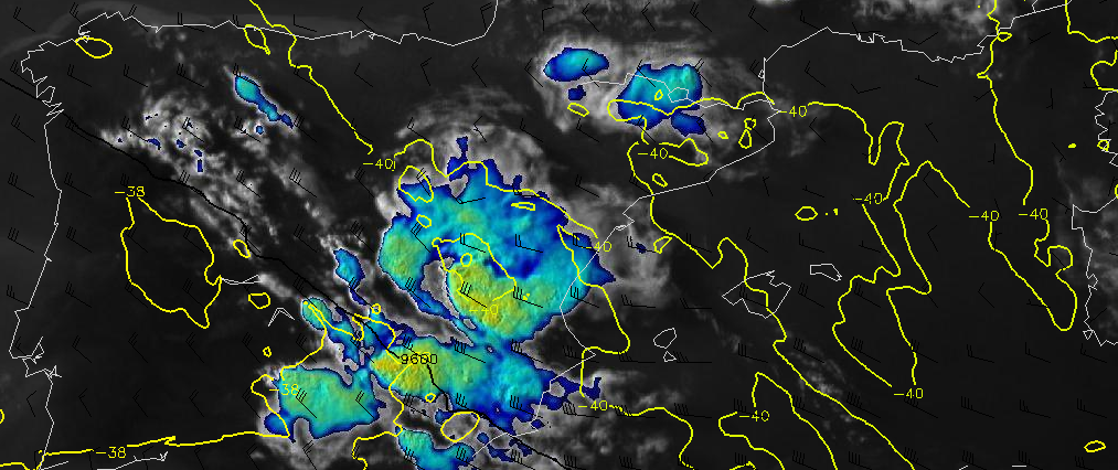
Fig. 3: Rapid Sandwich product, showing the cloud top temperatures at 1830 UTC for Spain and Portugal. Wind barbs show 300 hPa wind speed.
The thunderstorms developed along the mountains and remained there for one to two hours before moving slowly off to the east. You can see somewhat stronger 300 hPa winds over Spain and we had 10 to 15 m/s of deep layer shear (6 km bulk shear) mainly over southeast into eastern Spain. Therefore we expected a few better organized multicells and we’re eagerly looking forward to see some reports tomorrow in the ESWD.
The other group prepared the Day 3 to Day 5 outlooks and I will show the DAY 4 outlook to also describe the others:
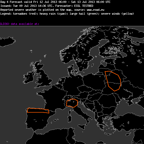
Fig.4: Orange lines showing where some enhanced probabilities for severe thunderstorms are forecast.
On all three days we we see ongoing pulsating and mainly daytime driven thunderstorm development over parts of northern and eastern Spain, south France, Italy and the Alps into the Balkan States. We probably continue to issue level 1 areas for this activity, where highest CAPE and thunderstorm coverage is anticipated. However you can also see a severe risk area over Belarus into the Ukraine. A trough from Norway and Sweden moves south on Wednesday and closes off over Poland during Thursday and Friday. This feature will add some overlap of shear and CAPE, so we finally expect also more organized thunderstorm development during the following days of our testbed week mainly from Poland to the south and east. We’re surley looking forward for this change!
