
The tornado outbreak of 24–25 June 1967 remains the second deadliest tornado outbreak over Europe since 1950 after the tornado outbreak of 9 June 1984 over Russia. Over the course of two days, one F2 tornado, four F3 tornadoes, one F4 tornado, and one F5 tornado struck France, Belgium and Holland (Fig. 1), resulting in 15 fatalities and 234 injuries.
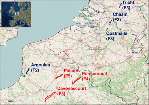
Figure 1. Tornado tracks from 24 (red) and 25 (blue colour) June 1967.
In a study from 2018, a team led by Bogdan Antonescu looked at the details of the outbreak and at what would be the consequences if a similar tornado outbreak will occur 50 years later (i.e., 2017). This was done by transposing the seven tornado tracks from the June 1967 outbreak over the modern landscape. Due to urban growth, it is possible that tornadoes could cause even more impact than in 1967. Based on the statistics of fatality and injury rates associated with European extracted from the European Severe Weather Database, a similar tornado outbreak with the one that occurred in 1967, would result in 55–2580 injuries, and 17–172 fatalities. In the worst-case scenario, with tornado tracks moving over highly populated areas over the region, up to 146 222 buildings could be impacted with 2550–25 440 injuries and 170–1696 fatalities. This study clearly shows how impactful such a tornado outbreak could be to society.
A follow-up study that has just been published in Weather and Forecasting (link) hindcasts the tornado outbreak using an WRF-ARW simulation, with initial and boundary conditions provided by ERA-40 reanalysis and the highest-resolution domain with 800-m grid spacing. The model simulated an environment conducive for tornadic supercells with CAPE exceeding 2000 J/kg, 0–6 km bulk shear between 20–25 m/s and Storm Relative Helicity reaching 300 m²/s² in the 0–3-km layer. The model was also able to explicitly simulate a number of supercells over the region of interest (Fig. 2).
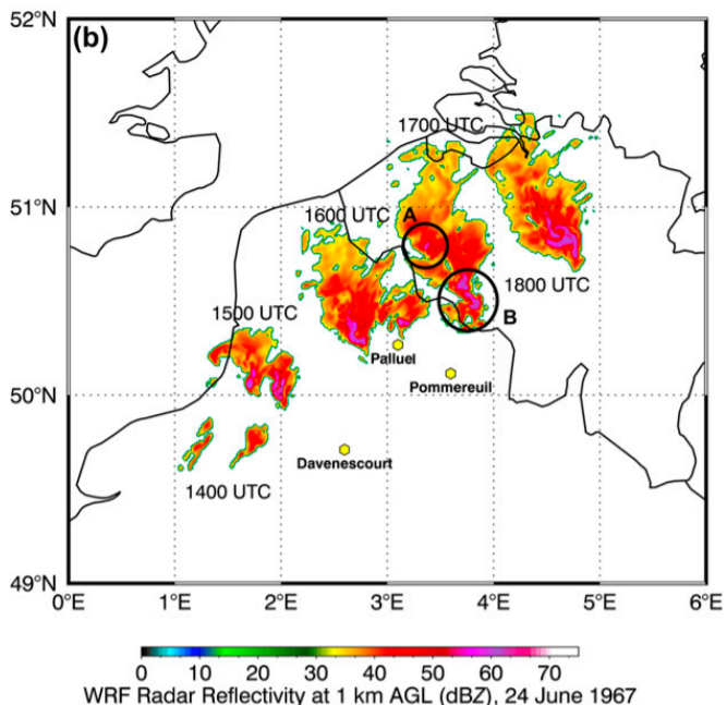
Figure 2. Timestamps of radar reflectivity echo at 14, 15, 16 and 17 UTC on 24 June 1967.
One of the questions posed by the article is how would a forecast of such an event look like today? To do this, an ESTOFEX forecaster was presented with a set of forecast maps for both days (without knowing the dates) and asked to provide Day-1 outlooks. The forecaster issued Level 3 (the highest risk of severe weather) for both days, on (Fig. 3). This paper demonstrates that, with our understanding of severe convective storms and state-of-the-art numerical modelling, a forecast of a tornado outbreak over Europe is possible. Given how much societal impact significant tornadoes can cause, addressing their threat should be part of any convective storm forecast.
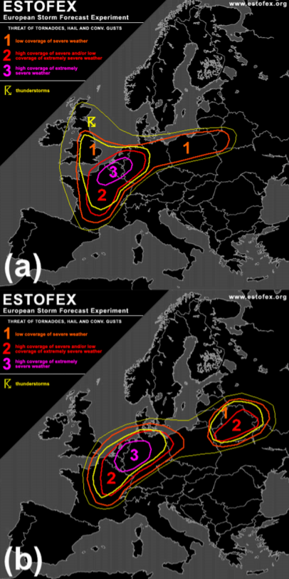
Figure 3. ESTOFEX hindcast outlooks for a) 24 June 1967 and b) 25 June 1967.
Full versions of both studies can be freely accessed here:
Antonescu, B., J.G. Fairman Jr, and D. M. Schultz, 2018. What is the worst that could happen? Reexamining the 24–25 June 1967 tornado outbreak over Western Europe. Weather, Climate, and Society, 10, 323–340.
Antonescu, B., T. Púčik, and D. M.Schultz, 2019. Hindcasting the First Tornado Forecast in Europe: 25 June 1967. Weather and Forecasting, 35, 417–436.
