
The atmosphere seems to have fallen into estivation at the begin of the 2nd Testbed week. Apart from a far Northward displaced frontal zone over Scandinavia which does not touch any unstable areas, very weak geopotential gradients cover most of Europe. Thunderstorm activity is confined to the Southern half of the continent these days, where slightly lower 500 hPa geopotential heights and temperatures allow low to moderate CAPE and convective initiation over orographic features.
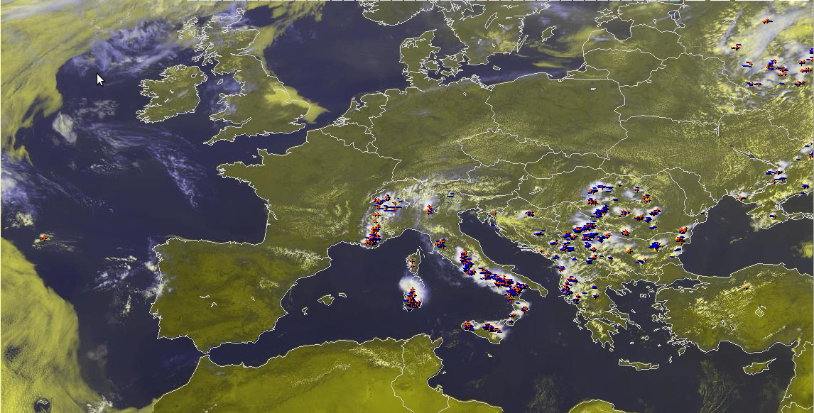
Fig. 1: Nowcast display at 1300 UTC Mon 8 July 2013: Meteosat E-View satellite image and lightning detections within the last 15 minutes.
By 13 UTC, the 10 new participants of the second Testbed week (from Latvia, Lithuania, Poland, Germany, Bosnia-Hercegovina, Spain and the USA) were ready to issue their first day 1 and 2 forecasts. Fig.1 shows the situation at that time as displayed in our Nowcast Monitor. Since the already high thunderstorm coverage over much of the Balkans did not make forecasting for the Sofia domain very challenging any more, the group for the day 1 forecast (today, Mon 8 July 2013) decided to take the Toulouse domain. Also there, it was a safe bet to include e.g. the Western Alps and Sardegna into a >50% thunder area, but a later (or even failing) convective initiation added welcomed higher forecast uncertainties further West. The situation was particularly tricky for NW Spain, which was by the way also the only region in Europe which saw more significant deep-layer shear (15-20 m/s). The coastal stations showed temperatures above 30°C and dew points around 18°C, therefore it was believed that the localized CAPE maxima around 1000 J/kg which were uniformly forecasted by the models were realistic. However, the latest satellite images did not show even the smallest cumulus clouds and in the absence of more organized lift, the sea breeze front alone was thought too weak to break the rather massive cap on top of the maritime boundary layer. In order to play it safe, a low probability thunder area was issued for NW Spain but no level 1 was issued. The entire forecast with preliminary lightning detections until the time of writing can be seen in Fig. 2 (plus text below).
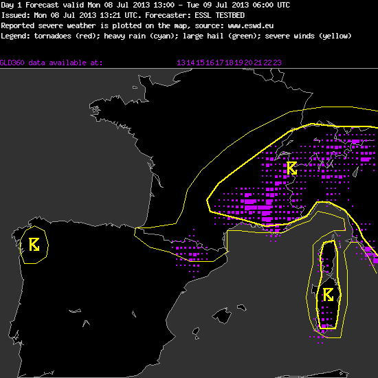
Fig. 2: Day 1 forecast for Mon 8 July 2013.
—–
Day 1 Forecast
Valid: Mon 08 Jul 2013 13:00 to Tue 09 Jul 2013 06:00 UTC
Issued: Mon 08 Jul 2013 13:21
Forecaster: ESSL TESTBED
No threat levels were issued.
…other comments…
Western Alps, Italy, Corsica, Southern France, Pyrenees: Rather widepsread [storms] expected this afternoon and evening over orographic features. 12 UTC soundings showed CAPE around 1000 J/kg in areas with better low-level moisture (e.g. Milano, Payerne). Vertical wind shear is very weak. Storms will stay unorganized. Localized heavy rainfall is the only threat worth mentioning.
Convective initiation is a bit more doubtful over the Pyrenees due to less low-level moisture and a stronger cap.
NW Spain: surface observations show that rich low-level moisture from coastal areas locally gets advected inland, leading due a buildup of moderate CAPE. However, due to a strong cap and no sources of organized lift convective initiation is not too likely.
—–
More about that will come in tomorrow’s verification session. Meanwhile, the other group worked on the day 2 forecast (Tue 9 July 2013). They chose the Munich domain (honi soit qui mal y pense: did they want to avoid a similar hassle with initiation or non-initiation of storms over the Iberian Peninsula?), but apart from that the forecast did not look much different. Neither will the forecasts for the rest of the week, we are afraid.

Fig. 3: Pet peeve alert! (Alois’ pic)
Afternoon activities were a bit reduced, as the quiescent weather made people’s minds drift back to more active days in the recent past and a lively discussion about some of Chuck’s pet peeves (diffluence vs. divergence, and divergence/convergence in relation to vertical motions) inflamed (Fig. 3).
